
YOUR NUTSHELL: The Earth keeps being buffeted by geomagnetic storming, with some faint aurora pics sent to me from overnight as the Kp Index rose to 7, so please post any pics below if you saw it. As for our surface weather, fair conditions continue today and tomorrow with plenty of sunshine after a chilly start today with highs either side of 80º today and into the 80s tomorrow. Hazy skies will develop from wildfire smoke passing overhead Wednesday, and I’m unsure how much smoke will make it to the ground, if any, but I will update you. Thursday starts off sunny with peaking humidity and temps as highs rise into the mid 80s to low 90s with a few showers or a thunderstorm by late afternoon. However, it’s Friday into Saturday which will feature a slow-moving cold front moving through the region, which will focus very warm temps, high humidity, and periods of showers and some thunderstorms in our region, before we clear out for Sunday into early next week, and cool down a bit in the process.
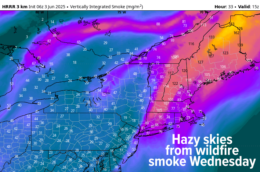
TABLE OF CONTENTS
* Daily Celestials (Sun/Moon)
* Sponsor Section
* Morning Discussion
~~~~~~~~~~~~~~~
YOUR DAILY CELESTIALS
~~~~~~~~~~~~~~~~~~~~~~
STAR:
–OUR STAR ROSE AT: 5:16am this morning
–OUR STAR SETS AT: 8:21pm this evening
–TOTAL DAYLIGHT TIME: 15 hours and 5 minutes
MOON:
–OUR MOON RISES AT: 1:07pm this afternoon
–MOON RISE DIRECTION: East
–OUR MOON SETS AT: 1:48am tomorrow morning
–MOON SET DIRECTION: West
–MOON PHASE: Waxing Gibbous (53.2%)
~~~~~~~~~~~~~~~~~~~~~~
A NOTE FROM OUR SPONSOR
~~~~~~~~~~~~~~~~~~~~~~
Dave Hayes The Weather Nut is Sponsored by Individual Community Members, Patrons, and Tandem Bagel Company… No matter the weather, Tandem Bagel is always there for you at several valley locations to make your mornings brighter! With *New Pizza Bagels(!)*, along with bagels baked fresh daily (including Gluten-Free options), house-whipped cream cheese, coffee, and tons of lunch options, Tandem is the perfect quick stop for lunch, breakfast, or a coffee and bagel to go.
You can either 1) visit them in Easthampton, Northampton, Hadley, Florence, West Springfield, and/or Ludlow, 2) hire them to cater your next event, or 3) use their super-streamlined online ordering tool by visiting their website and clicking the “Catering” or “Order Online” links.
~~~~~~~~~~~~~~~~~~~~~~
YOUR MORNING DISCUSSION
~~~~~~~~~~~~~~~~~~~~~~
Good morning everybody, our upper low has finally kicked off to the east after leaving us with one last chilly night and morning. Soak it up, cool season appreciators, because summah lovahs are about to suit up, jump off the bench, and bask in warmth and humidity through the end of this week.
Sunshine will dominate today, tomorrow, and much of Thursday, though clouds will be building on that day as humidity builds into the region.
Today / Tuesday will feature a light west wind, sunshine and highs climbing into the mid 70s to low 80s with one last day of dry air. Lows will dip into the low to mid 50s under clear skies.
For Wednesday, humidity will be increasing as high pressure moving through today, will position itself to the south of us tomorrow, generating southerly and southwesterly return flow, which pumps the heat and humidity into our region as we finally switch up from a cold season pattern to a warm season one, which is right on time now that we’re in June. Watch for wildfire smoke in the skies, which should produce haze at times.
Highs under sunny skies will be very warm, climbing into the mid to upper 80s for many of us (perhaps low 80s in parts of SVT), and you’ll feel it getting muggier. Lows will dip into the upper 50s to low 60s.
Thursday represents peak heat as temps soar into the mid 80s to low 90s and dewpoints crest the 65-70º range, so a legit summer day is on the way for Thursday. In addition, clouds will be building, and we could see some isolated to scattered showers or a few thunderstorms by later afternoon or evening. Lows will drop into the low to mid 60s.
By Friday and Saturday, we’re looking at a cold front that will be approaching the region slowly, and as such, it will likely focus periods of showers and/or thunderstorms into our region both days, while remaining warm and humid for Friday, and cooling a bit Saturday.
Highs will climb into the low to mid 80s Friday, and the morning may feature some partial sunshine. By Saturday, temps should be hanging in the 70s for highs.
As far as more granular timeframes of impacts, we’ll have to get closer to that time, as it’s not clear yet how things are more likely to play out, but it does looks wet and humid at the moment.
Sunday and Monday should clear out and become sunnier with highs in the mid to upper 70s both days, and after a couple of showers Tuesday, we hopefully will resume some sunny sky action for mid-week.
Have a great day, and may good things come your way!
“Follow your bliss and the universe will open doors for you where there were only walls.”
― Joseph Campbell