
TABLE OF CONTENTS
* Daily Celestials (Sun/Moon)
* Sponsor Section
* Morning Discussion
~~~~~~~~~~~~~~~
YOUR DAILY CELESTIALS
~~~~~~~~~~~~~~~~~~~~~~
STAR:
–OUR STAR ROSE AT: 5:13am this morning
–OUR STAR SETS AT: 8:28pm this evening
–TOTAL DAYLIGHT TIME: 15 hours and 15 minutes
***PEAK 2025 LIGHT, FOLKS***
MOON:
–OUR MOON SETS AT: 11:30am this morning
–MOON SET DIRECTION: West
–OUR MOON RISES AT: 12:41am tomorrow morning
–MOON RISE DIRECTION: East
–MOON PHASE: Waning Gibbous (64.8%)
~~~~~~~~~~~~~~~~~~~~~~
A NOTE FROM OUR SPONSOR
~~~~~~~~~~~~~~~~~~~~~~
Dave Hayes The Weather Nut is Sponsored by Individual Community Members, Patrons, and Tandem Bagel Company… No matter the weather, Tandem Bagel is always there for you at several valley locations to make your mornings brighter! With *New Pizza Bagels(!)*, along with bagels baked fresh daily (including Gluten-Free options), house-whipped cream cheese, coffee, and tons of lunch options, Tandem is the perfect quick stop for lunch, breakfast, or a coffee and bagel to go.
You can either 1) visit them in Easthampton, Northampton, Hadley, Florence, West Springfield, and/or Ludlow, 2) hire them to cater your next event, or 3) use their super-streamlined online ordering tool by visiting their website and clicking the “Catering” or “Order Online” links.
~~~~~~~~~~~~~~~~~~~~~~
YOUR MORNING DISCUSSION
~~~~~~~~~~~~~~~~~~~~~~
Good morning folks, the overall theme of our upcoming weather is increasing moisture and humidity, which really ramps up late tonight and tomorrow into tomorrow evening, and peaks on Thursday.
We’ve got some showers around this morning, but they are generally light as a weak wave wafts through our flow, with temps starting in the 50s to low 60s. Some drizzle is also possible.
We should remain mostly cloudy today with highs in the upper 60s to low to 70s, and the middle of the day is expected to be drier before another wave with some more scattered showers arrives late afternoon and early evening with lows dipping into the low to mid 60s.
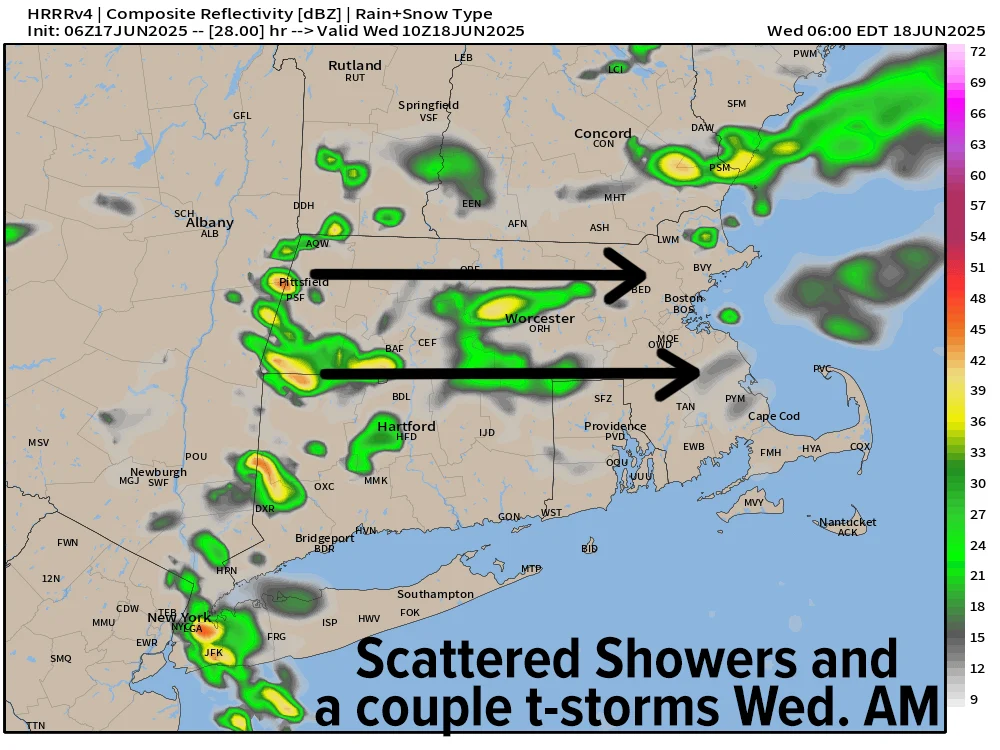
By early Wednesday morning, a more robust wave on the nose of higher humidity and warmer temperatures pushing our way will spark some heavier scattered showers and perhaps a morning thunderstorm or two.
However, clouds will still dominate and help to tamp temps down into the mid 70s to low 80s. If we can work in some sunny breaks of any length by afternoon we could hit the mid 80s. Lows Wednesday night will drop into the mid to upper 60s.
Winds are generally lighter through this period as we switch from southeast flow today to southwest flow by Wednesday evening.
On Thursday, I am expecting a sunnier day, which will coincide with a peak in humidity and air temps with dewpoints either side of 70º and highs in the upper 80s to low 90s (possibly hitting the mid 90s in a few southern valley spots).
As a cold front slices toward New England draped off a potent low pressure system near the Canadian border tracking east, we should see a broken squall line develop with clusters of showers, downpours and thunderstorms.
As this activity presses into western New England, it should combine with instability and wind shear to produce scattered strong to even severe thunderstorms with damaging wind gusts possible in isolated areas.
I will refine the timing of this more by tomorrow, but right now it looks like mid to later afternoon.
This activity sweeps the region by the evening, leaving us with drying conditions and lows in the low 60s.
While a few showers are possible Friday, it should be a mostly sunny day as a less humid air mass enters the region helping to produce westerly gusts up to 20mph or so. Highs will climb into the mid 70s to low 80s with lows in the upper 50s.
Saturday, for now, continues to look like a fair weather day with highs in the low to mid 80s under partly to mostly sunny skies, though clouds may increase at night with a small wave moving into central New England.
This small system could bring some showers overnight Saturday into early Sunday morning before drying by Sunday afternoon, especially north of the Pike. Highs Sunday would be warmer, climbing into the mid to upper 80s.
Right now next week is looking more and more like a potential heat wave, folks, with temps cresting 90º once again, and this time for days in a row as a potent upper ridge sets up in the eastern U.S.
Get those window AC units installed, Summer is elbowing into the region for a spell!
Have a great day!
“Follow your bliss and the universe will open doors for you where there were only walls.”
― Joseph Campbell