
TABLE OF CONTENTS
* Daily Celestials (Sun/Moon)
* Sponsor Section
* Morning Discussion
~~~~~~~~~~~~~~~
YOUR DAILY CELESTIALS
~~~~~~~~~~~~~~~~~~~~~~
STAR:
–OUR STAR ROSE AT: 5:14am this morning
–OUR STAR SETS AT: 8:26pm this evening
–TOTAL DAYLIGHT TIME: 15 hours and 12 minutes
***We’re in the Peak Light Period of 2025***
MOON:
–OUR MOON RISES AT: 9:24pm this evening
–MOON RISE DIRECTION: Southeast
–OUR MOON SETS AT: 5:47am tomorrow morning
–MOON SET DIRECTION: Southwest
–MOON PHASE: Waning Gibbous (99.8%)
~~~~~~~~~~~~~~~~~~~~~~
A NOTE FROM OUR SPONSOR
~~~~~~~~~~~~~~~~~~~~~~
Dave Hayes The Weather Nut is Sponsored by Individual Community Members, Patrons, and Tandem Bagel Company… No matter the weather, Tandem Bagel is always there for you at several valley locations to make your mornings brighter! With *New Pizza Bagels(!)*, along with bagels baked fresh daily (including Gluten-Free options), house-whipped cream cheese, coffee, and tons of lunch options, Tandem is the perfect quick stop for lunch, breakfast, or a coffee and bagel to go.
You can either 1) visit them in Easthampton, Northampton, Hadley, Florence, West Springfield, and/or Ludlow, 2) hire them to cater your next event, or 3) use their super-streamlined online ordering tool by visiting their website and clicking the “Catering” or “Order Online” links.
~~~~~~~~~~~~~~~~~~~~~~
YOUR MORNING DISCUSSION
~~~~~~~~~~~~~~~~~~~~~~
Good morning folks, up top I want to say that I will be taking Thursday morning off, it looks like a very warm fair weather day (albeit breezy), so I am going take some rest where I can.
As for the wildfire smoke, Air Quality Indices are in decent ranges for this morning, but wildfire smoke will at least return to our skies today and tomorrow, filtering the sunshine at times, and producing those altered sunsets/sunrises.
Patchy dense fog burns off this morning with temps in the 50s, and with high pressure build in from the southwest, our highs will rise into the upper 70s to mid 80s under sunny skies with some fair weather cumulus moving through this afternoon.
Lows tonight will dip into the low 60s with clear skies so we should get a better look at the waning Strawberry Moon.
For Thursday, a weakening cold front pushes in from the northwest, which will help to develop a westerly breeze with gusts 20-30mph at times by tomorrow afternoon under mostly sunny skies. Highs will again climb into the upper 70s to mid 80s. Lows will cool at night down into the 50s.
For Friday, for now, it looks like at least a partly sunny day with highs in the 75-80º range as clouds increase at night with lows in the 50s.
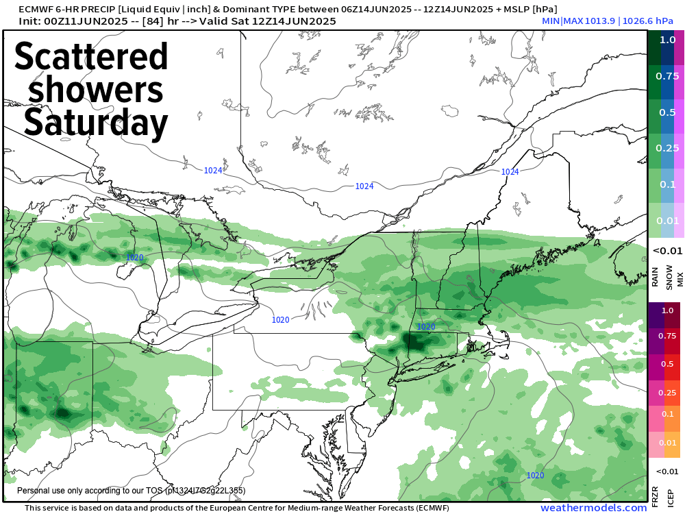
A couple of disturbances are likely to move through our flow this weekend. While I don’t think it will be raining all the time, we could have a couple-three periods of lighter rain showers, because at the moment I don’t see any real wash-out potential. It will be cooler as well, with highs only in the 65-70º range.
There are some sunnier signals for Monday, and beyond that we may be entering into a more persistent warm pattern with less of these temperature dips that have been brought about by departing yet nearby swipes of upper troughs connected to a weakening Polar Vortex well north of us in Canada.
The Solstice approaches.
For those saying Summer is over, I have news for you – it hasn’t even begun, so let’s see how things play out.
Have a great day!
“Follow your bliss and the universe will open doors for you where there were only walls.”
― Joseph Campbell