
TODAY’S NUTSHELL: Our upper low departs the region today but will still provide potential for a few isolated showers and periods of clouds and sun. Clouds should clear tonight, especially after midnight. The Earth is currently being buffeted by a strong to severe geomagnetic storm, and so Auroras in our region may be visible tonight and tomorrow night. Nautical twilight ends at 9:45pm tonight and begins at 4:00am tomorrow morning so that’s the window most absent of light interference, (especially between 1:00am-4:00am as the waxing crescent moon will be set). Fair weather is expected Monday through Thursday morning with sunshine and increasingly warm temps, and increasingly humid air by mid to late week. By Thursday afternoon into Friday some showers and thunderstorms are possible, and another area of rain is also possible by next weekend.
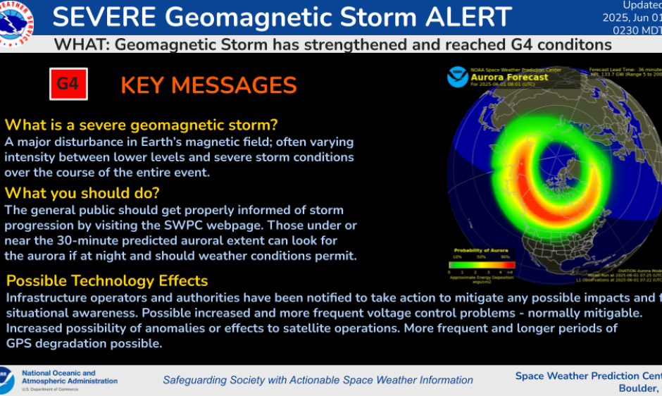
TABLE OF CONTENTS
* Daily Celestials (Sun/Moon Data)
* Sponsor Section
* Morning Discussion
~~~~~~~~~~~~~~~~~~~~~~
YOUR DAILY CELESTIALS
~~~~~~~~~~~~~~~~~~~~~~
STAR:
–OUR STAR ROSE AT: 5:16am this morning
–OUR STAR SETS AT: 8:20pm this evening
–TOTAL DAYLIGHT TIME: 15 hours and 4 minutes
MOON:
–OUR MOON RISES AT: 10:56am this morning
–MOON RISE DIRECTION: East-Northeast
–OUR MOON SETS AT: 1:09am tomorrow morning
–MOON SET DIRECTION: West-Northwest
–MOON PHASE: Waxing Crescent (33.7%)
~~~~~~~~~~~~~~~~~~~~~~
>>> A NOTE FROM OUR WEEKEND SPONSOR <<<
Dave Hayes The Weather Nut is Sponsored by Individual Community Members, Patrons, and Gerard, Ghazey & Bates, P.C.
GGBPC is a Northampton-based law firm and is the area’s premier estate and tax planning provider. The firm specializes in Estate Planning, Elder Law, and Tax Law, so be sure to contact GGBPC today to see how they can help you.
Simply click the following link to their secure website.
~~~~~~~~~~~~~~~~~~~~~~
YOUR MORNING DISCUSSION
~~~~~~~~~~~~~~~~~~~~~~
Good morning everybody, our weather is fairly pedestrian into the late week period, and generally features increasing sunshine, warmth, and humidity (that last part by mid to late week, especially).
And while I will get to that, there are two bigger weather stories to discuss and remember, one being Earth-bound, the other being Space-bound.
SPRING TORNADO 14TH ANNIVERSARY
Today is a very somber day as it is the 14th anniversary of the Springfield tornado which ripped through Hampden and southern Worcester County around dinner time on June 1, 2011, leaving a 39 mile long surface scar, killing 3 people, injuring 100s, and reaching F3 status near Monson into Brimfield where it exploded into to a half-mile wide monster, turning some areas into scenes out of Oklahoma and the southern Plains.
AURORA MAY BE VISIBLE OVERNGHT & MONDAY NIGHT
As far as our Space weather is concerned, we are being buffeted by a strong to severe geomagnetic storm, the result of which is caused first by a smaller earth-bound coronal mass ejection (CME), which is now being compressed by a much larger CME that was directly earth-facing.
NERD ALERT
The strong, severe, and extreme geomagnetic storm classifications are “G3 with a Kp=7”, “G4 with a Kp=8”, and “G5 with a Kp=9” respectively, and we are seeing G4 levels with a Kp of 8 currently (Kp is measurement of fluctuation of magnetic levels near/on Earth… the higher the number, the greater the storming effects, and once we get above Kp7, Aurora can become visible in WMass).
This is expected to continue today, tonight, tomorrow and tomorrow night, with the peak being expected on Monday and Monday night.
Space Weather is not my zone of competency, but in terms of Aurora visibility, we’re looking for optimum viewing times, should the Aurora form overhead.
Given the above, we know that the moon will set at 1:09am tomorrow morning, and it appears that our cloud deck will clear earlier than that, especially after midnight.
Also, Nautical Twilight begins at 9:45pm and ends at 4:00am (when it is actually dark after dusk and before dawn).
Because this geomagnetic storming is likely to increase tomorrow/Monday, if I had to choose tonight or tomorrow morning to view, I would get up before 4am, as there is a pretty strong likelihood that the Aurora will be visible, especially looking north, and storming is expected to increase into Monday.
Of course, I’m personally going to be looking tonight and tomorrow morning (and again tomorrow night when we should have pretty clear skies).
To repeat, this is not my area of expertise, and while this event is unlikely to achieve the level of the May 2024 aurora event when many of us saw it, chances are pretty good tonight and maybe even more so tomorrow night for the greater WMass region to see the Aurora!
OUR WEATHER FORECAST
As far as our weather is concerned, our upper low is departing the region today and as such should keep us cooler and may help bloom some clouds as the day wears, so call it a partly sunny day with areas of cloudiness. Westerly winds will gust 20-35mph and highs will reach the upper 50s to mid 60s with lows in the low to mid 40s as clouds break up.
Early Spring conditions kiss and wave goodbye through Monday with summer set to surge later this week.
Monday through Thursday looks mostly sunny with increasingly warm temperatures building from the mid 60s to low 70s Monday, to near 80º by Tuesday, and well into the 80s on Wednesday and Thursday. In fact a few spots may hit 90º in the Springfield to Hartford heat strip!
Lows will dip to the 40s Monday night, the 50s Tuesday night, and then the low to mid 60s by Wednesday and Thursday night.
Humidity will increase by Wednesday with dewpoints into the mid 60s, and then possibly hitting 70º by Thursday and Friday as a cold front approaches the region with the potential for showers and thunderstorms Thursday afternoon into Friday.
Thereafter, we could see yet another showery Saturday, but I’ll update on that we get closer.
Have a great day!
“Follow your bliss and the Universe will open doors for you where there were only walls.”
― Joseph Campbell