
TABLE OF CONTENTS
* Daily Celestials (Sun/Moon Data)
* Sponsor Note
* Morning Discussion
* TIP: Scroll below for sections, or read all
~~~~~~~~~~~~~~~
YOUR DAILY CELESTIALS
~~~~~~~~~~~~~~~~~~~~~~
STAR:
–OUR STAR ROSE AT: 6:39am this morning
–OUR STAR SETS AT: 7:11pm this evening
–TOTAL DAYLIGHT TIME: 12 hours and 32 minutes
MOON:
–OUR MOON ROSE AT: 6:14am this morning
–MOON RISE DIRECTION: East
–OUR MOON SETS AT: 6:29pm this afternoon
–MOON SET DIRECTION: West
–MOON PHASE: New Moon (1.5%)
~~~~~~~~~~~~~~~~~~~~~~
A NOTE FROM OUR SPONSOR
~~~~~~~~~~~~~~~~~~~~~~
Dave Hayes The Weather Nut is Sponsored by Individual Community Members, Patrons, and Tandem Bagel Company… No matter the weather, Tandem Bagel is always there for you at several valley locations to make your mornings brighter! With *New Pizza Bagels(!)*, along with bagels baked fresh daily (including Gluten-Free options), house-whipped cream cheese, coffee, and tons of lunch options, Tandem is the perfect quick stop for lunch, breakfast, or a coffee and bagel to go.
You can either 1) visit them in Easthampton, Northampton, Hadley, Florence, and/or West Springfield, 2) hire them to cater your next event, or 3) use their super-streamlined online ordering tool by visiting their website and clicking the “Catering” or “Order Online” links.
~~~~~~~~~~~~~~~~~~~~~~
YOUR MORNING DISCUSSION
~~~~~~~~~~~~~~~~~~~~~~
Good morning everybody, we have an elevated chance for fire spread today so mind your early Spring burns as westerlies will gust 15-30mph at times today.
Highs will climb into the upper 40s to mid to upper 50s for most of us from north to south under partly sunny skies as brief high pressure works into the region.
For tonight, clouds will increase as the clash between incoming warm air from the southwest meets up with colder air being driven south and southwest by high pressure to our north and northeast.
This clash will set up right over northern parts of the greater WMass region, and may push southward more into Massachusetts by Saturday evening and night before lifting northeast later Sunday and through Monday as a a storm and its cold front finally sweeps through by Monday night, clearing us out for Tuesday.
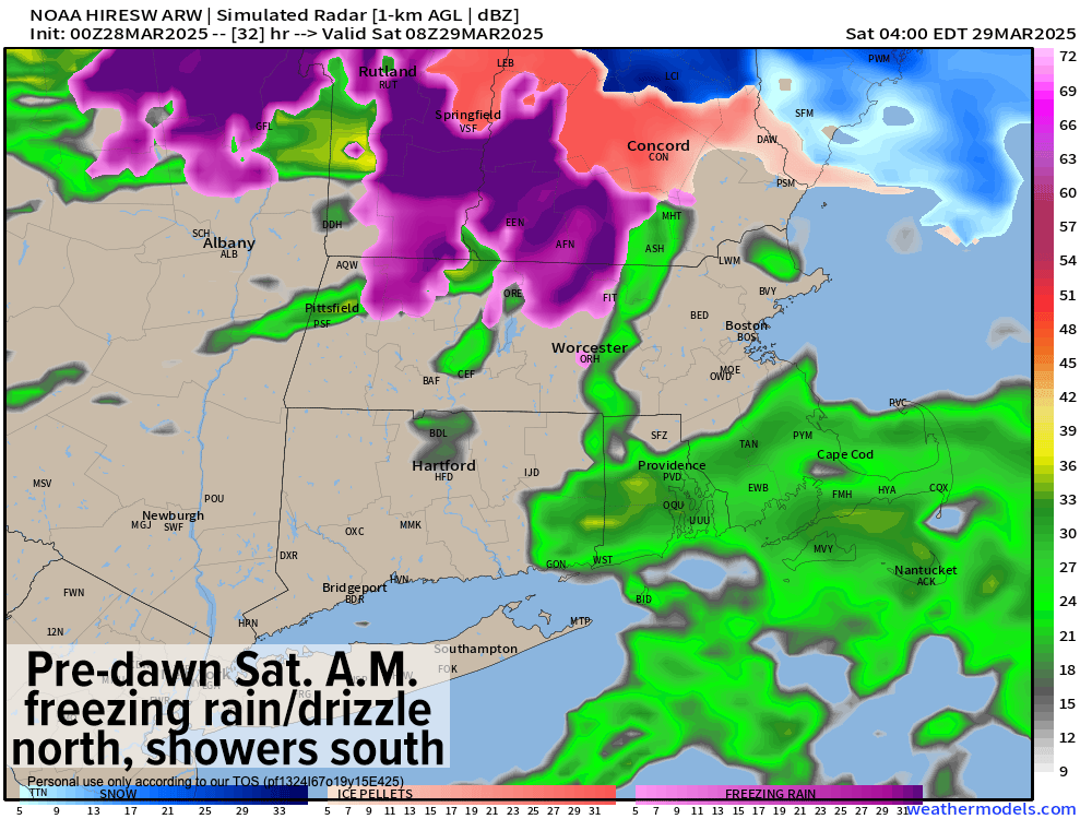
In other words, Saturday to Monday looks to feature periods of rain, drizzle, fog as well as a bit of snow in SVT/SWNH, but more in the way of sleet and especially freezing rain along and especially north of the Route 2 corridor.
For tonight, lows will drop into the 30s as the frontal boundary sets up and sags south for a time. This should focus periods of rain showers at times, moving west to east across our region. However, in southern VT and southwest NH and parts of far northern MA it should allow for some snow at first, but then sleet and/or freezing rain to develop.
Winter Weather Advisories are up for SVT, but that may expand into SWNH and possibly areas like the northern Berkshires, Franklin County and northern CMass, we shall see, as it is a very tricky forecast.
By early Saturday morning, we should already be seeing active icing in SVT and SWNH at the very least, but that may bleed south a bit into those aforementioned northern MA areas.
For Saturday, ripples of low pressure move along the front, but the most precip looks to be north of Route 2 during the day, leaving areas south of Rt. 2 to see more periods of dry weather (that will change Saturday night as the front sags south again!)
The temperature gradient will be wild across southern New England Saturday!! The warm front should make it northeast of southwest MA, in a line roughly from the northern Berkshires through about Northampton/Holyoke, southeast through eastern Hampden County into northeast CT to southern RI.
Southwest of that line (like north-central and northwest CT into the southern Berkshires and possibly even Springfield) temps will rise into the upper 50s to upper 60s, and possibly low 70s! Northeast out of that line, highs 35-50º!!
I will try to refine this by tomorrow morning, but it’s wackadoodle for sure. It’ll be drier south of Rt. 2 with a few showers, and continued periods of rain and/or freezing rain in southern VT and southwest NH, so while Hartford folks are taking the jackets off, folks in southern VT are trying not to slip and fall on the fresh ice!
The front sags south again later Saturday into Saturday night cooling most of us off, with freezing rain threat spreading into the northern half of MA, SVT and SWNH with periods of plain rain south of there and lows in the 30s.
On Sunday, the front should eventually bob north again, but that might not happen until late, or at night, so temps should be cooler across the board in the mid 30s to upper 40s from north to south with periods of showers or some icing well north, lasting into the night with lows in the 30s.
We get a brief break Monday morning, but then the storm to our north drags the warm front through with highs either side of 60º, and then it drags its cold front through by Monday night bringing more rainfall.
Fair weather moves in for Tuesday and Wednesday with cooler highs in the 40s, before more rain could move in by Thursday. I will update you again hopefully this evening, and certainly by Saturday morning.
Have a great day, and I hope something unexpectedly good happens to and for you today!
“Follow your bliss and the universe will open doors for you where there were only walls.”
― Joseph Campbell