
TABLE OF CONTENTS
* Daily Celestials (Sun/Moon Data)
* Sponsor Note
* Morning Discussion
* TIP: Scroll below for sections, or read all
~~~~~~~~~~~~~~~
YOUR DAILY CELESTIALS
~~~~~~~~~~~~~~~~~~~~~~
STAR:
–OUR STAR ROSE AT: 6:15am this morning
–OUR STAR SETS AT: 7:27pm this evening
–TOTAL DAYLIGHT TIME: 13 hours and 12 minutes
MOON:
–OUR MOON RISES AT: 6:25pm this evening
–MOON RISE DIRECTION: East
–OUR MOON SETS AT: 5:54am tomorrow morning
–MOON SET DIRECTION: West
–MOON PHASE: Waxing Gibbous (97.9%)
~~~~~~~~~~~~~~~~~~~~~~
A NOTE FROM OUR SPONSOR
~~~~~~~~~~~~~~~~~~~~~~
Dave Hayes The Weather Nut is Sponsored by Individual Community Members, Patrons, and Tandem Bagel Company… No matter the weather, Tandem Bagel is always there for you at several valley locations to make your mornings brighter! With *New Pizza Bagels(!)*, along with bagels baked fresh daily (including Gluten-Free options), house-whipped cream cheese, coffee, and tons of lunch options, Tandem is the perfect quick stop for lunch, breakfast, or a coffee and bagel to go.
You can either 1) visit them in Easthampton, Northampton, Hadley, Florence, and/or West Springfield, 2) hire them to cater your next event, or 3) use their super-streamlined online ordering tool by visiting their website and clicking the “Catering” or “Order Online” links.
~~~~~~~~~~~~~~~~~~~~~~
YOUR MORNING DISCUSSION
~~~~~~~~~~~~~~~~~~~~~~
Good morning folks, well well well the fun never stops until we come to end of not meteorological winter, and not astronomical winter, but Harvey-ological Winter!
WTH are you talking about, Dave? Well, it just so happens that the very snowstorm that piqued my interest in weather back on May 9-10, 1977 in EMass when we got 10” of wet snow and trees came down everywhere, was the first storm Meteorologist Harvey Leonard called for WHDH Channel 7 in Boston. Since that time, he coined that self-named term too indicate that until mid-May we can get accumulating snowstorms in southern New England.
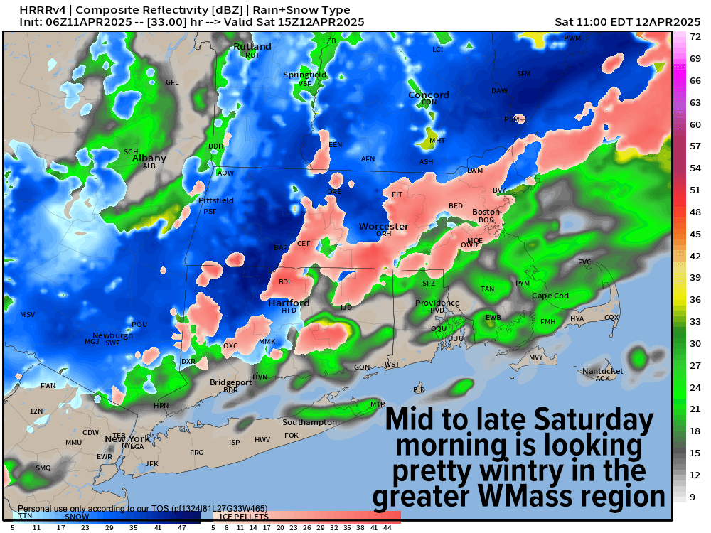
And here we are, waking up to coatings to a couple of inches this morning depending on where you are (let me know how much you got!) and now we’re staring down a repeat performance with even more wintry vim and vigor for late tonight through Saturday morning.
For this morning, any snow, sleet, rain or drizzle will wind down toward 10am-ish, and we’ll end up with a cool, mostly cloudy day with highs in the upper 30s to upper 40s for most of us, after starting off in the upper 20s to mid 30s.
For tonight, clouds thicken as a massive east coast trough pushes closer to us, helping to develop a surface low well south of New England and a closing-off upper low in the northern Mid-Atlantic region.
The surface low will hold the cold-enough air in place, and the upper low to our southwest will drive moister air from south to north, producing widespread lifting air across our region overnight, allowing precipitation to bloom, starting around midnight but really blossoming between about 3am onward.
The arrival of the precip at night, and the steadier/heavier nature of it should create dynamic cooling and turn any mixed precip over to snow or snow and sleet mix by dawn, producing accumulating snow in the high terrain through much of Saturday morning.
The valley should see a mix of rain, sleet and snow, but I also expect areas north of the CT/MA state line to snow with coatings to an inch or so in our low elevation areas of WMass and northernmost CT.
By noon tomorrow, a widespread 2-5” is expected in the Berkshires, western hilltowns, SVT and SWNH, with more like 1-3” in central/eastern Franklini County and northern Worcester County.
Lows should bottom out in the upper 20s to mid 30s with highs on Saturday in the 30s to near 40º.
Please note that some areas in the western high terrain of MA and VT could see up to one inch per hour snow rates, so even some roads may become slippery, even though we have a high sun angle this time of year and temps will be marginal, meaning more roads should be wet than white, but watch for early morning travel, and periods of any heavier snow for slippery conditions.
By Saturday night, the storm winds down and lows will bottom out into the low to mid 30s with some rain showers Sunday in parts of CMass and northeast CT with highs in the 40s to low 50s, and lows Sunday night in the low to mid 30s.
By Monday we warm into the 60s and will see sunshine return, so the gloom won’t last forever.
By Tuesday another front will pass through with more rain showers and the potential behind that front (if the Canadian storm its draped off of is strong enough) is for strong westerly winds to gust by Tuesday night or Wednesday with a brief cool snap and potential for lake effect snow showers into the Berkshires Wednesday night.
By late next week temps should come back up but there is another signal for more rain by Friday/Saturday, so I will keep you updated on all of it!
Have a great day!
“Follow your bliss and the universe will open doors for you where there were only walls.”
― Joseph Campbell