
TABLE OF CONTENTS
* Daily Celestials (Sun/Moon Data)
* Sponsor Note
* Morning Discussion
* TIP: Scroll below for sections, or read all
~~~~~~~~~~~~~~~
YOUR DAILY CELESTIALS
~~~~~~~~~~~~~~~~~~~~~~
STAR:
–OUR STAR ROSE AT: 6:19am this morning
–OUR STAR SETS AT: 7:25pm this evening
–TOTAL DAYLIGHT TIME: 13 hours and 6 minutes
MOON:
–OUR MOON RISES AT: 4:21pm this afternoon
–MOON RISE DIRECTION: East
–OUR MOON SETS AT: 5:19am tomorrow morning
–MOON SET DIRECTION: West
–MOON PHASE: Waxing Gibbous (88.7%)
~~~~~~~~~~~~~~~~~~~~~~
A NOTE FROM OUR SPONSOR
~~~~~~~~~~~~~~~~~~~~~~
Dave Hayes The Weather Nut is Sponsored by Individual Community Members, Patrons, and Tandem Bagel Company… No matter the weather, Tandem Bagel is always there for you at several valley locations to make your mornings brighter! With *New Pizza Bagels(!)*, along with bagels baked fresh daily (including Gluten-Free options), house-whipped cream cheese, coffee, and tons of lunch options, Tandem is the perfect quick stop for lunch, breakfast, or a coffee and bagel to go.
You can either 1) visit them in Easthampton, Northampton, Hadley, Florence, and/or West Springfield, 2) hire them to cater your next event, or 3) use their super-streamlined online ordering tool by visiting their website and clicking the “Catering” or “Order Online” links.
~~~~~~~~~~~~~~~~~~~~~~
YOUR MORNING DISCUSSION
~~~~~~~~~~~~~~~~~~~~~~
Good morning folks, as it turns out winds have gusted 25-40mph since midnight, which has driven wind chills down into the single digits, teens and 20s overnight. Air temps dropped into the 20s and low 30s, with a few upper teens noted in northwest MA and SVT.
Currently, gusts are hitting 25mph at times, but as the Sun comes up into the mid morning we could see wind gust back up over 30mph at times before slackening later this afternoon.
Highs will reach the mid 30s-mid 40s under mostly sunny skies as high pressure noses in from the west, destined to pass south of us and south of Nantucket by Thursday.
Lows tonight will dip into the upper teens to mid 20s for one more cold night before we begin a multi-day slow climb into the low to mid 60s by early/mid next week.
Partly sunny skies will develop as a warm front tracks toward our greater WMass region Thursday with highs in the 40s to low 50s, as clouds increase late in the day.
Overnight, some scattered snow and rain showers will develop with lows in the low to mid 30s, ending sometime on Friday morning.
For Friday, we’ll dry out briefly, but with high pressure positioned north and northeast of us, and with low pressure developing to the south of New England in response to an upper trough deepening near the central/southern Appalachians, clouds will rebuild later as highs crest into the 40s to low 50s, similarly to Thursday.
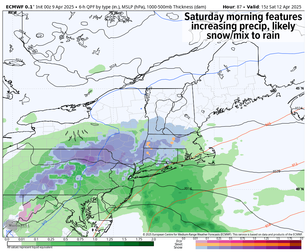
For Friday night, clouds thicken as low pressure deepens to our south and pushes a mixi of snow and rain northward from south of New England into the greater WMass region with lows in the 30s.
This precip should be more rain than snow, but in the high terrain as precip becomes steadier/heavier, dynamic cooling may produce wet snow for a time, so something I’ll be watching.
Wet weather should carry into Saturday with highs only in the mid 30s to mid 40s, so another raw, damp Saturday looks to be queued up.
Beyond that, there’s some uncertainty with a third system that may develop off the coast and push more showers in here late Saturday night into Sunday, so I will have to parse that out some more and get back to you in later reports.
Highs will be milder on Sunday, well into the 40s to low 50s, and by early next week some fair weather looks to develop as these storm systems pull away from our region, allowing high temps to rise into the low 60s, so there’s light (and warmth) at the end of the damp, dreary tunnel!
Have a great day!
“Follow your bliss and the universe will open doors for you where there were only walls.”
― Joseph Campbell