
TODAY’S NUTSHELL: Good morning folks, the storm track continues to be to our north and that means more warm-front-cold-front combos with warming and cooling temps along with some showers and storms, and a longer rainy period Saturday into Saturday night, tapering off Sunday morning.
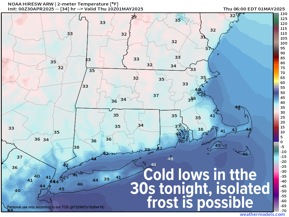
TABLE OF CONTENTS
* Daily Celestials (Sun/Moon)
* Sponsor Section
* Your Short-Term ZoneCast
* Morning Discussion
~~~~~~~~~~~~~~~
YOUR DAILY CELESTIALS
~~~~~~~~~~~~~~~~~~~~~~
STAR:
–OUR STAR ROSE AT: 5:47am this morning
–OUR STAR SETS AT: 7:48pm this evening
–TOTAL DAYLIGHT TIME: 14 hours and 1 minute
MOON:
–OUR MOON RISES AT: 7:27am this morning
–MOON RISE DIRECTION: Northeast
–OUR MOON SETS AT: 11:59pm tonight
–MOON SET DIRECTION: Northwest
–MOON PHASE: Waxing Crescent (10 .4%)
~~~~~~~~~~~~~~~~~~~~~~
A NOTE FROM OUR SPONSOR
~~~~~~~~~~~~~~~~~~~~~~
Dave Hayes The Weather Nut is Sponsored by Individual Community Members, Patrons, and Tandem Bagel Company… No matter the weather, Tandem Bagel is always there for you at several valley locations to make your mornings brighter! With *New Pizza Bagels(!)*, along with bagels baked fresh daily (including Gluten-Free options), house-whipped cream cheese, coffee, and tons of lunch options, Tandem is the perfect quick stop for lunch, breakfast, or a coffee and bagel to go.
You can either 1) visit them in Easthampton, Northampton, Hadley, Florence, and/or West Springfield, 2) hire them to cater your next event, or 3) use their super-streamlined online ordering tool by visiting their website and clicking the “Catering” or “Order Online” links.
~~~~~~~~~~~~~~~~~~~~~~
YOUR SHORT-TERM ZONECAST
~~~~~~~~~~~~~~~~~~~~~~
ZONE 1 – Northern Region
(Southern VT, Southwest NH)
–Highs Today: Upper 50s to Mid 60s
–Lows Tonight: Low to Mid 30s
–Highs Tomorrow: Mid to Upper 60s
–Winds: NW gusts 20-30mph today, slackening tonight and tomorrow
–Skies: Becoming sunny today, mostly clear tonight, mostly sunny tomorrow
–Precip: None
–NWS Alerts + Nut Notes: Elevated risk of fire spread, especially this A.M.
ZONE 2 – Central Region
(Western MA, North-Central MA, Northern Litchfield CT)
–Highs Today: Mid 60s
–Lows Tonight: Low to Mid 30s
–Highs Tomorrow: Upper 60s to Low 70s
–Winds: NW gusts 20-30mph today, slackening tonight and tomorrow
–Skies: Becoming sunny today, mostly clear tonight, mostly sunny tomorrow
–Precip: None
–NWS Alerts + Nut Notes: Elevated risk of fire spread, especially this A.M.
ZONE 3 – Southern Region
(South-Central MA, Northern CT)
–Highs Today: Mid to Upper 60s
–Lows Tonight: Upper 30s to Low 40s
–Highs Tomorrow: Upper 60s to Low 70s
–Winds: NW gusts 20-30mph today, slackening tonight and tomorrow
–Skies: Becoming sunny today, mostly clear tonight, mostly sunny tomorrow
–Precip: None
–NWS Alerts + Nut Notes: Elevated risk of fire spread, especially this A.M.
~~~~~~~~~~~~~~~~~~~~~~
YOUR MORNING DISCUSSION
~~~~~~~~~~~~~~~~~~~~~~
Good morning everybody, I’m feeling under the weather today, so this report will be fairly short.
For today, clouds will break up with time bringing more sun to our skies, while northwest gusts usher in cooler air. Gusts will reach the 20-30mph range with highs in the 60s for most of us (some upper 50s are expected in SVT).
The Calmening will commence later today and tonight as high pressure moves closer to the region, and this will help with mostly clear skies to maximize radiational cooling.
Patchy frost is probable tonight, as lows dip into the low to mid 30s north of the Pike, and the mid 30s to low 40s south of the Pike.
For Thursday, we should enjoy mostly sunny skies for much of the day before clouds build later on our Thursday. Highs will reach the mid 60s to low 70s, and then by nightfall I’ll be watching a warm front approaching the region which should push some showers in late at night, with some embedded thunder and downpours possible into the pre—dawn or early post-dawn hours of Friday morning.
Friday looks warm and mostly cloudy with highs well into the 70s, along with a chance for afternoon showers and storms. Lows will dip into the 50s.
The weekend is looking unsettled at this point, with perhaps some potential for Sunday afternoon sunny breaks.
Otherwise, a frontal boundary will be pressing into our region by mid-day Saturday with copious amounts of showers Saturday afternoon, night, and possibly lingering into Sunday morning.
Highs will reach the 70s on Saturday, but should hang in the 60s for highs on Sunday behind the cold front.
Early to mid next week also holds some potential for wet weather, but I will dial that in as we get closer, and will continue to dial in our Thursday night to Sunday morning time period with two to three bouts of rainfall expected.
Have a great day!
“Follow your bliss and the universe will open doors for you where there were only walls.”
― Joseph Campbell