
TODAY’S NUTSHELL: Good morning folks, we are set to rocket through the 70s into the low 80s for some today under sunny skies. Gusty southwest winds to 35mph later today will increase chance for fire spread so mind your butts’n’burns! Showers and storms move through 8pm-2am tonight with fair and cooler weather to follow through Thursday by which time more showers are possible on and off from Thursday night through Saturday night, with Sunday as the weekend pick.
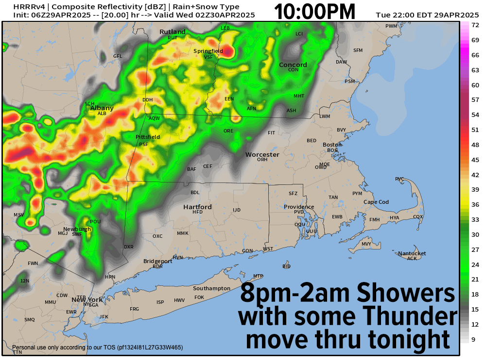
TABLE OF CONTENTS
* Daily Celestials (Sun/Moon)
* Sponsor Section
* Your Short-Term ZoneCast
* Morning Discussion
~~~~~~~~~~~~~~~
YOUR DAILY CELESTIALS
~~~~~~~~~~~~~~~~~~~~~~
STAR:
–OUR STAR ROSE AT: 5:48am this morning
–OUR STAR SETS AT: 7:47pm this evening
–TOTAL DAYLIGHT TIME: 13 hours and 59 minutes
MOON:
–OUR MOON ROSE AT: 6:37am this morning
–MOON RISE DIRECTION: Northeast
–OUR MOON SETS AT: 10:48pm tonight
–MOON SET DIRECTION: Northwest
–MOON PHASE: Waxing Crescent (4.3%)
~~~~~~~~~~~~~~~~~~~~~~
A NOTE FROM OUR SPONSOR
~~~~~~~~~~~~~~~~~~~~~~
Dave Hayes The Weather Nut is Sponsored by Individual Community Members, Patrons, and Tandem Bagel Company… No matter the weather, Tandem Bagel is always there for you at several valley locations to make your mornings brighter! With *New Pizza Bagels(!)*, along with bagels baked fresh daily (including Gluten-Free options), house-whipped cream cheese, coffee, and tons of lunch options, Tandem is the perfect quick stop for lunch, breakfast, or a coffee and bagel to go.
You can either 1) visit them in Easthampton, Northampton, Hadley, Florence, and/or West Springfield, 2) hire them to cater your next event, or 3) use their super-streamlined online ordering tool by visiting their website and clicking the “Catering” or “Order Online” links.
~~~~~~~~~~~~~~~~~~~~~~
YOUR SHORT-TERM ZONECAST
~~~~~~~~~~~~~~~~~~~~~~
ZONE 1 – Northern Region
(Southern VT, Southwest NH)
–Highs Today: Mid to Upper 70s
–Lows Tonight: Upper 40s to Low 50s
–Highs Tomorrow: Upper 50s to Mid 60s
–Winds: SW gusts 20-35mph today and tonight, NW gusts 20-30mph tomorrow
–Skies: Mostly sunny today, mostly cloudy tonight, mostly sunny tomorrow
–Precip: Dry today, showers/t-storms 8pm-Midnight tonight, dry tomorrow
–NWS Alerts + Nut Notes: Elevated risk of fire spread today, be mindful
ZONE 2 – Central Region
(Western MA, North-Central MA, Northern Litchfield CT)
–Highs Today: 70s to Low 80s
–Lows Tonight: Upper 40s to Mid 50s
–Highs Tomorrow: Upper 50s to Mid 60s (some upper 60s lower valley)
–Winds: SW gusts 20-35mph today and tonight, NW gusts 20-30mph tomorrow
–Skies: Mostly sunny today, mostly cloudy tonight, mostly sunny tomorrow
–Precip: Dry today, showers/t-storms 9pm-1am tonight, dry tomorrow
–NWS Alerts + Nut Notes: Elevated risk of fire spread today, be mindful
ZONE 3 – Southern Region
(South-Central MA, Northern CT)
–Highs Today: 70s to Low 80s
–Lows Tonight: Low to Mid 50s
–Highs Tomorrow: Mid to Upper 60s
–Winds: SW gusts 20-35mph today and tonight, NW gusts 20-30mph tomorrow
–Skies: Mostly sunny today, mostly cloudy tonight, mostly sunny tomorrow
–Precip: Dry today, showers 10pm-2am tonight, dry tomorrow
–NWS Alerts + Nut Notes: Elevated risk of fire spread today, be mindful
~~~~~~~~~~~~~~~~~~~~~~
YOUR MORNING DISCUSSION
~~~~~~~~~~~~~~~~~~~~~~
Good morning everybody, we’ve got a large area of high pressure south of New England with a decently-strong low north of the Great Lakes tracking NE into Canada, which will produce a decent pressure gradient across the region today.
With high pressure dominating today’s weather, the low and the high will produce southwest low and increasing wind gusts of 20-35mph later today and tonight under full sunshine which will drive highs through the 70s, with some low 80s possible in the southern valley.
This will also enable a cold front to be dragged through the region tonight, and will result in a weakening line of showers and thunderstorms moving through between 8pm (southwest VT) to 2am (northeast CT into CMass) with the valley getting activity about 10pm to 1am, give or take.
Some storms may be strong in southwest VT, but they should be weakening as they track east overnight, as lows drop into the upper 40s to mid 50s.
Behind the front tomorrow, full sunshine redevelops with a northwest breeze gusting up to 30mph at times.
Between today and tomorrow (especially today) there is an elevated risk of fire spread, so mind your butts’n’burns, party people.
Highs tomorrow will only be in the upper 50s to upper 60s from north to south behind the front, and lows will dip into the upper 30s to low 40s under clear skies.
For Thursday, winds will be calmer and sunshine should abound with highs in the 65-70º range with clouds building into the region late in the day.
A series of frontal boundaries will move through our flow Thursday night through Saturday night before we can bust a move into more sunshine by Sunday and Monday with highs in the 60s at that time (and lows in the 40s).
By Thursday night, a warm front will bring a few showers through with lows either side of 50º, leading to a very warm Friday with highs well through the 70s to near 80º.
However, it looks mostly cloudy, with additional periods of showers by latter Friday afternoon into the night.
Saturday morning may feature a lull in the action, but by afternoon and evening into the night, we could see substantial rainfall (as compared to the showery periods Thursday night and Friday night), so I will keep you updated on timing and impacts of that period as we get closer.
Have a great day!
“Follow your bliss and the universe will open doors for you where there were only walls.”
― Joseph Campbell