
TABLE OF CONTENTS
* Daily Celestials (Sun/Moon Data)
* Sponsor Note
* Morning Discussion
* TIP: Scroll below for sections, or read all
~~~~~~~~~~~~~~~
YOUR DAILY CELESTIALS
~~~~~~~~~~~~~~~~~~~~~~
STAR:
–OUR STAR ROSE AT: 6:10am this morning
–OUR STAR SETS AT: 7:30pm this evening
–TOTAL DAYLIGHT TIME: 13 hours and 20 minutes
MOON:
–OUR MOON SET AT: 6:35am this morning
–MOON SET DIRECTION: West-Southwest
–OUR MOON RISES AT: 9:33pm this evening
–MOON RISE DIRECTION: East-Southeast
–MOON PHASE: Waning Gibbous (98.1%)
~~~~~~~~~~~~~~~~~~~~~~
A NOTE FROM OUR SPONSOR
~~~~~~~~~~~~~~~~~~~~~~
Dave Hayes The Weather Nut is Sponsored by Individual Community Members, Patrons, and Tandem Bagel Company… No matter the weather, Tandem Bagel is always there for you at several valley locations to make your mornings brighter! With *New Pizza Bagels(!)*, along with bagels baked fresh daily (including Gluten-Free options), house-whipped cream cheese, coffee, and tons of lunch options, Tandem is the perfect quick stop for lunch, breakfast, or a coffee and bagel to go.
You can either 1) visit them in Easthampton, Northampton, Hadley, Florence, and/or West Springfield, 2) hire them to cater your next event, or 3) use their super-streamlined online ordering tool by visiting their website and clicking the “Catering” or “Order Online” links.
~~~~~~~~~~~~~~~~~~~~~~
YOUR MORNING DISCUSSION
~~~~~~~~~~~~~~~~~~~~~~
Good morning folks, while we’re never totally out of the wintry woods completely until about early to mid May in these parts (especially the hilltowns), I think you can put away the snow gear, lest you live in southern VT, and by next week you can probably do the same there, too.
More signals in the northeast U.S. of upper ridging (higher pressures aloft leading to milder air at the surface) are starting to fill our future vs. upper troughing (lower pressures aloft leading to cooler air at the surface, like we just had this weekend, and will again on Wednesday though not as strong).
As for the dailies, today looks like quite the reward for enduring this late-season wintry weekend through which we just moved.
Mostly sunny skies, highs in the upper 50s to upper 60s will be quite the improvement over snow accumulations up to 9” and highs in the 30s like we saw Saturday!
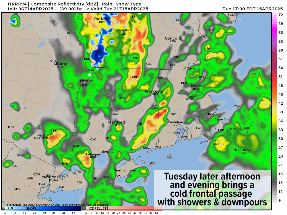
For tonight, a warm front will work through the region with lows hanging in the 40s with some scattered showers developing, more numerous south of the Pike into northern CT.
For Tuesday, after another round of showers likely moves through in the morning, we’ll then have to see how much sunshine we can develop which will help impact the convective nature of cold frontal precip moving in for Tuesday evening.
The greater the sunny breaks / periods we see by Tuesday early to mid-afternoon, the more we’d heat the surface.
The more we could heat the surface, the greater the chances that the cold front swinging into the region by late Tuesday afternoon and early could produce some convective downpours or even a thunderstorm or two containing small hail or graupel, given the unstable air profile with the front due to very cold air aloft (a/k/a “lapse rates”).
For now, highs Tuesday look to reach the 50s to low 60s, but we’ll see if sunshine bumps those up a bit more by Tuesday afternoon.
Showers, downpours, and a couple of thunderstorms move through late in the afternoon and evening, and then wind should develop at night into Wednesday, gusting 25-40mph out of the west, with lows Tuesday night in the 30s.
As this colder air mass moves in for about 36 hours with a weaker upper trough associated with it, some lake effect and/or upslope snow showers will develop into the Berkshires, western hilltowns and SVT, and could drop a coating to an inch or two by Wednesday noon, lasting into Wednesday morning, especially for the northern Berkshires into the southern Green Mountains.
Highs will only reach the upper 30s to upper 40s Wednesday with lows in the 30s.
By late week, high pressure builds back in with sunshine both days, and highs in the mid 40s to mid 50s Thursday with breezy conditions (lows in the 30s), and then Friday sees highs in the mid 50s to low 60s.
By Friday night into Saturday, some showers will redevelop, but Saturday looks warm with highs well into the 60s, maybe hitting 70º.
We’ll cool back down on Sunday, but only in the 50s, so I think we’re starting to move the Spring needle in the right direction.
Hang in there winter weary peeps and have a great day!
“Follow your bliss and the universe will open doors for you where there were only walls.”
― Joseph Campbell