
TABLE OF CONTENTS
* Daily Celestials (Sun/Moon Data)
* Sponsor Section
* Morning Discussion
* TIP: Scroll to your section, or read more
~~~~~~~~~~~~~~~~~~~~~~
YOUR DAILY CELESTIALS
~~~~~~~~~~~~~~~~~~~~~~
STAR:
–OUR STAR ROSE AT: 6:14am this morning
–OUR STAR SETS AT: 7:28pm this evening
–TOTAL DAYLIGHT TIME: 13 hours and 14 minutes
MOON:
–OUR MOON RISES AT: 7:26pm this evening
–MOON RISE DIRECTION: East-Southeast
–OUR MOON SETS AT: 6:13am tomorrow morning
–MOON SET DIRECTION: West-Southwest
–MOON PHASE: Full Pink Moon (99.7%)
~~~~~~~~~~~~~~~~~~~~~~
>>> A NOTE FROM OUR WEEKEND SPONSOR <<<
Dave Hayes The Weather Nut is Sponsored by Individual Community Members, Patrons, and Gerard, Ghazey & Bates, P.C.
GGBPC is a Northampton-based law firm and is the area’s premier estate and tax planning provider. The firm specializes in Estate Planning, Elder Law, and Tax Law, so be sure to contact GGBPC today to see how they can help you.
Simply click the following link to their secure website.
~~~~~~~~~~~~~~~~~~~~~~
YOUR MORNING DISCUSSION
~~~~~~~~~~~~~~~~~~~~~~
Good morning folks, I suppose April is the new March! I’ve received reports from around an inch of snow up to 7” of snow so far across the region, with manyu in the 2-4” range as the steadiest snow is winding down, except for northwestern MA into SVT/SWNH.
I had mentioned in my 10pm post last night that this system could overperform in terms of snow totals with some folks getting over half a foot, and that appears to have come to pass. By early afternoon we’ll get final totals from the western hillltowns, Berkshires and SVT and I suspect we’ll see some 5-9” totals there.
In addition, the “deformation zone” (an area of diverging air which forms in winter storms on the northwest flanks of their precipitation shields and vacuums air from surface to sky, causing heavy snow) set up over southern Berkshires into the Taconics. Heavy snow was also noted in CMass and other parts of WMass, with over an inch per hour snow rates.
We’re already seeing the drier air punch pushing north to the MA/CT-RI state line and that will continue to slowly lift north this morning, causing some areas to turn to freezing or regular drizzle, or scattered mixed precip showers with sleet, snow and/or rain.
High temps will only reach the 30s today, and northeast winds will gust up to 25mph at times, so a wintry day lies ahead with scattered light rain, mix or snow (or drizzle) as most totals come in around the 2-5” range, with swaths of high-terrain 5-8” amounts and coatings to up to 2” or so in the CT River Valley from about Northampton southward to Hartford and east through much of northern CT (except for parts of northern Litchfield County which should land in a 2-6” range depending on elevation).
For tonight, patchy drizzle (some of which may be freezing, so watch your temps) and a few mixed rain or snow showers are possible with lows in the low to mid 30s, with a potential surprise for later pre-dawn hours east of the I-91 corridor in far eastern Hampden/Hampshire Counties, northeast CT and CMass.
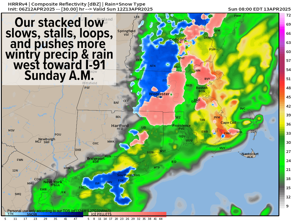
Our storm today is basically the most classically winter set up we had all winter! An upper trough resides west of us, and it captured a developing surface low off of the DelMarVA Peninsula near Delaware, and that has produced a “stacked low”, which in parts slows it down.
This low is now going to meander slowly northeast towards southeast MA today and tonight and may be invigorated by another wave that casts another round of wintry mixed precipitation in the form of snow, sleet and rain WESTWARD toward the I-91 corridor in the later pre-dawn hours into Sunday morning.
This may create another round of wintry weather with some slippery spots, so I will keep tabs on this trend and report later on its potential, but if you live east of I-91 (especially well east), Sunday morning may provide minor impacts (precip should be lighter than today).
Any early morning mixed wintry precip would go to rain showers and then wind down by afternoon as that system pulls east and away, with highs in the 40s, and lows Sunday night in the low to mid 30s.
Monday will be the pick of the week with mostly sunny skies and highs in the low 50s to low 60s from north to south, but clouds will increase Monday night as another front moves in with some light showers.
Tuesday looks showery, with improving conditions by afternoon with highs reaching the low 50s to low 60s again, and then a cold front will move through cooling us down into the upper 20s to mid 30s Tuesday night, with some Berkshire / SVT lake effect snow showers possible.
Wednesday looks windy at the moment, with gusts 25-40mph and highs in the 40s under partly sunny skies and lows in the 30s.
Some late week showers are possible by Friday, but no big storms appear to be in sight, and hopefully (as much as I love snow) this is the last wintry weekend before we more fully enter Spring.
IF YOU HAD WANTED TO…
And for folks who wanted to contribute this year to support my work but didn’t yet get a chance to, your contributions all go to keeping me on the job for you and yours, and towards helping me with my mobile app, which about 98% of the way to release (support link here)
Safe travels to all, and please let me know how much snow you got and posts some snowy pics if you got ‘em! Thanks!
“Follow your bliss and the Universe will open doors for you where there were only walls.”
― Joseph Campbell