TABLE OF CONTENTS
* Daily Celestials (Sun/Moon Data)
* Sponsor Note
* Morning Discussion
* TIP: Scroll below for sections, or read all
~~~~~~~~~~~~~~~
YOUR DAILY CELESTIALS
~~~~~~~~~~~~~~~~~~~~~~
STAR:
–OUR STAR ROSE AT: 6:32am this morning
–OUR STAR SETS AT: 7:16pm this evening
–TOTAL DAYLIGHT TIME: 12 hours and 44 minutes
MOON:
–OUR MOON ROSE AT: 8:04am this morning
–MOON RISE DIRECTION: East-Northeast
–OUR MOON SETS AT: 11:56pm tonight
–MOON SET DIRECTION: Northwest
–MOON PHASE: Waxing Crescent (13.2%)
~~~~~~~~~~~~~~~~~~~~~~
A NOTE FROM OUR SPONSOR
~~~~~~~~~~~~~~~~~~~~~~
Dave Hayes The Weather Nut is Sponsored by Individual Community Members, Patrons, and Tandem Bagel Company… No matter the weather, Tandem Bagel is always there for you at several valley locations to make your mornings brighter! With *New Pizza Bagels(!)*, along with bagels baked fresh daily (including Gluten-Free options), house-whipped cream cheese, coffee, and tons of lunch options, Tandem is the perfect quick stop for lunch, breakfast, or a coffee and bagel to go.
You can either 1) visit them in Easthampton, Northampton, Hadley, Florence, and/or West Springfield, 2) hire them to cater your next event, or 3) use their super-streamlined online ordering tool by visiting their website and clicking the “Catering” or “Order Online” links.
~~~~~~~~~~~~~~~~~~~~~~
YOUR MORNING DISCUSSION
~~~~~~~~~~~~~~~~~~~~~~
Good morning everybody, remember to do your FaceYoga™ (it’s not really trademarked) and raise those eyebrows (up for 3 seconds, down for 3 seconds, up for 3 seconds) while donning on a slightly dumb smile and see if you can let it widen as you go up/down 10 times to a real one.
THEN think about your problems, battles, challenges for the day. It might help move the needle in a more positive direction by 3%, and that’s better than 0%, if you ask me.
As for our weather, we got rocked and rolled a bit in Litchfield and Hartford Counties CT and into Hampden County MA last night as a strong thunderstorm was able to maintain its strength for a bit before washing into the general stratiform heavy rainfall that was drawn through the region by our passing cold frontal boundary.
As I mentioned yesterday, rainfall amounts were heavier the further south and east you went, generally a third to three-quarters of an inch along and southeast of a line from Great Barrington to Northampton MA up to eastern Cheshire county in the Monadnock Region of NH, with less than that north and west (Somers, CT saw over an inch of rain).
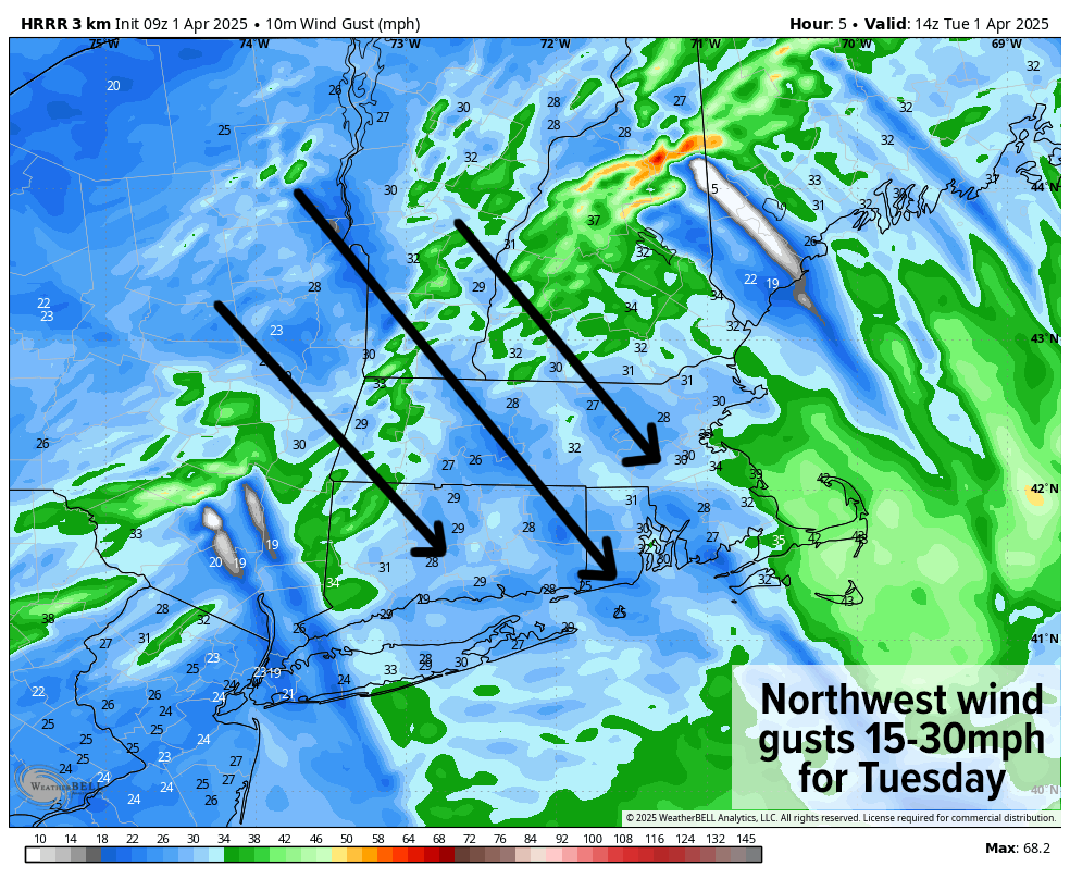
For today, clouds will be clearing and sunshine will be developing as much drier air moves into the region with high pressure to our northwest, helping induce northwest winds gusting 15-30mph today.
Highs will reach the upper 30s to upper 40s with wind chills at times in the 30s today. Wind should slacken tonight and help to increase radiational cooling, driving lows down into the upper teens to mid 20s under mostly clear skies.
Wednesday will feature partly to mostly sunny skies as surface high pressure and upper ridging shifts east of New England. Highs should again only make it up to the upper 30s to upper 40s with clouds developing late.
Yet another storm will be passing northwest of us on Thursday, which means a warm front will be floated our way Wednesday night, and with lows expected to drop into the upper 20s to mid 30s, we’ll likely see some mixed snow, sleet and freezing rain north of the Pike, especially near Route 2 on north into northern MA, SVT and SWNH late Wednesday night.
Some minor wintry precip impacts are possible in the pre-dawn hours of Thursday morning, but this should be a lighter system. Everybody turns to rain Thursday morning, with light rain ending by early afternoon with highs at least in the 50s, and possibly the low 60s for some. Thursday night lows dip into the 40s as we dry out.
A few showers are possible with a cold frontal passage Friday, but partly sunny skies on average are expected with highs in the 50s to low 60s, and lows dropping into the mid 30s to low 40s.
As of this writing, the weekend looks unsettled with two periods of precipitation, one on Saturday afternoon into evening, and another Sunday night into Monday morning.
Highs should generally be in the 40s to low 50s Saturday, and a bit milder on Sunday. However, a cold front will be moving into the region by very early Monday morning, and that could flip some of us from rain to snow for the Monday morning commute, so I will keep you updated as we get closer!
Have a great day!
“Follow your bliss and the universe will open doors for you where there were only walls.”
― Joseph Campbell
