TABLE OF CONTENTS
* Daily Celestials (Sun/Moon Data)
* Sponsor Note
* Join My Newsletter
(& get my Top12WMassStorms ebook!)
* Morning Discussion
* TIP: Scroll below for sections, or read all
~~~~~~~~~~~~~~~~~~~~~~
YOUR DAILY CELESTIALS
~~~~~~~~~~~~~~~~~~~~~~
STAR:
–OUR STAR ROSE AT: 5:49am this morning
–OUR STAR WILL SET AT: 8:02pm this evening
–TOTAL DAYLIGHT TIME: 14 hours and 13 minutes
MOON:
–OUR MOON WILL SET AT: 9:19pm tonight
–MOON SET DIRECTION: West
–OUR MOON WILL RISE AT: 8:49am tomorrow morning
–MOON RISE DIRECTION: East
–MOON PHASE: Waxing Crescent (3.9%)
~~~~~~~~~~~~~~~~~~~~~~
A NOTE FROM OUR SPONSOR
~~~~~~~~~~~~~~~~~~~~~~
Dave Hayes The Weather Nut is Sponsored by Individual Community Members, Patrons, and Tandem Bagel Company… No matter the weather, Tandem Bagel is always there for you at several valley locations to make your mornings brighter! With *New Pizza Bagels(!)*, along with bagels baked fresh daily (including Gluten-Free options), house-whipped cream cheese, coffee, and tons of lunch options, Tandem is the perfect quick stop for lunch, breakfast, or a coffee and bagel to go.
You can either 1) visit them in Easthampton, Northampton, Hadley, Florence, and/or West Springfield, 2) hire them to cater your next event, or 3) use their super-streamlined online ordering tool by visiting their website and clicking the “Catering” or “Order Online” links.
~~~~~~~~~~~~~~~~~~~~~~
DAVE’S WEEKLY NEWSLETTER (Top 12 WMass Storms)
DAVE’S MOBILE APP (Late 2024 Release)
~~~~~~~~~~~~~~~~~~~~~~
YOUR MORNING DISCUSSION
~~~~~~~~~~~~~~~~~~~~~~
Good morning everybody, the heat of the 2024 season has finally been broken.
That doesn’t mean we won’t see additional hot periods into September, but as we approach the second week of August, and as the light starts to head to under 14 hours per day, the clock is ticking at this point.
Highs over the next 7 days look to range between 70-80º with more lows down into the 50s.
In addition, after a very humid today and tonight, along with a tropical-system induced surge of high humidity Friday through Saturday night (with lows in the low/mid 60s), we’re also starting to work in lower dewpoints and decreased humidity.
As far as our sensible weather is concerned, we’ve got periods of scattered showers this morning and it’s still quite humid with patchy fog that will burn off with time.
A damp morning will lead to a drier afternoon with highs in the low to mid 70s with mostly cloudy skies and a few afternoon sunny breaks.
Clouds increase tonight as a cold front settles near or just south of the southern New England coastline.
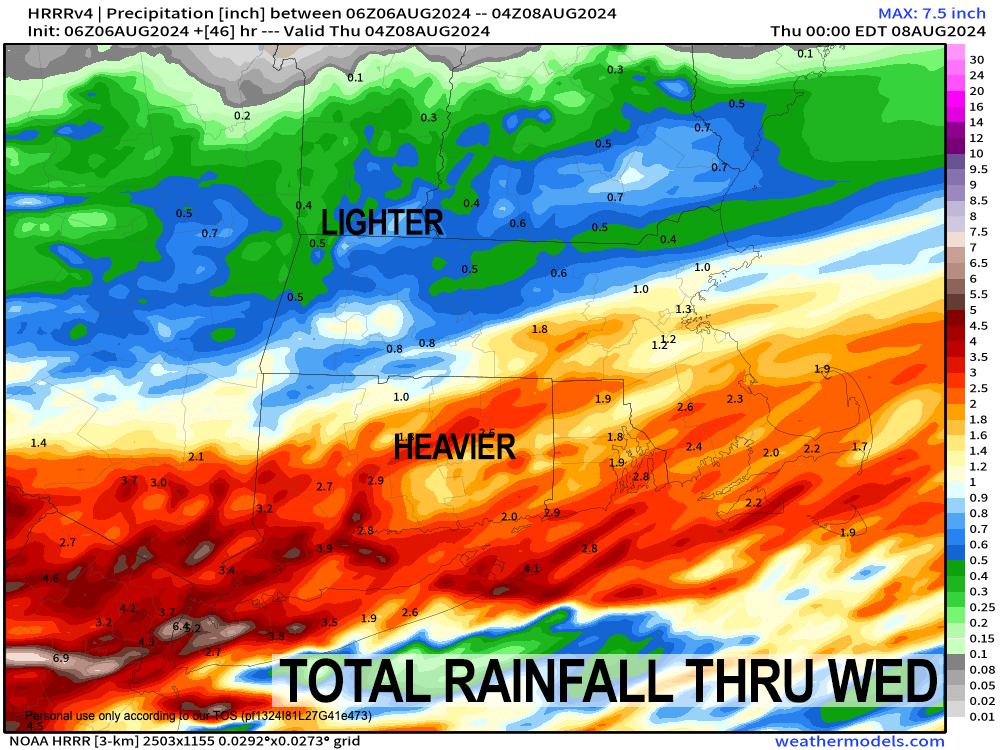
A wave of low pressure will ripple east along that front, and push steadier rainfall into southernmost New England, with heavier rains south of the Pike, and lighter to more moderate rains north of it overnight and into early Wednesday morning. Lows dip into the mid to upper 50s tonight.
After morning showers, Wednesday should benefit from an incoming ridge of higher pressures, which will dry things out and allow lower dewpoint / humidity air to advect into our region.
Highs will only reach the upper 60s to mid 70s (which were recently our low temperatures!!), and morning clouds should give way to partly sunny skies later in the afternoon as humidity decreases, with lows in the mid 50s under partly cloudy skies.
Thursday is the pick of the week for sure, with mostly sunny skies, high pressure, light wind, and highs in the mid to upper 70s! You couldn’t ask for a nicer day!
Clouds will then build at night as the remnants of Hurricane Debby wind up the Appalachian Mountains into the lower Mid-Atlantic region.
A few showers will be possible late Thursday night with lows in the 50s.
It is the Friday into Saturday timeframe where Debby will continue to undergo an extratropical system, losing its warm core and “opening up” as a cyclone and with a high humidity surge coming north into New England, we should see clusters of showers breaking out across the greater WMass region sometime on Friday.
Rain will become heavy at times into the night and through Saturday as Debby’s low center passes somewhere through CT or RI, putting us on the northwest side of the storm, which is where the heaviest rain tends to fall in tropical systems.
This means we could see Flood Watches hoisted in the coming days, with potential for flooding of streets and streams/rivers by Friday night into Saturday.
Humidity will also surge into the region Friday and Saturday with dewpoints into the 70s as air born from the tropics invades the region (or re-invades, I should say).
Highs will be in the 70s Thursday through Saturday, and after lows in the 50s Thursday night, they will hang in the 60s Friday and Saturday night with very humid air in place.
The Cape and Islands will have to watch for a burst of wind Saturday afternoon and night with gusts over 50mph possible as the storm center whips through southern New England, but the greater WMass region should only see gusts up to 20-30mph out of the south at times.
By Sunday, the storm pulls away, and after some morning showers, we should see partly sunny skies develop Sunday and Monday behind Debby’s departure, with highs in the 70s, lows in the 50s, and drier air working into the region.
For now, I see a much drier period behind Debby, as the Bermuda high is squashed well south and east away from the east coast of the U.S., giving New England a huge break from heat and humidity.
Have a great day!
“Follow your bliss and the universe will open doors for you where there were only walls.”
― Joseph Campbell
