
[7:55AM SUN: 8/4/24] ISOLATED TO SCATTERED STRONG TO SEVERE THUNDERSTORMS POSSIBLE TODAY AND TOMORROW, AND CAN’T RULE OUT A MICROBURST… VERY WARM AND HUMID THROUGH MONDAY FOLLOWED BY A COLD FRONTAL PASSAGE TO OUR SOUTH… FRONT HANGS CLOSE BY, BUT COOLS US DOWN TUESDAY THROUGH THE WEEKEND WITH 70S HIGHS… SCATTERED SHOWERS POSSIBLE AT TIMES NEXT WEEK… HURRICANE DEBBY RAINY REMNANTS MAY ARRIVE FRIDAY NIGHT INTO SATURDAY NIGHT… DEEPER DRIER AIR IS PULLED EASTWARD INTO NEW ENGLAND AS DEBBIE TRACKS SEAWARD ON SUNDAY INTO EARLY NEXT WEEK…
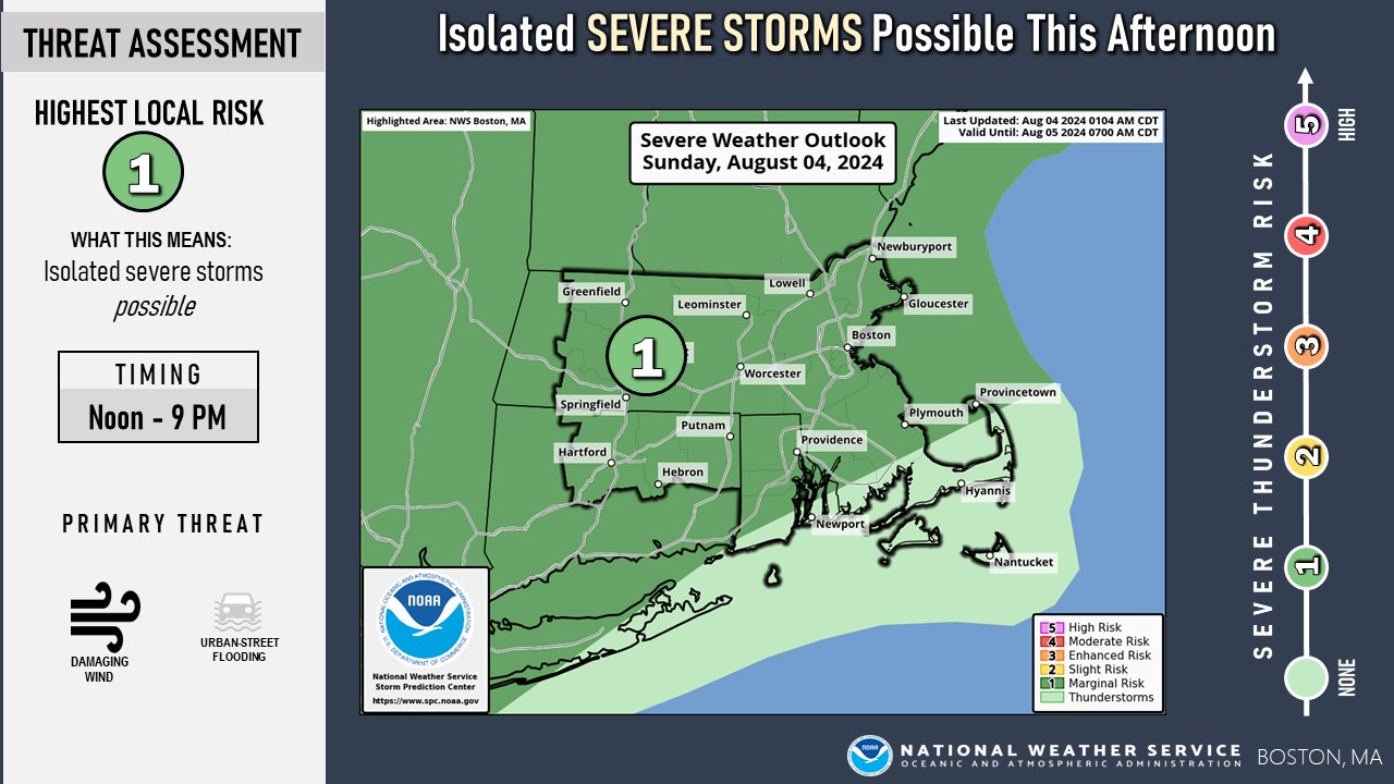
TABLE OF CONTENTS
* Daily Celestials (Sun/Moon Data)
* Sponsor Section
* Morning Discussion
* TIP: Scroll to your section, or read all
~~~~~~~~~~~~~~~~~~~~~~
YOUR DAILY CELESTIALS
~~~~~~~~~~~~~~~~~~~~~~
STAR:
–OUR STAR ROSE AT: 5:47am this morning
–OUR STAR WILL SET AT: 8:04pm this evening
–TOTAL DAYLIGHT TIME: 14 hours and 17 minutes
MOON:
–OUR MOON WILL SET AT: 8:36pm tonight
–MOON SET DIRECTION: West-Northwest
–OUR MOON WILL RISE AT: 6:43am this afternoon
–MOON RISE DIRECTION: East-Northeast
–MOON PHASE: Waxing Crescent (0.1%)
~~~~~~~~~~~~~~~~~~~~~~
>>> A NOTE FROM OUR WEEKEND SPONSOR <<<
Dave Hayes The Weather Nut is Sponsored by Individual Community Members, Patrons, and Gerard, Ghazey & Bates, P.C. GGBPC is a Northampton-based law firm regarded as the voice of pragmatic and well-reasoned estate planning, elder law and tax guidance in Western Massachusetts. The firm specializes in estate planning law, and expertly handles other matters such as Elder Law, Tax Law, as well as Real Estate purchase, sales, and refinance transactions. Contact GGBPC today to see how they can help!
~~~~~~~~~~~~~~~~~~~~~~
YOUR MORNING DISCUSSION
~~~~~~~~~~~~~~~~~~~~~~
Good morning peoples of the Golden West, I wish for you all manner of goodnesses, wonderments, delights, treats, and epiphanies of positivity on this muggy Sunday morning.
We’ve got patchy fog and temps in the 70s already, but fog will burn off as temps rise up into the low to mid 80s for highs today with dewpoints in the upper 60s to mid 70s, so very humid agani.
We’ll see more clouds than yesterday, but some partly sunny breaks are expected.
We also will see isolated showers or a thunderstorm at any point this morning into the mid afternoon, and a thunderstorm is already approaching Arlington and Shaftsbury, VT in western Bennington County.
As we get into the afternoon, another shortwave is going to track east towards our region, and will help spark areas of showers, downpours, and thunderstorms by mid to late afternoon, some of which could become strong to severe with strong gusty winds and street flooding. In addition, a microburst cannot be ruled out.
Because the temperature gradient higher up in the sky will be weak, any storms should die out after the sun sets and the surface cools.
Lows tonight will hang in the 60s with patchy fog expected as we dry up any showers.
For Monday, we have one more very warm and humid day before our pattern changes with an incoming cold front and surge of cooler air from Canada.
Highs will reach the mid to upper 80s and it will be very humid ahead of the front, which may be delayed to our north.
I still expect wind shear to be stronger, and with more sunshine and warmer surface temps, low level lapse rates should be steeper than today, so north of the Pike, and especially north of the Rt. 2 corridor, we have a decent chance that some of us could see strong to severe thunderstorms.
Sometime Monday night that front will come south and through the greater WMass region, headed for the south coast.
This will set up a zonal flow (i.e. more west to east) as we reside on the cool side of the front, but said front may stall somewhere either side of the south coast.
This brings great uncertainty in terms of waves of energy that may ripple west to east along it through the week and brinig shower chances to us, especially south of the Pike.
We’ll also be near the battle zone of cooler/drier air to our north and warmer/moister air to our south, so showers could form from that aspect alone.
Regardless, temps are coming DOWN, with highs expected in the 70s Tuesday through Friday, and lows in the 50s, with various sky covers and potential showery periods, so stay tuned for updates as things become more clear as time moves on. Humidity will come down too!
By the time we get to Friday afternoon into Saturday night, we watch the remnants of Debby which will likely have DUMPED rain onto South Carolina where historic flooding is possible.
Much of its wind component will be blown out of it, but it could help to focus rainfall in parts of our region by Friday night into Saturday as it passes south of New England, pulling east and speeding away by Sunday.
This is when the REAL dry air can finally get in here, with more sunshine and pleasant summer temps either side of 80º.
Have a great day, and I will update later on any activity that forms!
HAIKU OF THE DAY:
Yes, sweet 70s
Impatient am I, for you
Hey hot, humid! BYE.
“Follow your bliss and the universe will open doors for you where there were only walls.”
― Joseph Campbell