
[7:47AM SUN: 9/8/24] CHILLY START THIS MORNING, SUNSHINE ABOUNDS, GUSTY BY AFTERNOON UP TO 25MPH, COOLER AND AUTUMNAL… A SPOT SHOWER IS POSSIBLE LATE TODAY, AND AGAIN LATE TOMORROW… OTHERWISE, AN UPPER RIDGE AND SURFACE HIGH PRESSURE CENTER TRACKS EAST THROUGH THE WEEK, PRODUCING INCREASINGLY WARM TEMPERATURES INTO THE WEEKEND WITH MOSTLY SUNNY SKIES THE WHOLE WAY… NO BIG STORMS IN SIGHT…
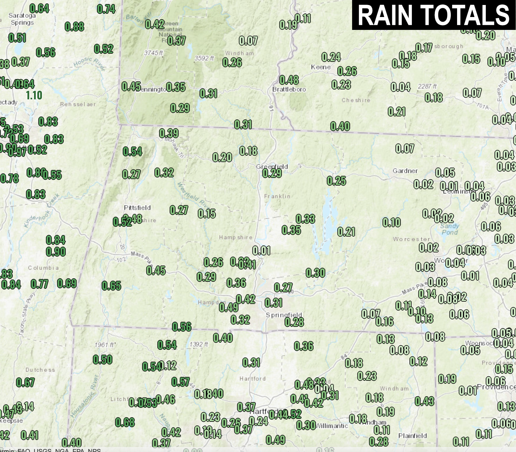
TABLE OF CONTENTS
* Daily Celestials (Sun/Moon Data)
* Sponsor Section
* Morning Discussion
* TIP: Scroll to your section, or read all
~~~~~~~~~~~~~~~~~~~~~~
YOUR DAILY CELESTIALS
~~~~~~~~~~~~~~~~~~~~~~
STAR:
–OUR STAR ROSE AT: 6:23am this morning
–OUR STAR WILL SET AT: 7:11pm this evening
–TOTAL DAYLIGHT TIME: 12 hours and 48 minutes
MOON:
–OUR MOON WILL RISE AT: 11:50am this morning
–MOON RISE DIRECTION: East-Southeast
–OUR MOON WILL SET AT: 9:24pm this evening
–MOON SET DIRECTION: West-Southwest
–MOON PHASE: Waxing Crescent (24.1%)
~~~~~~~~~~~~~~~~~~~~~~
>>> A NOTE FROM OUR WEEKEND SPONSOR <<<
Dave Hayes The Weather Nut is Sponsored by Individual Community Members, Patrons, and Gerard, Ghazey & Bates, P.C. GGBPC is a Northampton-based law firm regarded as the voice of pragmatic and well-reasoned estate planning, elder law and tax guidance in Western Massachusetts. The firm specializes in estate planning law, and expertly handles other matters such as Elder Law, Tax Law, as well as Real Estate purchase, sales, and refinance transactions. Contact GGBPC today to see how they can help!
~~~~~~~~~~~~~~~~~~~~~~
YOUR MORNING DISCUSSION
~~~~~~~~~~~~~~~~~~~~~~
Good morning everybody, our cold front has left the building and we’re left with damp ground, and a light shower or two over the northern Berkshires and southwest VT this morning.
Otherwise, sunshine sprays the day with a few fair weather clouds by afternoon and a high terrain spot shower possible late.
Highs will only be in the 60s, and with a mild pressure gradient remaining, west winds will gust 15-25mph today, perhaps up to 30mph in the high terrain.
Lows tonight will dip into the mid to upper 40s under mostly clear skies.
Monday and Tuesday will feature high pressure approaching from the west, and highs should rise into the low to mid 70s under mostly sunny skies. A weak disturbance rotates around the departing upper low which may bring a few spot showers late Monday or Monday night to the high terrain west of the CT River. Lows will drop to either side of 50º.
By Wednesday, high pressure moves overhead, and we warm into the upper 70s to low 80s for highs with lows in the 50s under sunny/clear skies.
By Thursday through Saturday, the upper ridge will be positioned across the eastern seaboard, and surface high will be southeast of us, which will promote southwesterly, warming flow into New England.
This will push highs well into the 80s for the late period into the weekend, so summah lovahs will get a reminder of the passing warm season.
Lows will continue to drop into the 50s, and dewpoint temps should hover in the 50s to low 60s through the week, so humidity is expected to be tolerable within this upcoming warm stretch.
Have a great rest of your weekend, and thanks for the reports yesterday!
HAIKU OF THE DAY:
Scattered blue rays spray
Oceans reflect blue skyward
Earth says “Hi” to Space
“Follow your bliss and the universe will open doors for you where there were only walls.”
― Joseph Campbell