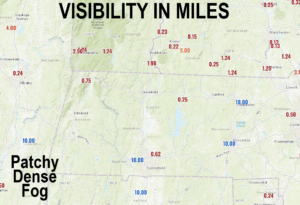
Good morning folks, we have some patchy dense fog in a number of spots this morning, so take it slow when casting your trillions of human cells (a/k/a your body) forward into these misty midsts.
This fog, where it forms, will lift with time, and reveal a beautiful, mostly sunny day. This fair weather should persist through the weekend prior to an upper trough pushing into the Great Lakes and bringing the chance for more showers and downpours by Tuesday and Wednesday, but before we dive into all of the weather details below, let’s check a note from our local and delicious sponsor, #TandemBagelCo, with their newest location in West Springfield, MA.
——————–
A NOTE FROM OUR SPONSOR:
DHTWN Is Sponsored by Members, Patrons & Tandem Bagel Company: No matter the weather, Tandem Bagel is always there for you at several valley locations to make your mornings brighter! With bagels baked fresh daily, house-whipped cream cheese, coffee, and tons of lunch options, Tandem is the perfect quick stop for lunch, breakfast, or a coffee and bagel to go. Find them in Easthampton, Northampton, Hadley, Florence, and West Springfield, or use their super-streamlined online ordering tool by visiting their website: https://www.tandembagelco.com
——————————————-
***DHTWN DAILY WEATHER REPORT***
——————————————-
NWS ALERTS
–Dense Fog Advisories are up for the central and northern Taconics of eastern NY, with patchy dense fog noted in other parts of the greater WMass region
DHTWN REMINDER
–The odds of being a human is 1 in 400 trillion… make it count, even in a small way (see Kurt Vonnegut quote at end of post)
DAILY CELESTIAL (STAR):
–OUR STAR ROSE AT: 6:23am this morning
–OUR STAR WILL SET AT: 7:12pm this evening
–TOTAL DAYLIGHT TIME: 12 hours and 49 minutes
DAILY CELESTIAL (MOON):
–OUR MOON WILL RISE AT: 6:46pm this evening
–OUR MOON WILL SET AT: 5:05am tomorrow morning
–MOON RISE DIRECTION: East-Southeast
–MOON SET DIRECTION: West-Southwest
–MOON PHASE: Waxing Gibbous 94.5%
———————-
DAILY TERRESTRIAL (ZoneCast)
ZONE 1 (Northern Region)
Southern VT, Southwest NH, N. Taconics NY
–High Temps: Mid to Upper 70s
–Low Temps: Low to Mid 50s
–Humidity: Comfortable
–Wind: Light northeast wind
–Skies: Mostly Sunny
–Precipitation: None
ZONE 2 (Central Region)
WMass, N. CMass, N. Litchfield County, C./S. Taconics NY
–High Temps: Mid to Upper 70s
–Low Temps: Low to Mid 50s
–Humidity: Comfortable
–Wind: Light northeast wind
–Skies: Mostly Sunny
–Precipitation: None
ZONE 3 (Southern Region)
S. CMass, S. Litchfield County, NC.CT, & NE.CT
–High Temps: Mid to Upper 70s
–Low Temps: Low to Mid 50s
–Humidity: Comfortable
–Wind: Light northeast wind
–Skies: Mostly Sunny
–Precipitation: None
———————-
WEATHER REPORT
Good morning everybody, there’s not too much to talk about this morning regarding our weather as it can be broken down into two main chunks: Chunk1 constitutes a fair weather stretch from today through Monday, and Chunk2 is comprised of an expected wet weather period late Monday and into Tuesday and Wednesday.
For today, we have huge high pressure building in from the west with time. Flow and light wind will still be onshore out of the northeast, and highs will reach the mid to upper 70s with a few spots hitting 80º.
Lows tonight will drop into the low to mid 50s with calm wind and clear sky.
For Friday, another mostly sunny day arrives as high pressure moves into the region, with highs in the upper 70s to low 80s and lows in the mid 50s under clear skies.
Saturday will see the high pressure system passing into and through the region by Sunday.
Saturday looks like the warmest of the two weekend days with highs in the low to mid 80s and lows in the upper 50s. Expect light wind, and tranquil conditions. Sunday sits down a touch, more into the upper 70s to low 80s for highs with lows either side of 60º.
By Monday, we likely experience one last fair weather day with mostly sunny skies (especially first half of the day) with highs in the mid to upper 70s, and lows in the low 60s as clouds build overnight.
By Tuesday and Wednesday, an upper level trough will spin into the Great Lakes, and pull more humid air from the south and cast it into the New England region.
This will generate a period of at least scattered showers on Tuesday into Wednesday, but the more clear impacts and rain amounts are murky at this time, so check back with me for more details as we get closer.
But hey, at least for now some more rain is on the way.
As Fat Albert said, hey, Hey, HEY! Have a great day!
Did you know that you can also follow me on Twitter?
AND REMEMBER…
“Hello babies. Welcome to Earth. It’s hot in the summer and cold in the winter. It’s round and wet and crowded. On the outside, babies, you’ve got a hundred years here. There’s only one rule that I know of, babies: Goddamn it, you’ve got to be kind.”
–Kurt Vonnegut
