
TABLE OF CONTENTS
* Daily Celestials (Sun/Moon Data)
* Sponsor Section
* Morning Discussion
* TIP: Scroll to your section, or read all
~~~~~~~~~~~~~~~~~~~~~~
YOUR DAILY CELESTIALS
~~~~~~~~~~~~~~~~~~~~~~
STAR:
–OUR STAR ROSE AT: 6:22am this morning
–OUR STAR WILL SET AT: 7:12pm this evening
–TOTAL DAYLIGHT TIME: 12 hours and 50 minutes
MOON:
–OUR MOON WILL RISE AT: 10:45am this morning
–MOON RISE DIRECTION: East-Southeast
–OUR MOON WILL SET AT: 8:58pm this evening
–MOON SET DIRECTION: West-Southwest
–MOON PHASE: Waxing Crescent (16.5%)
~~~~~~~~~~~~~~~~~~~~~~
>>> A NOTE FROM OUR WEEKEND SPONSOR <<<
Dave Hayes The Weather Nut is Sponsored by Individual Community Members, Patrons, and Gerard, Ghazey & Bates, P.C. GGBPC is a Northampton-based law firm regarded as the voice of pragmatic and well-reasoned estate planning, elder law and tax guidance in Western Massachusetts. The firm specializes in estate planning law, and expertly handles other matters such as Elder Law, Tax Law, as well as Real Estate purchase, sales, and refinance transactions. Contact GGBPC today to see how they can help!
~~~~~~~~~~~~~~~~~~~~~~
YOUR MORNING DISCUSSION
~~~~~~~~~~~~~~~~~~~~~~
Good morning everybody, we’re starting off with way less in terms of patchy fog compared to my expectations yesterday as dewpoints did not rise as quickly as I thought they would, so visibilities are largely in good shape.
We have some partial sunshine to start this morning, but clouds will thicken as we move into and through the afternoon.
Highs will rise into the low to mid 70s, and dewpoints will continue to rise into the 60s as a cold front takes aim at the greater WMass region for late this afternoon and through the evening.
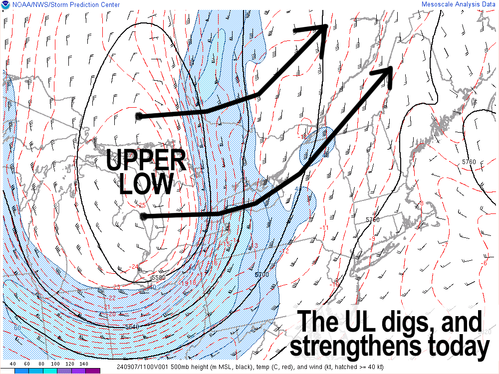
We have an upper low pressure system over the central Great Lakes region, and a surface low near the eastern tip of Lake Ontario, and the upper low will strengthen a bit, track east, then northeast into Quebec Province overnight.
This will feature will send a surface cold front into southwest New England and while we could see a few scattered showers in the 3-6pm timeframe, I think the 5-9pm time span is when we will see more numerous showers, and I can’t rule out a brief downpour or two, or an isolated thunderstorm or two, especially along and south of the Pike.
This activity swings through, and by midnight it should be out of here, with rapid onset of drier and cooler air sweeping in behind the front, such that lows will plummet into the mid to upper 40s with westerly breezes developing by Sunday morning.
In terms of rainfall amounts, a quarter inch to half inch should do it for most of us. Some will see less, with perhaps northwest CT into the southernmost Berkshires seeing more than half an inch. Regardless, no washouts are expected.
Sunday looks gorgeous and is definitely the pick of the weekend with highs only in the 60s with westerly gusts of 15-25mph with much drier air compared to today as dewpoints crash.
Lows will again dive into the mid 40s Sunday night with more sunshine expected for Monday with highs in the upper 60s to mid 70s, and lows in the low 50s under clear skies.
By Tuesday through late week, summah lovahs get another shot with more fun in the warm sun, as high pressure track east into and then east of New England mid to late week.
This will produce an entire week of mostly sunny skies with partly cloudy to mostly clear nights, and increasingly warm high temps into this coming Friday.
Highs Tuesday should reach the 75-80º range, but beyond that it looks like highs will climb into the upper 70s to mid 80s throughout the rest of the week. In fact, we could even see some upper 80s by late week!
However, lows should still be dropping into the 50s at night, and that’s because a lower humidity regime is expected with dewpoints in the 50s during the days, so a lovely week lies ahead.
Have a great day!
HAIKU OF THE DAY:
Another cool swipe
Another summer surge soon
Seesaw weather rolls
“Follow your bliss and the universe will open doors for you where there were only walls.”
― Joseph Campbell