TABLE OF CONTENTS
* Daily Celestials (Sun/Moon Data)
* Sponsor Note
* DHTWN Announcements
* Morning Discussion
* TIP: Scroll below for sections, or read all
~~~~~~~~~~~~~~~~~~~~~~
YOUR DAILY CELESTIALS
~~~~~~~~~~~~~~~~~~~~~~
STAR:
–OUR STAR ROSE AT: 6:46am this morning
–OUR STAR WILL SET AT: 6:32pm this evening
–TOTAL DAYLIGHT TIME: 11 hours and 46 minutes
MOON:
–OUR MOON WILL SET AT: 5:50pm this afternoon
–MOON SET DIRECTION: West
–OUR MOON WILL RISE AT: 5:34am tomorrow morning
–MOON RISE DIRECTION: East
–MOON PHASE: Waning Crescent (4.8%)
~~~~~~~~~~~~~~~~~~~~~~
A NOTE FROM OUR SPONSOR
~~~~~~~~~~~~~~~~~~~~~~
Dave Hayes The Weather Nut is Sponsored by Individual Community Members, Patrons, and Tandem Bagel Company… No matter the weather, Tandem Bagel is always there for you at several valley locations to make your mornings brighter! With *New Pizza Bagels(!)*, along with bagels baked fresh daily (including Gluten-Free options), house-whipped cream cheese, coffee, and tons of lunch options, Tandem is the perfect quick stop for lunch, breakfast, or a coffee and bagel to go.
You can either 1) visit them in Easthampton, Northampton, Hadley, Florence, and/or West Springfield, 2) hire them to cater your next event, or 3) use their super-streamlined online ordering tool by visiting their website and clicking the “Catering” or “Order Online” links at https://www.tandembagelco.com
~~~~~~~~~~~~~~~~~~~~~~
DHTWN ANNOUNCEMENTS
~~~~~~~~~~~~~~~~~~~~~~
~ Look for Dave’s New Mobile Weather App
(Late 2024 Release)
https://westernmassweather.com/dhtwn-mobile-app/
~ Subscribe to Dave’s Weekly Newsletter
(Get the free 70-page ebook: Top 15 WMass Storms!)
https://westernmassweather.com/homepage/dhtwn-nutletter-signup/
~~~~~~~~~~~~~~~~~~~~~~
YOUR MORNING DISCUSSION
~~~~~~~~~~~~~~~~~~~~~~
Good morning everybody, we’ve got some dense fog out there as air temps and dewpoints have settled to around either side of 50º, so take it easy early on when you head out the door.
We will be dominated by high pressure and upper ridging this week, which will keep us mostly dry.
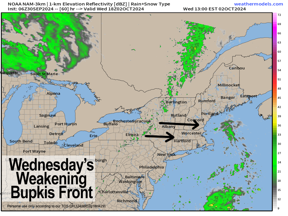
While we could see a few showers late Tuesday night into Wednesday, it would likely only be in the Berkshires and southwest VT, if that, as our front will weaken as it pushes the torn apart cloud remnants of Helene and sends it whimpering out to sea after completely devastating western North Carolina and other nearby parts of that region.
The quick sky pattern is partly sunny overall today and tomorrow, mostly cloudy Wednesday, and then mostly sunny Thursday and Friday.
Highs today reach the upper 60s to mid 70s, and tomorrow more like mid 60s to low 70s, with lows dropping to either side of 50º both nights (again, with some more patchy fog tonight, but not as widespread at this morning).
We cloud up Tuesday night, and see cold frontal clouds move through Wednesday with a few spot showers possible. Highs will only reach the mid to upper 60s with lows near 50º.
We then warm up late week with highs well into the 70s as sunshine increases due to high pressure.
A weak cold front runs through the region Friday night into Saturday with a few showers possible, and cooler highs in the 60s over the weekend with lows in the 40s. Sunday will definitely be the weekend pick!
By early next week we’ll be seeing temps come up once again, but the upper levels look to be shifting and developing a large, cool trough in the northeast U.S., and if that happens, not only could we see some legit October storminess along the New England southern coastline, but a stepdown to cooler temps (as in highs in the 50s to low/mid 60s) may be in the cards.
It’s something to monitor, which I will do with vim AND vigor, but for now, enjoy the calm weather and seasonably mild/warm temps.
Have a great day!
“Follow your bliss and the universe will open doors for you where there were only walls.”
― Joseph Campbell
