>>> YOUR DAILY CELESTIALS <<<
STAR:
–OUR STAR ROSE AT: 6:46am this morning
–OUR STAR WILL SET AT: 6:43pm this evening
–TOTAL DAYLIGHT TIME: 11 hours and 47 minutes
MOON:
–OUR MOON WILL RISE AT: 7:18pm this afternoon
–MOON RISE DIRECTION: East-Northeast
–OUR MOON WILL SET AT: 9:23am tomorrow morning
–MOON SET DIRECTION: West-Northwest
–MOON PHASE: Waning Gibbous (98.4%)
~~~~~~~~~~~~~~~~~~~~~~
>>> DAVE’S WEEKLY WEATHER NUTSHELL <<<
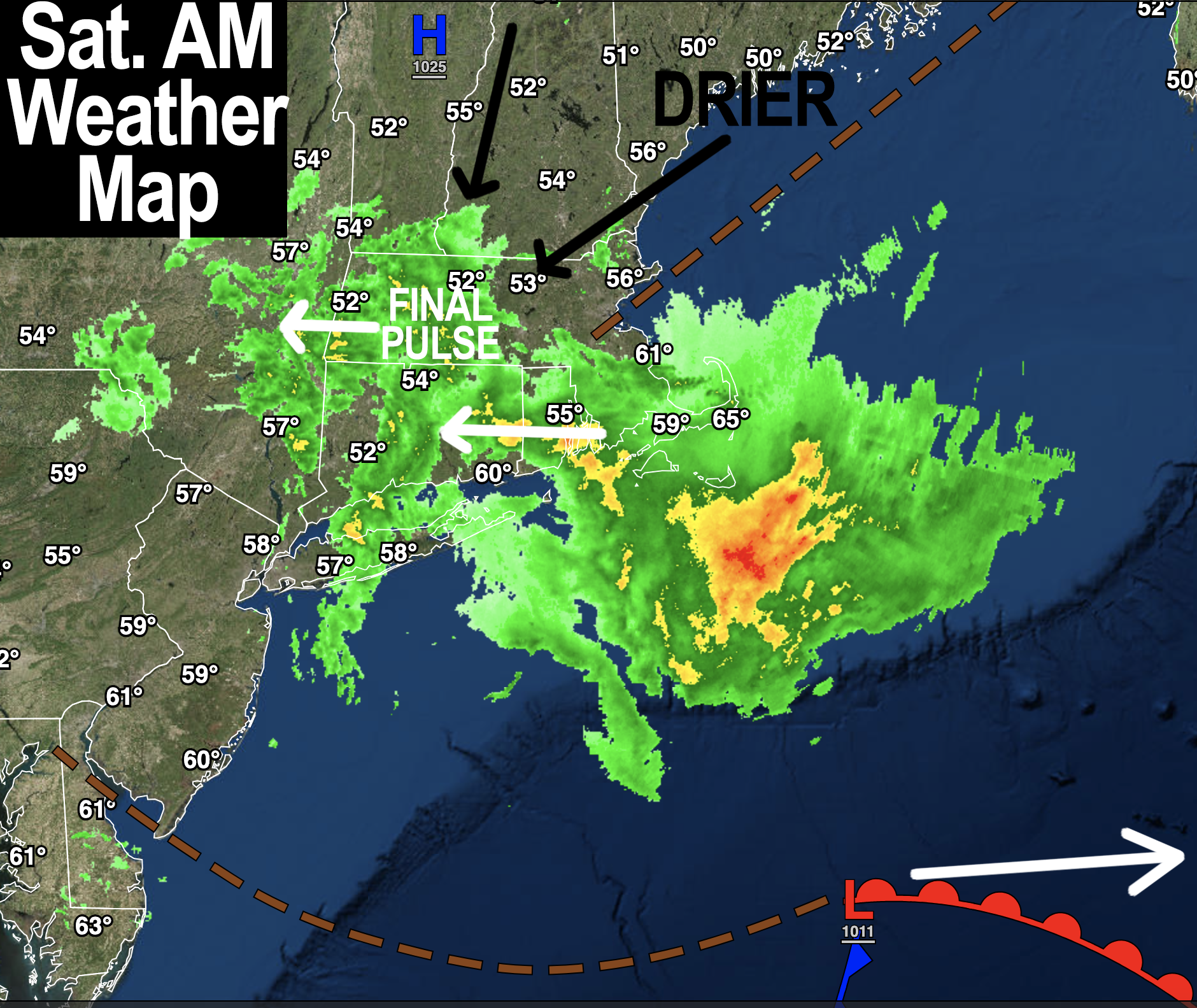
–Final pulse of rain is moving westward through WMass at 7am, and drying in CMass and points northeast
–This will continue, so most of the rain should quit by mid to late morning with a few showers or drizzle patches possible into early afternoon
–Then we continue to dry with time, with a few sunny breaks possible north and northeast by late afternoon
–Highs low to mid 60s, lows upper 40s to low 50s with continued drying and clearing
–Sunday is the pick of the weekend by a mile, with patchy fog early followed by mostly sunny skies, highs upper 60s to mid 70s, lows near 50º… similar set up for Monday and Monday night
–Tuesday through Thursday see high pressure move overhead, and then east off of our coastline
–More fair weather expected with sunshine and highs well into the 70s, with some low 80s possible by mid week in the Pioneer Valley!
–Lows will be in the 50s through this Tues-Thurs period
–We likely cloud up Friday with the first in a pair of cold fronts that will bring showers/storms to the region Friday afternoon/night
–A second, sharper cold front may move through again and deliver a cold shot and our 1st frost(!!), but before we get into the details let’s check a note from our local weekend sponsor, #GerardGhazeyBatesPC, an estate planning law firm in Northampton, MA.
~~~~~~~~~~~~~~~~~~~~~~
>>> A NOTE FROM OUR SPONSOR <<<
Dave Hayes The Weather Nut is Sponsored by Individual Community Members, Patrons & Gerard, Ghazey & Bates, P.C. GGBPC is a Northampton-based law firm regarded as the voice of pragmatic and well-reasoned estate planning, elder law and tax guidance in Western Massachusetts. The firm specializes in estate planning law, and expertly handles other matters such as Elder Law, Tax Law, as well as Real Estate purchase, sales, and refinance transactions. Contact GGBPC today to see how they can help!
>>> MORNING DISCUSSION <<<
Good morning everybody, rainfall is moving east to west through the region and is about to clear the northern and central valley and linger a bit in the southern valley before we transition to just scattered showers and some drizzle/fog patches prior to drying out more this afternoon.
Overnight we picked up an additional quarter to half inch of rain, with some seeing less, and overall the 1-4″ rainifall totals I offered came to pass, except a few areas got over 4″ for sure, and areas of CMass and SWNH where I thought less would fall saw 0.75-2″, roughly.
For this morning, rain continues to weaken over the area, with some lingering lighter showers or drizzle patches.
The storm is pulling east, and so the better dynamics are leaving with it, so this is the last hurrah this morning.
We will continue to dry this afternoon, but it should remain mostly cloudy with highs in the low to mid 60s. Some sunny breaks are possible late, especially the further north and northeast you go north of Rt. 2.
Lows tonight as we continue to clear and dry will drop down into the upper 40s to low 50s.
High pressure builds in on Sunday, which is by far the pick of the weekend with highs in the mid 60s to mid 70s, and lows near 50º (Monday will likely be a copy of Sunday, as well).
By Tuesday through Thursday, high pressure will build more firmly overhead and sit on us like a mother hen (but won’t call us George) and warm us right up! Highs will reach the 70s to low 80s during this period for a nice fleeting taste of summah, which will not last.
That’s because we have a pair of storm systems that will be swinging frontal boundaries through our region, the first of which comes through Friday afternoon/night, and the second of which likely comes through the following Monday after a decent weekend a week from now.
Next Friday afternoon into Saturday morning (as of now) looks like showers and thunderstorms will swing through as we cool temps down for that weekend, though fair weather is possible at this point.
By that following Monday, a stronger and sharper front may rip through, and deliver our first real cold shot of the incoming cold season.
In fact, it’s possible that by Tuesday morning we could see lows down to either side of the freezing mark, so for those watching for first frost, you have been warned to stay tuned for future updates.
Have a great day!
>>> BE KIND <<<
“Hello babies. Welcome to Earth. It’s hot in the summer and cold in the winter. It’s round and wet and crowded. On the outside, babies, you’ve got a hundred years here. There’s only one rule that I know of, babies: Goddamn it, you’ve got to be kind.”
–Kurt Vonnegut
