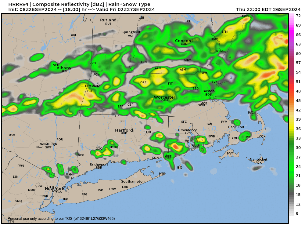
[7:10AM THUR 9/26/24] STEADIER SHOWERS THIS MORNING ARE MOSTLY ALONG AND NORTH OF THE RT. 2 CORRIDOR, WITH SCATTERED SHOWERS SOUTH OF THERE… THEN STEADIER/HEAVIER SHOWERS WILL DEVELOP THIS AFTERNOON AND EVENING, WITH TIME, INTO THE REST OF WMASS, CMASS, AND PARTS OF NORTHERN CT AS THE UPPER LOW AND FRONT SWINGS EAST… FAIR WEATHER FRIDAY THROUGH MONDAY, PLEASANTLY WARM… THEN MORE SHOWERS TUES/WED WITH HELENE’S PATIENT REMNANTS BEING SWEPT EAST BY ANOTHER FRONT…

TABLE OF CONTENTS
* Daily Celestials (Sun/Moon Data)
* Sponsor Note
* DHTWN Announcements
* Morning Discussion
* TIP: Scroll below for sections, or read all
~~~~~~~~~~~~~~~~~~~~~~
YOUR DAILY CELESTIALS
~~~~~~~~~~~~~~~~~~~~~~
STAR:
–OUR STAR ROSE AT: 6:42am this morning
–OUR STAR WILL SET AT: 6:439pm this evening
–TOTAL DAYLIGHT TIME: 11 hours and 57 minutes
MOON:
–OUR MOON WILL SET AT: 4:13pm this afternoon
–MOON SET DIRECTION: Northwest
–OUR MOON WILL RISE AT: 1:17am tomorrow morning
–MOON RISE DIRECTION: Northeast
–MOON PHASE: Waning Crescent (33.1%)
~~~~~~~~~~~~~~~~~~~~~~
A NOTE FROM OUR SPONSOR
~~~~~~~~~~~~~~~~~~~~~~
Dave Hayes The Weather Nut is Sponsored by Individual Community Members, Patrons, and Tandem Bagel Company… No matter the weather, Tandem Bagel is always there for you at several valley locations to make your mornings brighter! With *New Pizza Bagels(!)*, along with bagels baked fresh daily (including Gluten-Free options), house-whipped cream cheese, coffee, and tons of lunch options, Tandem is the perfect quick stop for lunch, breakfast, or a coffee and bagel to go.
You can either 1) visit them in Easthampton, Northampton, Hadley, Florence, and/or West Springfield, 2) hire them to cater your next event, or 3) use their super-streamlined online ordering tool by visiting their website and clicking the “Catering” or “Order Online” links.
~~~~~~~~~~~~~~~~~~~~~~
DHTWN ANNOUNCEMENTS
~~~~~~~~~~~~~~~~~~~~~~
~ Look for Dave’s New Mobile Weather App
(Late 2024 Release)
~ Subscribe to Dave’s Weekly Newsletter
(Get the free 70-page ebook: Top 15 WMass Storms!)
~~~~~~~~~~~~~~~~~~~~~~
YOUR MORNING DISCUSSION
~~~~~~~~~~~~~~~~~~~~~~
Good morning everybody, we’ve already had showers overnight and this morning moving through the region, and while south of the Rt. 2 corridor has only seen about a tenth of an inch or less, along and north of that region in the northern Berkshires, Franklin County and northern CMass up into SVT and SWNH, we’ve already seen a quarter to three-quarters of an inch of rainfall.
This is going to be par for the course with this system, with heavier rain totals up that way, and less so south of Rt. 2.
So, as our upper low sweeps east into northern NY and northern New England today, moisture from further down the Appalachian Chain will be drawn northeastward into New England with periods of showers continuing this morning mainly in northern areas, and then better filling in south of Rt. 2 in MA and CT this afternoon, and especially tonight with thunder and a few downpours possible.
No flooding concerns are expected, though I can’t rule out a couple of isolated street flooding issues if some guidance is correct and we see some training of heavier showers over the same areas this evening.
Highs will climb to the mid to upper 60s with lows in the 50s, with shower activity tapering by or after midnight.
Clouds may be slow to clear on Friday, so I am looking at more of a partly sunny day on average, with more clouds than sun in the morning, and then some clearing through the day with highs in the upper 60s to mid 70s, with lows in the low to mid 50s under partly cloudy skies.
The weekend through Monday looks pleasant right now, and dry, with highs in the low 70s and lows near 50º under partly sunny/cloudy skies.
By Tuesday into Wednesday, I’ll be watching a frontal boundary and upper level system traversing the Great Lakes region into the northeast from west to east, which will help pick up the blown-out remnants of Hurricane Helene from near the Mississippi River Valley and drag it east to pass through or just south of southern New England.
This will introduce our next chance of showers into the region through about mid week, with fair weather expected behind that system.
I hope you have a great day!
“Follow your bliss and the universe will open doors for you where there were only walls.”
― Joseph Campbell
