TABLE OF CONTENTS
* Daily Celestials (Sun/Moon Data)
* Sponsor Note
* DHTWN Announcements
* Morning Discussion
* TIP: Scroll below for sections, or read all
~~~~~~~~~~~~~~~~~~~~~~
YOUR DAILY CELESTIALS
~~~~~~~~~~~~~~~~~~~~~~
STAR:
–OUR STAR ROSE AT: 6:41am this morning
–OUR STAR WILL SET AT: 6:41pm this evening
–TOTAL DAYLIGHT TIME: 12 hours and 0 minutes
MOON:
–OUR MOON WILL SET AT: 3:33pm this afternoon
–MOON SET DIRECTION: Northwest
–OUR MOON WILL RISE AT: 12:10am tomorrow morning
–MOON RISE DIRECTION: Northeast
–MOON PHASE: Waning Crescent (43.1%)
~~~~~~~~~~~~~~~~~~~~~~
A NOTE FROM OUR SPONSOR
~~~~~~~~~~~~~~~~~~~~~~
Dave Hayes The Weather Nut is Sponsored by Individual Community Members, Patrons, and Tandem Bagel Company… No matter the weather, Tandem Bagel is always there for you at several valley locations to make your mornings brighter! With *New Pizza Bagels(!)*, along with bagels baked fresh daily (including Gluten-Free options), house-whipped cream cheese, coffee, and tons of lunch options, Tandem is the perfect quick stop for lunch, breakfast, or a coffee and bagel to go.
You can either 1) visit them in Easthampton, Northampton, Hadley, Florence, and/or West Springfield, 2) hire them to cater your next event, or 3) use their super-streamlined online ordering tool by visiting their website and clicking the “Catering” or “Order Online” links.
~~~~~~~~~~~~~~~~~~~~~~
DHTWN ANNOUNCEMENTS
~~~~~~~~~~~~~~~~~~~~~~
~ Look for Dave’s New Mobile Weather App
(Late 2024 Release)
~ Subscribe to Dave’s Weekly Newsletter
(Get the free 70-page ebook: Top 15 WMass Storms!)
~~~~~~~~~~~~~~~~~~~~~~
YOUR MORNING DISCUSSION
~~~~~~~~~~~~~~~~~~~~~~
Good morning everybody, we’ve got some Berkshires and western hilltown showers tracking northeast into SVT this early morning. After that batch moves through, we’ll get a lull in the action.
Still, mostly cloudy skies will remain with highs in the low to mid 60s and a light southeast wind as slow-to-depart high pressure leaves us with a final drying influence for today before moisture overwhelms our region late tonight and through Thursday evening.
Lows will drop into the low to mid 50s tonight and we’ll see some more scattered showers develop as the night wears on.
Thursday morning looks quite wet, and rain could fall heavily at times, so don the galoshes and old-timey umbrellas as it’ll be a wet day most likely tomorrow with highs in the mid to upper 60s.
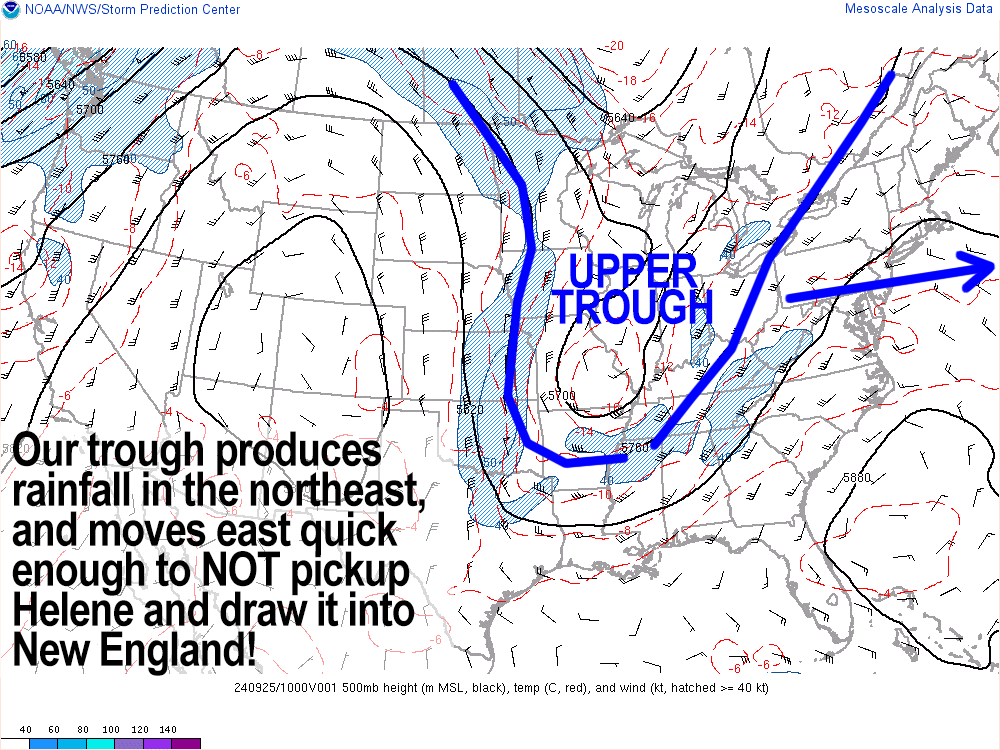
An upper level trough will be tracking east out of the Great Lakes toward New England, and will push a surface cold front along, which should produce some heavier rains in the afternoon as well, with thunder possible.
By tomorrow I hope to have timing better in terms of rain tapering and departure, but for now, expect rains to last into at least Thursday evening before tapering off. Lows will dip to the mid 50s.
Luckily for us in terms of avoiding the impacts of soon-to-be Hurricane Helene’s remnants, we have the trough tracking to the east fast enough so as to not direct Helene northeast and up its eastern flank into New England, AND we also have eastern Canadian high pressure dropping south into New England by Friday which will produce a double-whammy malachi crunch (DWMC), which will send Helene WESTWARD toward western Tennessee… works for me! We don’t need any more flooding issues.
Friday through Tuesday looks lovely, with a mix of partly to mostly sunny skies and highs in the low to mid 70s, lows in the low 50s, and light and variable winds – 5 consecutive days of gorgeousness!
Thereafter, we may see a pair of cold fronts with some showers Wednesday and again on Saturday, and these looks to drop our temps down into a deeper Fall feel, which is right on time as we pass into October next week.
I hope you have a great day!
“Follow your bliss and the universe will open doors for you where there were only walls.”
― Joseph Campbell
