Good morning everybody, there’s a lot to discuss about our severe weather potential today, but before we dive into all of the weather details below, let’s check a note from our local weekend sponsor, #YankeeMattressFactory, with their main headquarters in Agawam, MA along with stores located around the valley.
——————–
A NOTE FROM OUR WEEKEND SPONSOR:
DHTWN is sponsored by members, patrons, and Yankee Mattress Factory. Yankee Mattress is employee-owned, and mattresses are handmade locally in Agawam, MA. Several years ago I purchased a Yankee mattress and was very pleased with their quality and the buying experience, which was friendly and low pressure. Starting on September 1st and running through October 31st, Yankee Mattress will be partnering with the American Cancer Society to raise money to support breast cancer research and local services. A portion of each mattress sale will go towards their goal of donating $10,000 towards this cause. Visit the Yankee Mattress store closest to you in Agawam, Springfield, Northampton, or Greenfield, or click for more info.
——————————————-
***DHTWN DAILY WEATHER REPORT***
——————————————-
Top of the morning to you and yours!
While we have a low severe weather chance today, it exists, especially in northern CT and southernmost MA, so I’m going to take my most favorite character in the whole wide world, digital or otherwise, and bust a move with some double–dash proliferation activities, weather details incoming!
–To start, it’ll be mostly in the 60s today with clouds increasing, low 60s in the Berkshires and SVT/SWNH, upper 60s in the southern valley, and mid 60s in between
–The day starts off dry and ends with scattered showers, downpours, and thunderstorms, some of which may become strong to severe
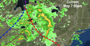
–To broaden our weather picture as to what the culprits and players are, we have a broad upper level circulation and trough over the Great Lakes
–This is sending a surface warm front northeast towards New England today, which will help produce scattered showers and storms
–One issue we have to monitor is that there will be low level helicity, or spin in the lower atmosphere
–With humidity increasing, especially in Connecticut, we have to watch for an isolated tornado or two
–In addition, this upper level feature is pushing stronger wind shear (i.e. change with the speed and/or direction of the wind from surface to sky)
–Finally, it will be much colder aloft, and with good rising air, we could see larger hail develop as updrafts in any storms could reach up to the freezing layer aloft
–So, at any point in the afternoon some scattered showers are possible, but the strong to severe storm potential exists mostly from mid afternoon into early evening, say 2 or 3pm to 7 or 8pm
–I will be monitoring this and in the saddle all day, so please check back with me for updates, even if you don’t see me in your feeds (your feed is not in my power)
–After that activity passes us to the east, a period of fairly pedestrian weather arrives until next weekend
–A cold front will move through overnight with a few more showers, and lows will drop to the low to mid 50s with patchy fog possible
–For Monday, we’ll continue southwesterly flow behind the cold front given the broad, more horizontal upper low still near the region
–Highs will reach the upper 60s to low 70s under partly sunny skies with a few afternoon instability showers scattered about
–Lows will dip into the upper 40s to low 50s
–Tuesday is looking quite nice with mostly sunny skies and a passing shower or two with a moisture-starved cold frontal passage
–Highs will reach the 65-70º range, and lows will drop into the mid 40s
–Wednesday through Saturday look lovely, just beautiful early Autumn days!
–Expect mostly sunny skies and highs in the 60s with lows in the 40s, and not much wind to speak of
–Thursday will be the chilliest of those 4, and instead of the 60s for highs, we should see more like mid 50s to low 60s for highs with lows in the mid to upper 30s
–By late Saturday night into Sunday we may be dealing with the tropical rainy remnants of Hurricane Ian, although a huge high pressure system responsible for Friday and Saturday’s fair weather will run interference and try to delay Ian’s arrival
–I don’t expect it to be anything more than a remnant low with some downpours possible
–After that? It’s looking like a major Canadian high pressure system to step us down into the next level of cool air, and if that happens, more widespread frosts are possible by about 10 days from now, so stay tuned for updates on that, too.
Check back with me this afternoon, and have a great day!
Remember that you can also follow me on Twitter.
AND REMEMBER…
“Hello babies. Welcome to Earth. It’s hot in the summer and cold in the winter. It’s round and wet and crowded. On the outside, babies, you’ve got a hundred years here. There’s only one rule that I know of, babies: Goddamn it, you’ve got to be kind.”
–Kurt Vonnegut
