TABLE OF CONTENTS
* Daily Celestials (Sun/Moon Data)
* Sponsor Note
* DHTWN Announcements
* Morning Discussion
* TIP: Scroll below for sections, or read all
~~~~~~~~~~~~~~~~~~~~~~
YOUR DAILY CELESTIALS
~~~~~~~~~~~~~~~~~~~~~~
STAR:
–OUR STAR ROSE AT: 6:40am this morning
–OUR STAR WILL SET AT: 6:43pm this evening
–TOTAL DAYLIGHT TIME: 12 hours and 3 minutes
MOON:
–OUR MOON WILL SET AT: 2:41pm this afternoon
–MOON SET DIRECTION: Northwest
–OUR MOON WILL RISE AT: 11:06pm this evening
–MOON RISE DIRECTION: Northeast
–MOON PHASE: Waning Gibbous (53.7%)
~~~~~~~~~~~~~~~~~~~~~~
A NOTE FROM OUR SPONSOR
~~~~~~~~~~~~~~~~~~~~~~
Dave Hayes The Weather Nut is Sponsored by Individual Community Members, Patrons, and Tandem Bagel Company… No matter the weather, Tandem Bagel is always there for you at several valley locations to make your mornings brighter! With *New Pizza Bagels(!)*, along with bagels baked fresh daily (including Gluten-Free options), house-whipped cream cheese, coffee, and tons of lunch options, Tandem is the perfect quick stop for lunch, breakfast, or a coffee and bagel to go.
You can either 1) visit them in Easthampton, Northampton, Hadley, Florence, and/or West Springfield, 2) hire them to cater your next event, or 3) use their super-streamlined online ordering tool by visiting their website and clicking the “Catering” or “Order Online” links.
~~~~~~~~~~~~~~~~~~~~~~
DHTWN ANNOUNCEMENTS
~~~~~~~~~~~~~~~~~~~~~~
~ Look for Dave’s New Mobile Weather App
(Late 2024 Release)
~ Subscribe to Dave’s Weekly Newsletter
(Get the free 70-page ebook: Top 15 WMass Storms!)
~~~~~~~~~~~~~~~~~~~~~~
YOUR MORNING DISCUSSION
~~~~~~~~~~~~~~~~~~~~~~
Good morning everybody, we’ve awoken to another day on Earth as we careen through the Cosmos, and I can tell you the news that you already know, which is that life keeps hurling challenges and problems to solve, and pain to feel, and an endless array of things that we must weather.
I wish for you strength, compassion, love, perspective, and courage to keep going as you face whatever you are facing today.
As for our external weather, we’re trending towards more of a partly sunny to then mostly cloudy day from west to east as an upper level low with a surface disturbance tracks east and east-northeast toward New England from the middle of the country and Great Lakes region.
As clouds increase later today, a few sprinkles or light showers are possible this afternoon with highs in the mid to upper 60s. Clouds increase tonight with lows in the upper 40s to low 50s.
While some showers are possible at any point tomorrow / Wednesday, we’ll have a better chance by afternoon into the evening of getting wet, and some showers may be heavier and I also can’t rule out a rumble of thunder.
Highs Wednesday reach the low to mid 60s, so dare I say it could be a touch raw from some in the northern Berkshires and western hilltowns?
It’s possible, and lows will settle down into the low to mid 50s as showers increase Wednesday night into Thursday morning, tapering of rain by Thursday mid afternoon as a cold front sweep east through the region.
By later Thursday and Thursday night the upper level low has to swing overhead, and that could spark a few lighter showers, but drier air moving in at the surface should hopefully take some potency out of any that do form.
Highs Thursday will climb into the upper 60s to low 70s with lows in the 50s as skies begin to clear.
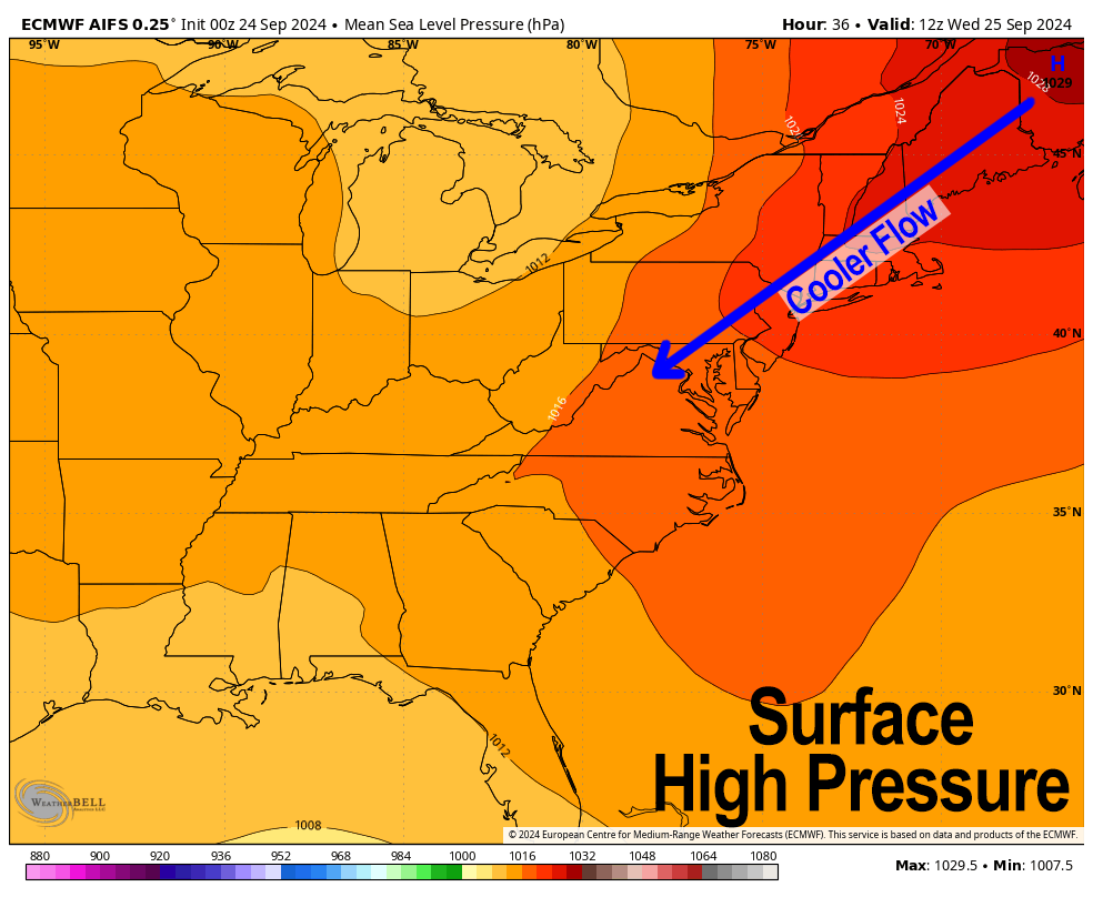
High pressure from Quebec then slides right back down and southward through New England behind our departing storm, and blasts through the core of Helene’s remnants, producing the ultimate You-Shall-Not-Pass-Gandalf-The-Grey moment, thereby preventing any tropical rains from wetting any New England grounds.
Sorry, I’m a Lord of the Rings nerd!
Instead, Friday through Monday looks a bit warmer, and much sunnier with highs in the upper 60s to mid 70s, and lows in the upper 40s to mid 50s, setting us up for a killer final weekend of September!
That’s your weather news, and I hope you have a great day!
“Follow your bliss and the universe will open doors for you where there were only walls.”
― Joseph Campbell
