>>> YOUR DAILY CELESTIALS <<<
STAR:
–OUR STAR ROSE AT: 6:38am this morning
–OUR STAR WILL SET AT: 6:46pm this evening
–TOTAL DAYLIGHT TIME: 12 hours and 8 minutes
MOON:
–OUR MOON WILL RISE AT: 3:36pm this afternoon
–MOON RISE DIRECTION: Southeast
–OUR MOON WILL SET AT: 12:10am tomorrow morning
–MOON SET DIRECTION: Southwest
–MOON PHASE: Waxing Gibbous (57.5%)
~~~~~~~~~~~~~~~~~~~~~~
>>> DAVE’S WEEKLY WEATHER NUTSHELL <<<
–The battle of dry air north and wet air south is underway this weekend
–Northern CT and extreme southern WMass/CMass will see wetter conditions this weekend, drier north of the Pike
–Light to perhaps moderate showers will enter northern CT by mid to late morning, then come up to the Pike or Route 9 MA level by mid day into early afternoon, and weaken tonight
–Areas along/north of Route 2 should stay mostly dry until later afternoon with scattered showers possible, but much lighter precip overall
–Drizzle possible tonight, then we will see some more showers tomorrow from Ophelia’s remnants (again heaviest south, lighter north)
–Some areas along and north of Rt. 2 may stay mostly dry this weekend, especially in SVT and SWNH
–BUST POTENTIAL: Many more of us could remain dry in WMass/CMass if high pressure to our north “wins out”
–Up to an inch or so of rain is expected along/south of the Pike as of now, with much less as you go further north where a sharp northern cutoff to rain shield may set up due to dry air
–Monday sees a few morning showers possible
–Thereafter, big drying moves into the regiion as a big high pressure center heads toward New England
–Get ready for a large Autumn taste this coming week as cooler temps, low humidity, and chilly mornings setups, but before we get into the details let’s check a note from our local weekend sponsor, #GerardGhazeyBatesPC, an estate planning law firm in Northampton, MA.
~~~~~~~~~~~~~~~~~~~~~~
>>> A NOTE FROM OUR SPONSOR <<<
Dave Hayes The Weather Nut is Sponsored by Individual Community Members, Patrons & Gerard, Ghazey & Bates, P.C. GGBPC is a Northampton-based law firm regarded as the voice of pragmatic and well-reasoned estate planning, elder law and tax guidance in Western Massachusetts. The firm specializes in estate planning law, and expertly handles other matters such as Elder Law, Tax Law, as well as Real Estate purchase, sales, and refinance transactions. Contact GGBPC today to see how they can help!
>>> MORNING DISCUSSION <<<
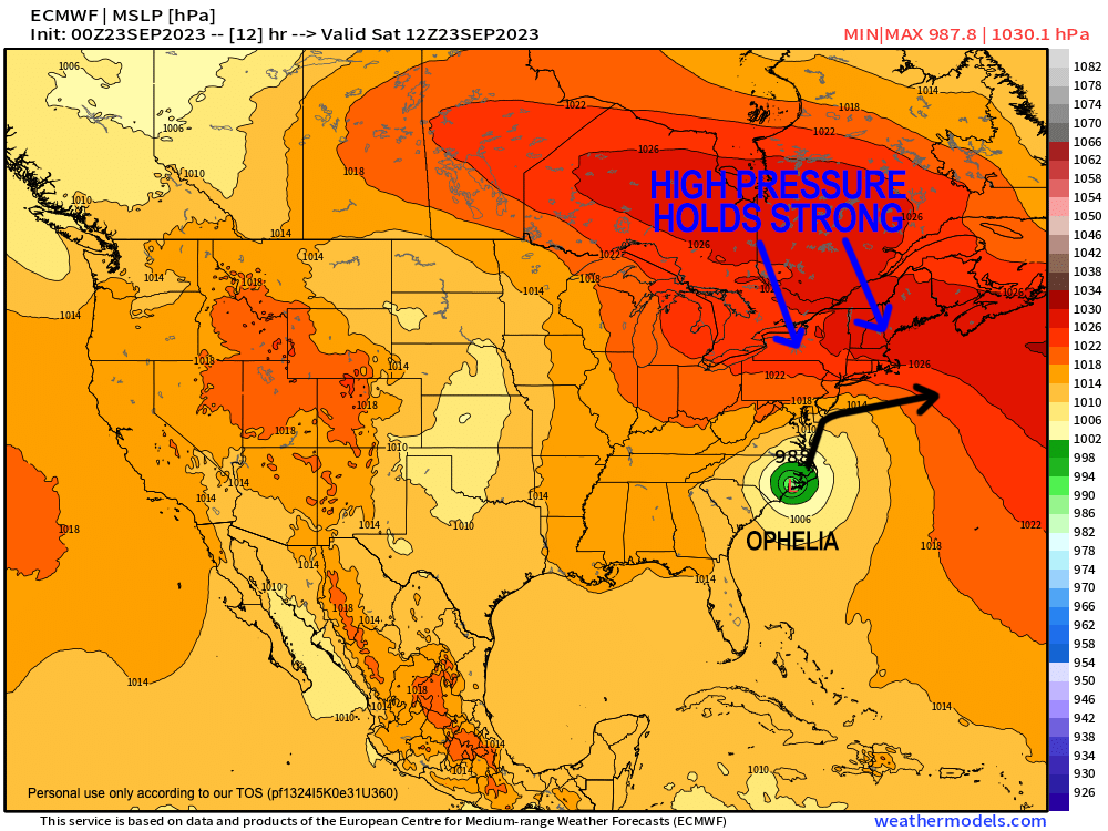
Good morning everybody, Ophelia made landfall at Emerald Isle, NC as a strong Tropical Storm overnight with max winds at 70mph. It’s never good when a tropical system is flexing as it roars ashore, but at least it didn’t have another 24 hours to develop because it could have surged to a Cat 2 hurricane.
Regardless, our weather this weekend is tied to that storm and how it interacts with high pressure just to our north.
I do think we’re going to get some rainfall in the form of periods of showers up to the level of the MassPike this morning, possible a bit farther north, and not much further north than the Route 2 corridor this afternoon and evening.
BUST POTENTIAL
This forecast could bust drier if high pressure to our north overwhelms a few of these outer bands tracking north from Ophelia into CT and RI this morning (and south over the waters), as they are well detached from the main area of lift way down the east coast.
Overall, it will be drier north of the Pike and wetter south of it, and unfortunately with these sharp northern cutoff situations, I will not be able to tell you what you can expect in your zip code, although I do make an effort to do so when I can.
Highs under cloudy skies today for our first day of Autumn will be… Autumnal! Some in the high terrain will remain in the 50s, with low 60s for the valley!
If you make soup I want pics!!
For tonight, showers will weaken and some drizzle is possible with lows either side of 50º.
On Sunday, our storm makes its closest pass and we should see some more rain showers at times, especially south of the Rt. 2 corridor, heaviest south of the Pike.
Highs will reach the upper 50s to mid 60s with lows near 50º and a few showers possible.
Any Monday morning showers should abate, although some signals exist for a final flex of rainfall before Ophelia’s remnants skedaddle out of town.
Thereafter, a sprawling, massive dome of high pressure out of Canada will drift toward and into New England.
This will provide abundant sunshine for next week through Friday (and possibly beyond) with highs in the 60s and lows in the 40s, with the potential to crest the 70º mark by late week.
Buh bye Summah, we never really knew ye.
I will update later today on this weekend’s wet weather potential, have a great day!
>>> BE KIND <<<
“Hello babies. Welcome to Earth. It’s hot in the summer and cold in the winter. It’s round and wet and crowded. On the outside, babies, you’ve got a hundred years here. There’s only one rule that I know of, babies: Goddamn it, you’ve got to be kind.”
–Kurt Vonnegut
