[6:25AM SUN: 9/22/24] WELCOME TO AUTUMN! WE DRY TODAY WITH INCREASINGLY SUNNY/BRIGHT CONDITIONS AND LOWER HUMIDITY… FAIR WEATHER EXPECTED THROUGH TUESDAY… SHOWERS DEVELOP WEDNESDAY, AND SUBSTANTIAL RAIN POSSIBLE BY THURSDAY INTO EARLY FRIDAY, FOLLOWED BY TEMPERATE, FAIR WEATHER… WATCHING THE POTENTIAL FOR A TROPICAL SYSTEM IN THE FIRST WEEK OF OCTOBER…

TABLE OF CONTENTS
* Daily Celestials (Sun/Moon Data)
* Sponsor Section
* Morning Discussion
* TIP: Scroll to your section, or read all
~~~~~~~~~~~~~~~~~~~~~~
YOUR DAILY CELESTIALS
~~~~~~~~~~~~~~~~~~~~~~
STAR:
–OUR STAR ROSE AT: 6:38am this morning
–OUR STAR WILL SET AT: 6:46pm this evening
–TOTAL DAYLIGHT TIME: 12 hours and 8 minutes
***Autumnal Equinox Today***
MOON:
–OUR MOON WILL RISE AT: 9:20pm tonight
–MOON RISE DIRECTION: Northeast
–OUR MOON WILL SET AT: 1:37pm tomorrow afternoon
–MOON SET DIRECTION: Northwest
–MOON PHASE: Waning Gibbous (75.1%)
~~~~~~~~~~~~~~~~~~~~~~
>>> A NOTE FROM OUR WEEKEND SPONSOR <<<
Dave Hayes The Weather Nut is Sponsored by Individual Community Members, Patrons, and Gerard, Ghazey & Bates, P.C. GGBPC is a Northampton-based law firm regarded as the voice of pragmatic and well-reasoned estate planning, elder law and tax guidance in Western Massachusetts. The firm specializes in estate planning law, and expertly handles other matters such as Elder Law, Tax Law, as well as Real Estate purchase, sales, and refinance transactions. Contact GGBPC today to see how they can help!
~~~~~~~~~~~~~~~~~~~~~~
YOUR MORNING DISCUSSION
~~~~~~~~~~~~~~~~~~~~~~
Good morning everybody, our multi-day EMass / RI storm is finally ending today, and ended up producing a tenth of an inch up to an inch of rainfall in eastern portions of CMass and eastern most CT.
Otherwise, we saw a few isolated showers in parts of the greater WMass region (mostly yesterday) but most of us stayed dry, and dry we wil continue to stay until at least the middle of this coming week.
For today, we are in a drying phase as the ocean storm is already pulling away to the southeast, and so we should expect mostly sunny skies to develop with time along and west of the Pioneer Valley, and partly sunny skies east of there with highs in the mid 60s to low 70s.
Lows tonight will drop into the mid to upper 40s with an onshore easterly or northeasterly wind developing.
On Monday and Tuesday, that persistent onshore wind due to the combined influence of ocean low pressure to our southeast and high pressure to our northeast will cool our temps and produce some clouds, resulting in partly sunny skies with perhaps some mostly cloudy periods by Tuesday.
HIgh temps will reach only into the 60s Monday and more like 65-70º by Tuesday, with lows in the 40s Monday night and then the upper 40s to low 50s by Tuesday night as clouds thicken up.
By mid-week, we’ll see an upper low and frontal system tracking east out of the Great Lakes region and heading for New England.
This should spread some scattered showers into the greater WMass region during the day, as highs only crawl up into the upper 50s to mid 60s for highs, quite cool!
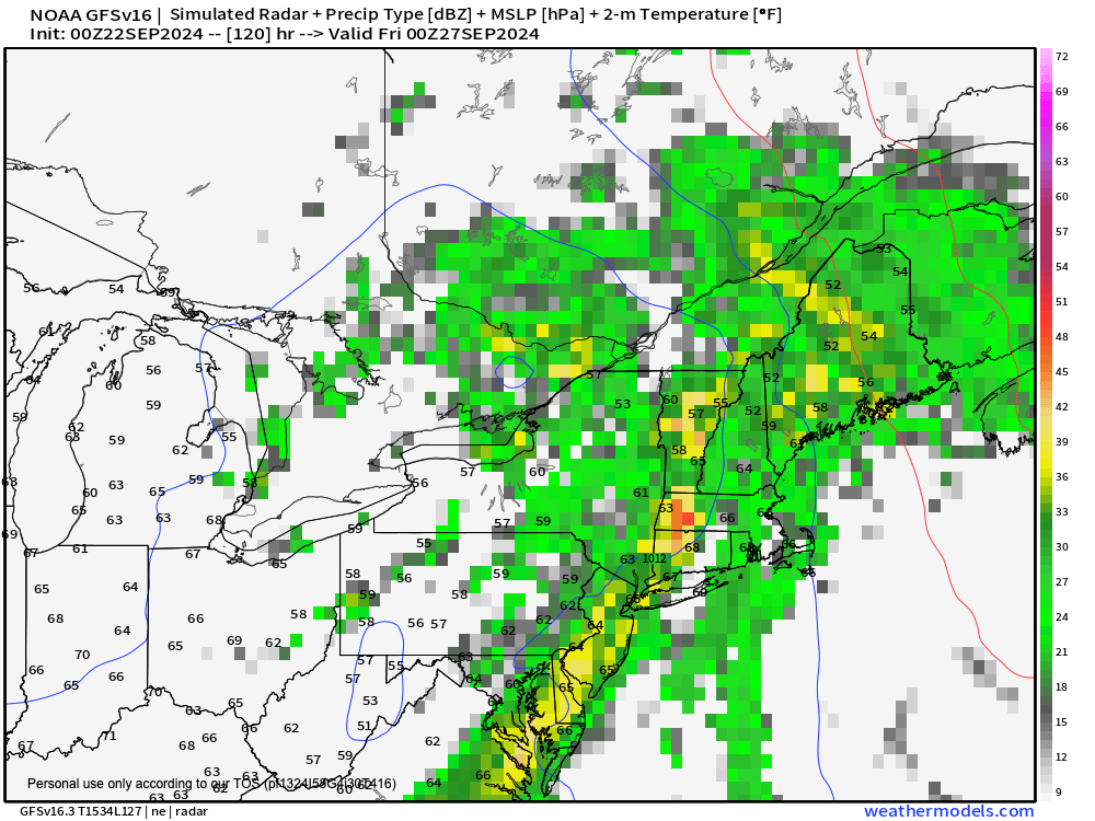
By Wednesday night into Thursday we could see heavier and/or steadier rainfall as the front pushes closer (see attached graphic). Highs will only reach the 60s on Thursday as well.
While showers may linger into part of Friday, as of now, it looks like a drying and slight warming trend will begin later Friday and through the weekend with highs potentially climbing into the mid 60s to low 70s.
Beyond that, the tropics may be starting to heat up, so stay tuned for updates as we push toward the colorful month of October!
Have a great day!
HAIKU OF THE DAY:
Rain dearth got you down?
You look like you need more sun
Here, have more helpings
“Follow your bliss and the universe will open doors for you where there were only walls.”
― Joseph Campbell
