
TABLE OF CONTENTS
* Daily Celestials (Sun/Moon Data)
* Sponsor Section
* Morning Discussion
* TIP: Scroll to your section, or read all
~~~~~~~~~~~~~~~~~~~~~~
YOUR DAILY CELESTIALS
~~~~~~~~~~~~~~~~~~~~~~
STAR:
–OUR STAR ROSE AT: 6:37am this morning
–OUR STAR WILL SET AT: 6:48pm this evening
–TOTAL DAYLIGHT TIME: 12 hours and 11 minutes
MOON:
–OUR MOON WILL RISE AT: 8:40pm this evening
–MOON RISE DIRECTION: East-Northeast
–OUR MOON WILL SET AT: 12:24pm tomorrow morning
–MOON SET DIRECTION: Northwest
–MOON PHASE: Waning Gibbous (83.9%)
~~~~~~~~~~~~~~~~~~~~~~
>>> A NOTE FROM OUR WEEKEND SPONSOR <<<
Dave Hayes The Weather Nut is Sponsored by Individual Community Members, Patrons, and Gerard, Ghazey & Bates, P.C. GGBPC is a Northampton-based law firm regarded as the voice of pragmatic and well-reasoned estate planning, elder law and tax guidance in Western Massachusetts. The firm specializes in estate planning law, and expertly handles other matters such as Elder Law, Tax Law, as well as Real Estate purchase, sales, and refinance transactions. Contact GGBPC today to see how they can help!
~~~~~~~~~~~~~~~~~~~~~~
YOUR MORNING DISCUSSION
~~~~~~~~~~~~~~~~~~~~~~
Good morning everybody, our ocean storm keeps lashing eastern MA and the Cape and Islands with rainfall and wind, quite the multi-day nor’easter!
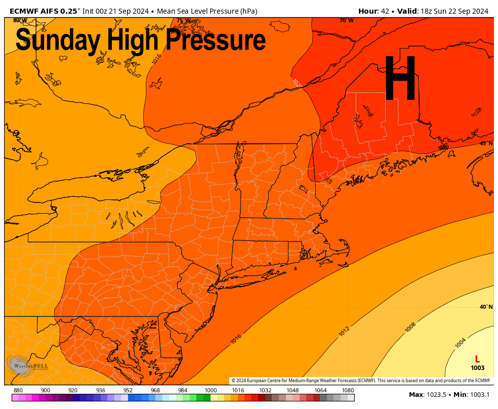
For us, as mentioned yesterday I believe, that storm makes its closest pass to the WMass region by retrograding (i.e. tracking west toward Nantucket) today, and then getting shunted south and southeast and out to sea by high pressure in eastern Canada.
This has pushed showers westward into central MA and northeast CT, but showers are having a hard time getting much past easternmost portions of WMass due to drier air, and simply the position of the low center.
While some showers are possible into the Pioneer Valley, we should see any such activity this morning, and then watch showers pull back south and east through the afternoon and evening as high pressure drops south out of eastern Canada and pushes the storm, finally, out to sea.
Definitely a showery CMass Saturday down into northeast CT for a time, to be sure.
Highs reach the upper 60s to low 70s under mostly cloudy skies, with some sunny breaks from the valley west, with a partially sunny day in the Berkshires. Lows drop to either side of 50º under decreasing clouds
Sunday is looking lovely with partly sunny skies and highs in the 65-70º range, with chilly lows firmly in the 40s.
Monday brings us another partly sunny day with high pressure’s influence with highs again reaching the 65-70º range. However, clouds will slowly be building into mid week and covering the skies more than our beloved scattered blue light rays will.
By mid week into Thursday, a frontal system with an upper low pushes east and may bring some needed rainfall into the greater WMass region by Thursday, possibly lasting into Friday.
Highs will generally reach the 65-70º range next week with lows either side of 50º as our recent warmth retreats, allowing a new pattern to set up for now.
By the following weekend we may even see some tropcial remnants up this way, so stay tuned.
Have a great day!
HAIKU OF THE DAY:
Finally a spritz
A breeze, a cloud, a storm hint
Close but no cigar
“Follow your bliss and the universe will open doors for you where there were only walls.”
― Joseph Campbell