[7:11AM WED 10/9/24] A COLD FRONT BRINGS SOME SHOWERS THIS EVENING AND GUSTIER WIND TONIGHT INTO THURSDAY WITH HIGHS ONLY IN THE 50S AND OUR FIRST BLUSTERY HIT FOR TOMORROW… FIRST FROST FOR SOME HITS FRIDAY MORNING, THEN TEMPS REBOUND INTO SATURDAY WITH A SUNNY FRI/SAT… SUNDAY STARTS DRY, BUT A STORM SHOULD BRING SOME SHOWERS SUNDAY NIGHT INTO EARLY MONDAY… MUCH COOLER NEXT WEEK WITH FAIR WEATHER EARLY ON, AND POTENTIAL FOR HARD FREEZE… DAVE’S FINAL 2025 WEATHER CALENDAR IS ON SALE NOW…

Dave’s 2025 Weather Wall Calendar packs a lot of goodies into one piece (click below to securely order):
~ Colorful Local Photos & Educational Content
~ WMass Community-Oriented & Contemplative
~ Affordable, Useful, & Practical
~ Great for holiday gifts (order info below)
~~~~~~~~~~~~~~~~~~~~~~
TABLE OF CONTENTS
* Daily Celestials (Sun/Moon Data)
* Sponsor Note
* DHTWN Announcements
* Morning Discussion
* TIP: Scroll below for sections, or read all
~~~~~~~~~~~~~~~~~~~~~~
YOUR DAILY CELESTIALS
~~~~~~~~~~~~~~~~~~~~~~
STAR:
–OUR STAR ROSE AT: 6:56am this morning
–OUR STAR WILL SET AT: 6:17pm this evening
–TOTAL DAYLIGHT TIME: 11 hours and 21 minutes
MOON:
–OUR MOON WILL RISE AT: 1:54pm this morning
–MOON RISE DIRECTION: Southeast
–OUR MOON WILL SET AT: 10:16pm this evening
–MOON SET DIRECTION: Southwest
–MOON PHASE: Waxing Crescent (36.4%)
~~~~~~~~~~~~~~~~~~~~~~
A NOTE FROM OUR SPONSOR
~~~~~~~~~~~~~~~~~~~~~~
Dave Hayes The Weather Nut is Sponsored by Individual Community Members, Patrons, and Tandem Bagel Company… No matter the weather, Tandem Bagel is always there for you at several valley locations to make your mornings brighter! With *New Pizza Bagels(!)*, along with bagels baked fresh daily (including Gluten-Free options), house-whipped cream cheese, coffee, and tons of lunch options, Tandem is the perfect quick stop for lunch, breakfast, or a coffee and bagel to go.
You can either 1) visit them in Easthampton, Northampton, Hadley, Florence, and/or West Springfield, 2) hire them to cater your next event, or 3) use their super-streamlined online ordering tool by visiting their website and clicking the “Catering” or “Order Online” links.
~~~~~~~~~~~~~~~~~~~~~~
DHTWN ANNOUNCEMENTS
~~~~~~~~~~~~~~~~~~~~~~
1. News on Dave’s Upcoming Mobile Weather App
(Late 2024 Release)
2. 2025 DHTWN Weather Wall Calendar
(Securely Order via Cards, Venmo, PayPal, or Check)
~~~~~~~~~~~~~~~~~~~~~~
YOUR MORNING DISCUSSION
~~~~~~~~~~~~~~~~~~~~~~
Good morning folks, we’re still hurtling through the Cosmos together on this spinny blue ball which will eventually be swallowed up by our star as it expands into a red giant in about 5 billion years, but for now, our yellow-white orb will behave for a little while longer.
Speaking of behaving, we’re very very very fortunate in that our New England weather is well behaved (meaning, not out of control like NC and FL).
We’re moving into deeper Autumn at this stage (not that we can’t see a couple more warm-ups this Fall), and cooler temps are starting to show up.
For today, any patchy dense fog noted along northern MA and into SVT and SWNH will burn off with time and we’ll develop a partly sunny day with highs in the upper 50s to mid 60s.
However, a shortwave and cold front will be swinging through the region later today and tonight thanks to an upper level trough over us currently which will continue to pull east toward Atlantic Canada.
This feature should help turn our skies from partly sunny to mostly cloudy later this afternoon and tonight, with a period of some showers between say 6pm and midnight as the front moves through.
Showers are most likely along and west of the Pioneer Valley, but some will translate east of there, too, and don’t be surprised if you live above 2000 feet in southern VT to see a few snowflakes mixed in after sunset!
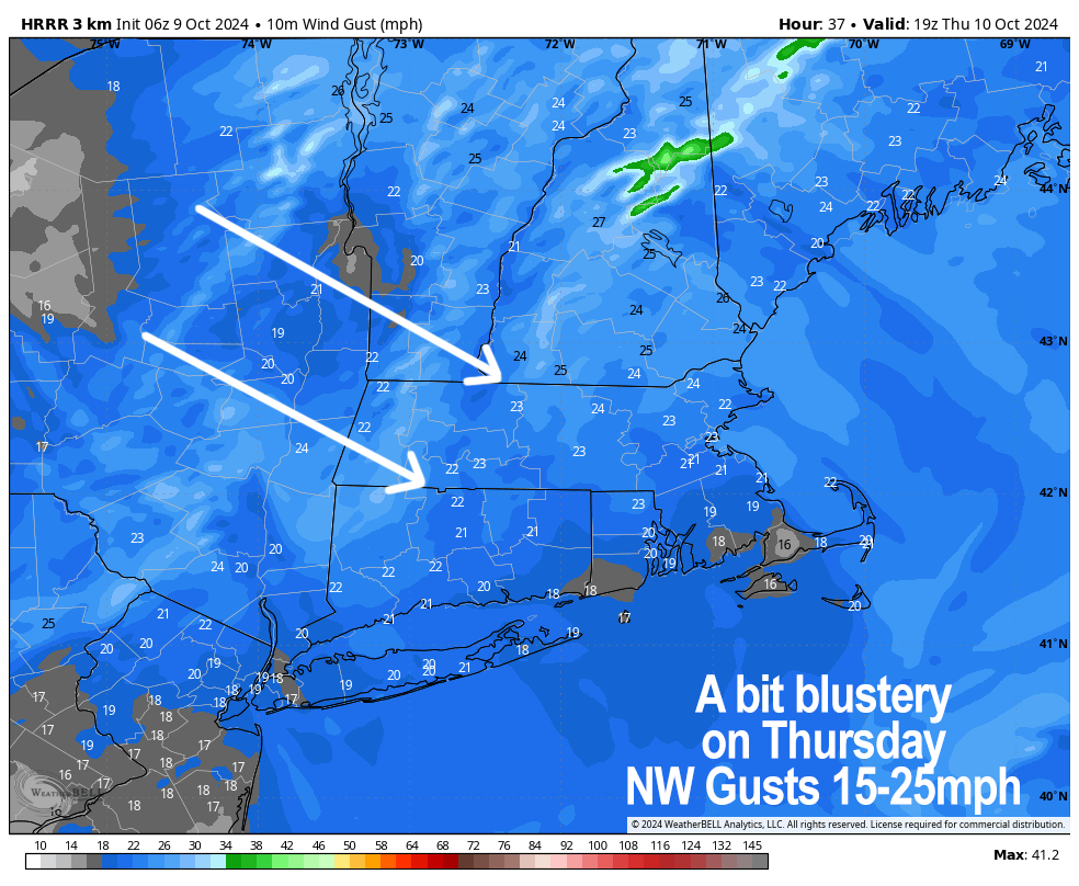
Northwest winds are going to come in with this front and behind it, so I expect gusts of 15-25mph later tonight and on Thursday.
Lows will drop to either side of 40º, and highs will only be in the 50s tomorrow with sunny skies for the entire region, so our first blustery hit is on the way with breezy conditions and cooler air.
Once the wind blows through and skies clear, it’ll be quite dry Thursday night, and this will allow for radiational cooling to better maximize, with lows temps expected the mid to upper 30s, so some folks should see patchy frost in parts of our region by early Friday morning.
Temps rebound as high pressure starts to pass south of us Friday and Saturday creating a more west to east (i.e. zonal) flow vs. northwest to southeast, and highs should reach the low to mid 60s Friday and mid to upper 60s on Saturday under mostly sunny skies with lows in the 40s.
By Sunday, a storm will be setting up to our west, though there is still uncertainty with its ultimate track and strength.
It should produce more clouds and cooler temps by Sunday (highs low to mid 60s), and showers are expected by Sunday night into Monday, though I will have to refine that as we get closer.
The bottom line is that behind that storm another stronger shot of colder air will be directed from Canada into the greater WMass region most likely with 50s for highs and 30s for lows, with a chance for some folks to dip into the upper 20s by the middle of next week, so more frost and a potential hard freeze is looking more likely at the moment.
I will keep you updated… have a great day and please buy my calendar if you need one, or need to do some holiday gift shopping!
2025 DHTWN Weather Wall Calendar
(Securely Order via Cards, Venmo, PayPal, or Check)
“Follow your bliss and the universe will open doors for you where there were only walls.”
― Joseph Campbell
