Dave’s 2025 Weather Wall Calendar packs a lot of goodies into one piece:
~ Colorful Local Photos & Educational Content
~ WMass Community-Oriented & Contemplative
~ Affordable, Useful, & Practical
~ Great for holiday gifts (order info below)
2025 DHTWN Weather Wall Calendar
(Securely Order via Cards, Venmo, PayPal, Check)
TABLE OF CONTENTS
* Daily Celestials (Sun/Moon Data)
* Sponsor Section
* Morning Discussion
* TIP: Scroll to your section, or read all
~~~~~~~~~~~~~~~~~~~~~~
YOUR DAILY CELESTIALS
~~~~~~~~~~~~~~~~~~~~~~
STAR:
–OUR STAR ROSE AT: 6:53am this morning
–OUR STAR WILL SET AT: 6:22pm this evening
–TOTAL DAYLIGHT TIME: 11 hours and 29 minutes
MOON:
–OUR MOON WILL RISE AT: 10:47am this morning
–MOON RISE DIRECTION: East-Southeast
–OUR MOON WILL SET AT: 7:56pm this evening
–MOON SET DIRECTION: Southwest
–MOON PHASE: Waxing Crescent (12.1%)
~~~~~~~~~~~~~~~~~~~~~~
>>> A NOTE FROM OUR WEEKEND SPONSOR <<<
Dave Hayes The Weather Nut is Sponsored by Individual Community Members, Patrons, and Gerard, Ghazey & Bates, P.C. GGBPC is a Northampton-based law firm regarded as the voice of pragmatic and well-reasoned estate planning, elder law and tax guidance in Western Massachusetts. The firm specializes in estate planning law, and expertly handles other matters such as Elder Law, Tax Law, as well as Real Estate purchase, sales, and refinance transactions. Contact GGBPC today to see how they can help!
~~~~~~~~~~~~~~~~~~~~~~
YOUR MORNING DISCUSSION
~~~~~~~~~~~~~~~~~~~~~~
Good morning everybody, it sure feels and felt like Fall this morning, and a lovely day lies ahead.
Highs in the 65-70º range will cover most of us, but some low 60s are possible in the western hilltowns and areas north.
Clouds will increase tonight, likely after sunset and lows should bottom out into the low 50s as the cloud deck will keep temps milder overnight.
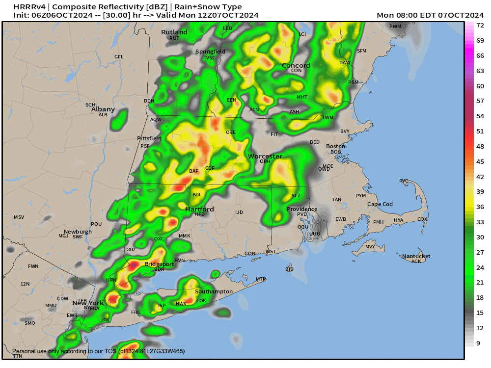
A cold front will be slicing through NY state and headed into New England for Monday morning, and we’ll likely see first showers after midnight during the pre-dawn hours.
Rain should showers should become steadier and heavier at times during the morning commute and through late morning, when a couple of thunderstorms will also be possible.
In other words, don your rain gear tomorrow morning when you head out the door, if you can remember where you stowed it!
———————
LARRY PICARD RE: DAVE’S WMASS WEATHER CALENDAR
“Thoughtful, beautiful, and the essence of what makes western Mass what it is. Dave’s calendar is the perfect wall calendar and supports one of the things we love best about western Massachusetts: Dave Hayes and his accurate, colorful, and entertaining weather reports.”
———————
Highs Monday will reach well into the 60s and rain should quit by early afternoon, maybe lasting into mid afternoon for CMass and northeast CT.
For us here in WMass, northwest CT and southern VT we should see at least partial sunshine develop as the afternoon wears on, as this front will keep cooking on to the east with nothing to slow it down.
Lows Monday night will drop to either side of 40º as we clears skies out, especially later in the evening.
The Tuesday through Saturday stretch looks quite dry!
We’ll start off Tuesday through Friday with cooler temps as an upper level trough establishes itself over the northeast U.S.
Highs should only climb to the mid 50s to low 60s during this period, with 50s in the high terrain and low 60s in the valley areas south and east.
Lows Tuesday, Wednesday and Thursday night will be the coldest of this pattern change period, with lows in the mid to upper 30s and a chance for some patchy frost especially Wednesday and/or Thursday morning.
This upcoming cooler period will not last, by the way. It’s a glancing blow, a first autumnal taste, but there’s not enough cold air in Canada built up yet, nor will the steering pattern keep a persistent northwest flow into New England past this week.
It looks like plenty of sunshine and mostly clear nights are on the way, and then high pressure will track south of us, and reassert a more southwest flow which will warm us into the 60-65º range on Friday, and then the 65-70º range over the weekend, which for now looks quite pleasant.
Have a great day, and remember that if you love the western MA region and want to bring one or more my colorful, educational, practical, gift-y Weather Wall Calendars into your or someone else’s life, be sure to click below to learn more or to order:
2025 DHTWN Weather Wall Calendar
(Securely Order via Cards, Venmo, PayPal, or Check)
HAIKU OF THE DAY:
Buh bye space weather
Earth weather is hard enough
A nothing burger
“Follow your bliss and the universe will open doors for you where there were only walls.”
― Joseph Campbell
