
2023 WEATHER WALL CALENDAR AVAILABLE TO ORDER:
–Serene and gorgeous local photos
–Deep-drive regional storm histories, stories, and the meteorology involved
–Weather-themed haiku
–Featured article on how the Sun drives Earth’s weather, and much more!
Good morning folks, after plentiful rains for some and lighter rains for others, Hurricane Ian and its rainy remnants are finally OUTTA HERE! Late-season warmth is ours for two days with some showers and frost potential, too, but before we jump into the details, let’s check a note from our local and delicious sponsor, #TandemBagelCo, with their newest location in West Springfield, MA.
——————–
A NOTE FROM OUR SPONSOR:
DHTWN Is Sponsored by Members, Patrons & Tandem Bagel Company: No matter the weather, Tandem Bagel is always there for you at several valley locations to make your mornings brighter! With bagels baked fresh daily, house-whipped cream cheese, coffee, and tons of lunch options, Tandem is the perfect quick stop for lunch, breakfast, or a coffee and bagel to go. Find them in Easthampton, Northampton, Hadley, Florence, and West Springfield, or use their super-streamlined online ordering tool by visiting their website: https://www.tandembagelco.com
——————————————-
***DHTWN DAILY WEATHER REPORT***
——————————————-
NWS ALERTS
–None
DHTWN REMINDER
–The odds of being a human is 1 in 400 trillion… make it count, even in a small way (see Kurt Vonnegut quote at end of post)
DAILY CELESTIAL (STAR):
–OUR STAR ROSE AT: 6:52am this morning
–OUR STAR WILL SET AT: 6:23pm this evening
–TOTAL DAYLIGHT TIME: 11 hours and 31 minutes
DAILY CELESTIAL (MOON):
–OUR MOON WILL RISE AT: 5:16pm this afternoon
–OUR MOON WILL SET AT: 4:01am tomorrow morning
–MOON RISE DIRECTION: East-Southeast
–MOON SET DIRECTION: West-Southwest
–MOON PHASE: Waxing Gibbous (85.6%)
———————-
DAILY TERRESTRIAL (ZoneCast)
ZONE 1 (Northern Region)
Southern VT, Southwest NH, N. Taconics NY
–High Temps: Low to Mid 70s
–Low Temps: Low 50s
–Humidity: Comfortable
–Wind: Light northerly backing to westerly, calm at times
–Skies: Mostly Sunny
–Precipitation: None today, though a few showers pre-dawn Friday hours possible
ZONE 2 (Central Region)
WMass, N. CMass, N. Litchfield County, C./S. Taconics NY
–High Temps: Low to Mid 70s
–Low Temps: Low 50s
–Humidity: Comfortable
–Wind: Light northerly backing to westerly, calm at times
–Skies: Mostly Sunny
–Precipitation: None today, though a few showers pre-dawn Friday hours possible
ZONE 3 (Southern Region)
S. CMass, S. Litchfield County, NC.CT, & NE.CT
–High Temps: Low to Mid 70s
–Low Temps: Low 50s
–Humidity: Comfortable
–Wind: Light northerly backing to westerly, calm at times
–Skies: Mostly Sunny
–Precipitation: None today, though a few showers pre-dawn Friday hours possible
———————-
WEATHER REPORT
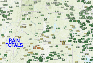
Good morning everybody, that rainy, stuck pattern has been broken as an incoming cold front for tomorrow has swept that established, vertically-stacked, made-its-own-steering-flow remnant low center from Ian out to sea, buh bye!
We got some beneficial rainfall, though, and if you’ll remember I had said a month or two ago that that (unfortunately) is one of the main ways we dent or break New England droughts, and so it is with that system.
Not that the drought is “broken”, but we put another good dent in it, and we’re moving in the right direction.
But for now, it’s tons of sun straight ahead!
An area of higher pressures will move in today and produce highs in the low to mid 70s with lows in the low 50s as clouds increase tonight.
Another pre-frontal trough will move in during the early Friday morning hours and bring a few showers to the region, but will be seeing continued warming flow from the west and west-southwest behind it.
Highs again rise into the low to mid 70s, and then a cold front slices through by late afternoon with more scattered showers, and maybe a downpour.
This will usher in much cooler air for the weekend, and northwest winds will gust up to 20mph at times as lows plummet into the 35-40º range. However, with breezy conditions overnight, we shouldn’t see any frost, save for a few SVT patches.
On Saturday, it’s full on Autumn with highs in the low to mid 50s under bright sunshine with light northwest wind.
Saturday night should be clear, dry and calm, which means Frost Advisories may need hoisting by the NWS, I will keep you updated. Lows should dip into the low to mid 30s.
Sunday is sunny, with highs 55-60º and lows in the upper 30s, and fair weather looks to continue through mid week with highs in the upper 50s to mid 60s and lows in the upper 30s to mid 40s as strong high pressure rules our roost.
We could see a strong storm or frontal boundary with a storm along it bring more rainfall by late week on next Friday, but I will update you as we get closer!
Have a great day, and please check out my 2023 calendar, it’s a great local-color-filled daily companion, you’ll learn a bunch of cool local weather history, and it’s great for holiday gifts too!
Did you know that you can also follow me on Twitter?
AND REMEMBER…
“Hello babies. Welcome to Earth. It’s hot in the summer and cold in the winter. It’s round and wet and crowded. On the outside, babies, you’ve got a hundred years here. There’s only one rule that I know of, babies: Goddamn it, you’ve got to be kind.”
–Kurt Vonnegut