
2023 WEATHER WALL CALENDAR AVAILABLE TO ORDER:
–Serene and gorgeous local photos
–Deep-drive regional storm histories, stories, and the meteorology that produced them
–Weather-themed haiku
–Featured article on how the Sun drives Earth’s weather, and much more…
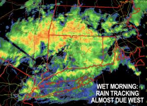
Good morning folks, we’ve got our spinning vertically-stacked low center south of us and due east of the DelMarVa Peninsula developing rain and some thunder this morning and tracking it west through the region.
We have cool and rainy conditions at times today, followed by warmer and sunnier days for Thursday and Friday before a Canadian cold front drives blustery and cooler conditions in here over the weekend, with a Mildening expected by early next week, but before we jump into the details, let’s check a note from our local and delicious sponsor, #TandemBagelCo, with their newest location in West Springfield, MA.
——————–
A NOTE FROM OUR SPONSOR:
DHTWN Is Sponsored by Members, Patrons & Tandem Bagel Company: No matter the weather, Tandem Bagel is always there for you at several valley locations to make your mornings brighter! With bagels baked fresh daily, house-whipped cream cheese, coffee, and tons of lunch options, Tandem is the perfect quick stop for lunch, breakfast, or a coffee and bagel to go. Find them in Easthampton, Northampton, Hadley, Florence, and West Springfield, or use their super-streamlined online ordering tool by visiting their website: https://www.tandembagelco.com
——————————————-
***DHTWN DAILY WEATHER REPORT***
——————————————-
NWS ALERTS
–Flood Advisory until 8:45am for southern Berkshires, northwest Litchfield County CT and the adjacent southern Taconics for potential street flooding
DHTWN REMINDER
–The odds of being a human is 1 in 400 trillion… make it count, even in a small way (see Kurt Vonnegut quote at end of post)
DAILY CELESTIAL (STAR):
–OUR STAR ROSE AT: 6:51am this morning
–OUR STAR WILL SET AT: 6:25pm this evening
–TOTAL DAYLIGHT TIME: 11 hours and 34 minutes
DAILY CELESTIAL (MOON):
–OUR MOON WILL RISE AT: 4:46pm this afternoon
–OUR MOON WILL SET AT: 2:45am tomorrow morning
–MOON RISE DIRECTION: East-Southeast
–MOON SET DIRECTION: West-Southwest
–MOON PHASE: Waxing Gibbous (76.6%)
———————-
DAILY TERRESTRIAL (ZoneCast)
ZONE 1 (Northern Region)
Southern VT, Southwest NH, N. Taconics NY
–High Temps: Upper 50s to Mid 60s
–Low Temps: Low to Mid 40s
–Humidity: Moist
–Wind: Light northerly wind
–Skies: Mostly Cloudy
–Precipitation: Occasional showers
ZONE 2 (Central Region)
WMass, N. CMass, N. Litchfield County, C./S. Taconics NY
–High Temps: Upper 50s to Low 60s
–Low Temps: Mid to Upper 40s
–Humidity: Moist
–Wind: Light northerly wind
–Skies: Mostly Cloudy
–Precipitation: Rain, heavy at times this morning, especially south of Rt. 2 corridor… a lull mid/late morning, then more showers later this afternoon and early evening, quitting by midnight
ZONE 3 (Southern Region)
S. CMass, S. Litchfield County, NC.CT, & NE.CT
–High Temps: Mid to Upper 50s
–Low Temps: Upper 40s to Low 50s
–Humidity: Moist
–Wind: Light northerly wind
–Skies: Mostly Cloudy
–Precipitation: Rain, heavy at times this morning… a lull mid/late morning starting earlier in northeast CT, then more showers later this afternoon and early evening, quitting by midnight
———————-
WEATHER REPORT
Good morning everybody, we have a rainy early morning period in progress, but we should get a lull in the action later this morning with more widely scattered, lighter showers before a reprieve of more activity later today and early tonight before this system finally vamooses to the east, swept away by an incoming area of high pressure and then a cold front by Friday afternoon.
Some street flooding is possible early this morning in southern areas of WMass and northwest CT, given that an area of stronger mid-level lapse rates passed overhead there which allowed convection to develop and produce heavier showers, with thunder in some areas.
We’ve received small amounts of rain along and north of the Rt. 2 corridor, but south of there, and especially in southern MA and northern CT up to 2″ of rain has fallen since yesterday.
This old tropical system fired back up last night and brought the lion’s share of those totals to our region along with some thunder overnight in a few spots.
After our lull later this morning, more scattered showers will move back in during the afternoon and evening, again steadiest/heaviest south of the Rt. 2 corridor in MA and CT.
Highs today will reach the upper 50s to low 60s with lows in the mid 40s as rain quits sometime around midnight and pulls east and out to sea. Patchy fog is possible, as well.
For Thursday, a lovely, sunny high pressure day arrives with highs in the upper 60s to low 70s – it’ll literally be like night and day when comparing tomorrow to today!
Clouds will increase at night as a warm front moves into the region with a few early morning showers possible, with lows in the low 50s.
On Friday we’ll see temps rise up to near 70º again before a cold front moves through during the afternoon with much cooler and drier air behind it.
West to northwest breezes will gust to 25mph and lows Friday night will crash into the mid to upper 30s, with said breezes likely keeping frost formation at bay.
For Saturday, expect a breezy day out of the northwest with slackening wind later on with highs in the low to mid 50s under mostly sunny skies and lows in the mid to upper 30s.
Sunday looks like a repeat, but maybe a few degrees milder.
In fact, high pressure looks to dominate through early next week as well with highs in the upper 50s to mid 60s with lows either side of 40º.
It’s going to take until mid to late week to get any additional rain in here, so hopefully we get a nice final batch today to help with the drought, which will move it in the right direction.
Have a great day, and please check out my 2023 calendar, it’s a great local-color-filled daily companion, you’ll learn a bunch of cool local weather history, and it’s great for holiday gifts too!
SECURE CALENDAR ORDER/INFO LINK
Did you know that you can also follow me on Twitter?
AND REMEMBER…
“Hello babies. Welcome to Earth. It’s hot in the summer and cold in the winter. It’s round and wet and crowded. On the outside, babies, you’ve got a hundred years here. There’s only one rule that I know of, babies: Goddamn it, you’ve got to be kind.”
–Kurt Vonnegut