[7:11AM WED 10/2/24] DEEPER AUTUMN ARRIVES NEXT WEEK WITH FIRST FROST POSSIBLE… PATCHY DENSE FOG LIFTS THIS A.M., BEGETTING A PAIR OF EARLY OCTOBER WARM MUFFINS FOR TODAY AND TOMORROW WITH HIGHS IN THE 70S… A FEW SHOWERS EARLY TOMORROW MORNING… GEOMAGNETIC STORM WATCH UP FOR SATURDAY NIGHT FOR AURORA… NICE SUNDAY… SHOWERS SUNDAY NIGHT INTO MONDAY… COOLER AND EVENTUALLY WINDIER NEXT WEEK… MY 10TH ANNIVERSARY / FINAL 2025 WEATHER WALL CALENDAR SALE LAUNCHES TOMORROW… INFO TO HELP FOLKS IN WESTERN NC IS IN THIS POST…

TABLE OF CONTENTS
* Daily Celestials (Sun/Moon Data)
* Sponsor Note
* DHTWN Announcements
* Morning Discussion
* TIP: Scroll below for sections, or read all
~~~~~~~~~~~~~~~~~~~~~~
YOUR DAILY CELESTIALS
~~~~~~~~~~~~~~~~~~~~~~
STAR:
–OUR STAR ROSE AT: 6:51am this morning
–OUR STAR WILL SET AT: 6:25pm this evening
–TOTAL DAYLIGHT TIME: 11 hours and 34 minutes
MOON:
–OUR MOON WILL RISE AT: 8:37am this morning
–MOON RISE DIRECTION: East-Southeast
–OUR MOON WILL SET AT: 7:04pm this evening
–MOON SET DIRECTION: West-Southwest
–MOON PHASE: Waxing Crescent (2.5%)
~~~~~~~~~~~~~~~~~~~~~~
A NOTE FROM OUR SPONSOR
~~~~~~~~~~~~~~~~~~~~~~
Dave Hayes The Weather Nut is Sponsored by Individual Community Members, Patrons, and Tandem Bagel Company… No matter the weather, Tandem Bagel is always there for you at several valley locations to make your mornings brighter! With *New Pizza Bagels(!)*, along with bagels baked fresh daily (including Gluten-Free options), house-whipped cream cheese, coffee, and tons of lunch options, Tandem is the perfect quick stop for lunch, breakfast, or a coffee and bagel to go.
You can either 1) visit them in Easthampton, Northampton, Hadley, Florence, and/or West Springfield, 2) hire them to cater your next event, or 3) use their super-streamlined online ordering tool by visiting their website and clicking the “Catering” or “Order Online” links.
~~~~~~~~~~~~~~~~~~~~~~
DHTWN ANNOUNCEMENTS
~~~~~~~~~~~~~~~~~~~~~~
~ News on Dave’s Upcoming Mobile Weather App
(Late 2024 Release)
~ Subscribe to Dave’s Weekly Newsletter
(Get the free 70-page ebook: Top 15 WMass Storms!)
~~~~~~~~~~~~~~~~~~~~~~
YOUR MORNING DISCUSSION
~~~~~~~~~~~~~~~~~~~~~~
Good morning folks, I want to start by sharing two online resources where you can get more info and/or donate to help folks down in western NC with flood recovery efforts, if you feel so moved.
This could happen to any of us (as I said, the Hurricane of 1938 will likely happen again here in southern New England during my lifetime), and so if you want to help, please check out the following two links.
As for our space weather, we have a Strong Geomagnetic Storm Watch up for tonight through Sunday night for a pair of X-Class flares, so we may get some Aurora viewings in play (tough viewing for tonight and Sunday night with fronts coming in, but Saturday night could be good).
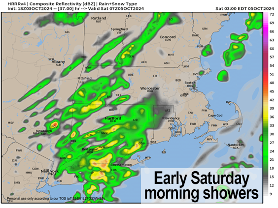
As for our Earth weather, our rain dearth continues with only two chances including overnight tonight into early Saturday with a few showers, and a better chance for a period of rain late Sunday night into Monday morning with a stronger cold front that will issue in more of a persistent northwest flow out of Canada into New England.
This flow change will begin our first deeper descent into Autumn, with cooler temps and gustier conditions at times next week, along with potential for a first frost by late in the week.
As for today, we’re starting off with dense fog in spots, and lighter fog in others, so take it slow to head out the door. Any fog will burn off as a light southwest flow tees us up for a lovely, partly sunny day with highs in the low to mid 70s, so get out and enjoy it!
As for tonight, clouds will increase with a weakening front approaching the region.
Lows will dip into the low to mid 50s with some scattered showers working into the region after midnight, and ending before enoon tomorrow.
This will allow us to get a nice Saturday afternoon I believe, with sunny breaks as the day wears on, which will contribute to highs climbing into the upper 60s to mid 70s.
I say soak these two days up while you can, as I don’t see 70s in the forecast going forward, and while we can’t rule out a climb above 70º in October, this may be the last time we crest that reading until 2025.
Remember, Saturday night may represent a solid aurora viewing chance so stay tuned for further space weather updates.
Highs Sunday should reach the mid to upper 60s (maybe a few folks hit 70º) under sunny skies, and then we will cloud up as a stronger cold front approaches the region for Sunday night into Monday.
I believe a solid area of showers will move through Sunday night into Monday with this stronger front, which represents the leading edge of a more persistent pool of cooler air and northwest flow out of Canada.
Monday looks like highs will be squarely in the low to mid 60s, with lows either side of 40º as we clear out skies out.
By Tuesday through Friday we should experience dry weather with mostly sunny skies, but highs will be noticeably cooler, only in the 50s in the high terrain, and upper 50s to low 60s in the Pioneer Valley points east, with lows in the 30s and 40s.
By mid to late week, another reinforcing shot of cooler air may arrive, dropping us into our first frost by Thursday night, so I will keep you updated.
It’s October, the leaves are turning, and deeper Autumn is on the way, folks.
Have a great day!
“Follow your bliss and the universe will open doors for you where there were only walls.”
― Joseph Campbell
