
2023 WEATHER WALL CALENDAR INFO/ORDER LINK
Good morning folks, we’ve got some legit ocean weather conditions out there this morning with a few peeks of sun to kick off the day.
Am I a freak, because I LOVE this weather?!
Temps are in the upper 30s to 40s with a few scattered showers around this morning, but they’re tracking northwest, which is an unusual direction!
Anyway, we can expect cool temps, breezy conditions, and scattered showers at times today with mostly cloudy skies and a few sunny breaks… better chance of showers tonight and tomorrow with warming temperatures and brightening skies for Thursday and Friday prior to a sharp cold front that pushes through later Friday and cools us right down for the weekend with blustery conditions, but before we jump into the details, let’s check a note from our local and delicious sponsor, #TandemBagelCo, with their newest location in West Springfield, MA.
——————–
A NOTE FROM OUR SPONSOR:
DHTWN Is Sponsored by Members, Patrons & Tandem Bagel Company: No matter the weather, Tandem Bagel is always there for you at several valley locations to make your mornings brighter! With bagels baked fresh daily, house-whipped cream cheese, coffee, and tons of lunch options, Tandem is the perfect quick stop for lunch, breakfast, or a coffee and bagel to go. Find them in Easthampton, Northampton, Hadley, Florence, and West Springfield, or use their super-streamlined online ordering tool by visiting their website: https://www.tandembagelco.com
——————————————-
***DHTWN DAILY WEATHER REPORT***
——————————————-
NWS ALERTS
–None
DHTWN REMINDER
–The odds of being a human is 1 in 400 trillion… make it count, even in a small way (see Kurt Vonnegut quote at end of post)
DAILY CELESTIAL (STAR):
–OUR STAR ROSE AT: 6:50am this morning
–OUR STAR WILL SET AT: 6:26pm this evening
–TOTAL DAYLIGHT TIME: 11 hours and 36 minutes
DAILY CELESTIAL (MOON):
–OUR MOON WILL RISE AT: 4:09pm this afternoon
–OUR MOON WILL SET AT: 1:28am tomorrow morning
–MOON RISE DIRECTION: Southeast
–MOON SET DIRECTION: Southwest
–MOON PHASE: Waxing Gibbous (65.9%)
———————-
DAILY TERRESTRIAL (ZoneCast)
ZONE 1 (Northern Region)
Southern VT, Southwest NH, N. Taconics NY
–High Temps: Mid to Upper 50s
–Low Temps: Low to Mid 40s
–Humidity: Moist
–Wind: North to northeast winds gust up to 25mph at times
–Skies: Mostly Cloudy
–Precipitation: Isolated light showers at times
ZONE 2 (Central Region)
WMass, N. CMass, N. Litchfield County, C./S. Taconics NY
–High Temps: Mid to Upper 50s
–Low Temps: Mid to Upper 40s
–Humidity: Moist
–Wind: North to northeast winds gust up to 25mph at times
–Skies: Mostly Cloudy
–Precipitation: Scattered showers later today and tonight
ZONE 3 (Southern Region)
S. CMass, S. Litchfield County, NC.CT, & NE.CT
–High Temps: Mid to Upper 50s
–Low Temps: Upper 40s to Low 50s
–Humidity: Moist
–Wind: North to northeast winds gust up to 25mph at times
–Skies: Mostly Cloudy
–Precipitation: Scattered showers later today and tonight
———————-
WEATHER REPORT
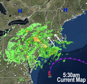
Good morning everybody, we are tasting the ocean later today, tonight and tomorrow, with low pressure due sitting and spinning south of New England for the next two days, and high pressure due north of us.
We’re temporarily locked into what’s called a “Rex Block” which is a high-low pressure pair of systems that dance with and feed into each other for a while, before parting ways.
The greater WMass region is caught between this pair of features, and the result with a low to our south and high to our north is northeasterly winds gusting 15-25mph, and a low pressure center that is hurling scattered showers off of the ocean northwestward into southern New England.
We do have a “kicker” coming by Thursday to give this block the boot out to sea, but for now, it’s cloudy, cool, breezy at times, showery at times, and generally rather raw for early October.
It’ll be drier this morning with a few sunny periods, and more clouds later with highs today only reaching the mid to upper 50s with NE winds gusting up to 25mph at times, making it feel briefly cooler.
Lows tonight will drop into the 40s to low 50s.
Tonight and tomorrow/Wednesday may see a bigger pulse of scattered showers as a final parting shot from Ian The Terrible packs its bags and gets ready to ship east and away.
Highs Wednesday will only reach the upper 50s to low 60s under cloudy skies with more scattered showers and northeast breezes gusting to 20-25mph. Showers will abate at night with lows in the mid 40s.
High pressure moves into the region for Thursday, and so we’re expecting a mostly sunny sky with highs October-soaring into the mid 60s to low 70s! Hooray! Lows will sit down to either side of 50º.
Friday will be sunny, especially in the morning. Thereafter, a cold front will swing through and drop temps overnight into the weekend
Expect one last sweet day on Friday with highs in the 65-70º range, to be followed by lows in the upper 30s to low 40s.
The weekend will be cooler, a bit blustery, but sunny with highs in the 50s Saturday, and upper 50s to near 60º on Sunday with lows in the mid to upper 30s both nights.
Right now, early next week looks to feature fair and milder weather, but I’ll update you on that as we get closer!
Have a great day, and please check out my 2023 calendar, it’s a great local-color-filled daily companion, you’ll learn a bunch of cool local weather history, and it’s great for holiday gifts too!
Did you know that you can also follow me on Twitter?
AND REMEMBER…
“Hello babies. Welcome to Earth. It’s hot in the summer and cold in the winter. It’s round and wet and crowded. On the outside, babies, you’ve got a hundred years here. There’s only one rule that I know of, babies: Goddamn it, you’ve got to be kind.”
–Kurt Vonnegut