Get more when you Order Dave’s 2025 Weather Wall Calendar:
~ An Affordable and Universal Holiday Gift Solution
~ 12 Lovely Local Photos + Cover
~ Lots of Interesting Weather Lessons
~ 12 of my Best Weather-Themed Haiku
~ Much more including tons of celestial info, WMass storms, Holidays etc.
~~~~~~~~~~~~~~~~~~~~~~
TABLE OF CONTENTS
* Daily Celestials (Sun/Moon Data)
* Sponsor Note
* Morning Discussion
* TIP: Scroll below for sections, or read all
~~~~~~~~~~~~~~~~~~~~~~
YOUR DAILY CELESTIALS
~~~~~~~~~~~~~~~~~~~~~~
STAR:
–OUR STAR ROSE AT: 7:22am this morning
–OUR STAR WILL SET AT: 5:44pm this evening
–TOTAL DAYLIGHT TIME: 10 hours and 22 minutes
MOON:
–OUR MOON WILL SET AT: 5:09pm this afternoon
–MOON SET DIRECTION: West-Southwest
–OUR MOON WILL RISE AT: 7:33am tomorrow morning
–MOON RISE DIRECTION: East-Southeast
–MOON PHASE: New Moon (1.1%)
~~~~~~~~~~~~~~~~~~~~~~
A NOTE FROM OUR SPONSOR
~~~~~~~~~~~~~~~~~~~~~~
Dave Hayes The Weather Nut is Sponsored by Individual Community Members, Patrons, and Tandem Bagel Company… No matter the weather, Tandem Bagel is always there for you at several valley locations to make your mornings brighter! With *New Pizza Bagels(!)*, along with bagels baked fresh daily (including Gluten-Free options), house-whipped cream cheese, coffee, and tons of lunch options, Tandem is the perfect quick stop for lunch, breakfast, or a coffee and bagel to go.
You can either 1) visit them in Easthampton, Northampton, Hadley, Florence, and/or West Springfield, 2) hire them to cater your next event, or 3) use their super-streamlined online ordering tool by visiting their website and clicking the “Catering” or “Order Online” links.
~~~~~~~~~~~~~~~~~~~~~~
DHTWN ANNOUNCEMENTS
~~~~~~~~~~~~~~~~~~~~~~
2025 Weather Wall Calendar *Sale Ends 11/10*
(Click/Order via Cards, Venmo, PayPal, Check)
~~~~~~~~~~~~~~~~~~~~~~
YOUR MORNING DISCUSSION
~~~~~~~~~~~~~~~~~~~~~~
Good morning folks, it’s a much milder start this morning, with temps well into the 50s for many and even near 60º for some, so today’s gonna be toasty starting from this level.
We do have some patchy fog located mostly in eastern Franklin County and up into southwest NH this morning with dense fog noted at Keene, NH.
This will burn off more rapidly than yesterday’s fog and low clouds which kept us cooler for longer.
Once that happens, and as an upper ridge presses east with time, strong southwest flow will push temps up into the mid 70s to low 80s under mostly sunny skies.
Trick-or-treaters or Rag-Shag-Parade-Goers will not need extra layers, that’s for sure, as lows by early Friday morning will only sit down into the upper 50s to low 60s!
It will also become breezy overnight with gusts out of the southwest ahead of an incoming cold front with some gusts over 25mph at times, and a few showers into Friday morning.
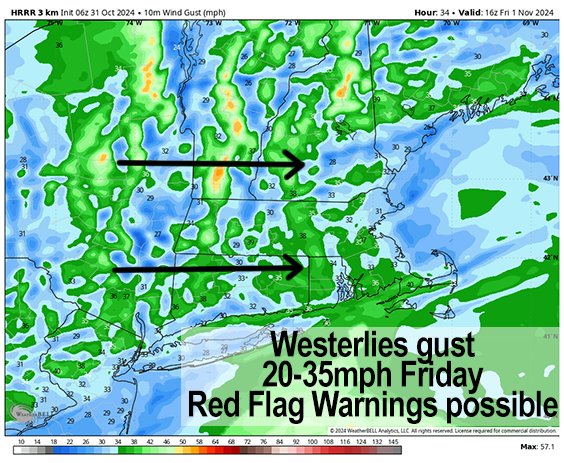
For Friday, showers will clear the region and then we’ll see developing sunshine and gusty westerlies blowing 20-35mph at times, and we can’t rule out some 40mph gusts as well with warm temps expected and highs again in the 70s.
I imagine if this forecast holds, Red Flag Warnings will need hoisting by the NWS to alert folks to the high risk of fire spread given very dry ground, sun, and wind.
Colder air lagging the front moves in Friday night with lows in the 30s to low 40s under partly cloudy skies in the western high terrain and mostly clear skies in the valley points south and east.
The weekend looks seasonable and lovely, with highs in the upper 40s to mid 50s each day and lows either side of 30º at night with mostly sunny/clear skies Saturday night an cloudier skies Sunday night as a warm front approaches.
While I don’t think a warm up like we’re seeing late this week transpires next week, we should see temps become milder but we’ll be stuck in the middle between a warm front and a cold front and how those will interact and where they will layout is still uncertain at this time.
Generally, warmer temps are expected further south in the region, with colder temps toward the north and northeast.
Monday is likely an extension of our weekend weather-wise, with any warming coming into play Tuesday and/or Wednesday with a few showers possible.
Have a great day, and please remember my calendar as you think about your holiday gift shopping, or for yourself (sale ends in 10 days on 11/10):
2025 Weather Wall Calendar
(Securely Order via Cards, Venmo, PayPal, Check)
“Follow your bliss and the universe will open doors for you where there were only walls.”
― Joseph Campbell
