
__________________________________
2023 WEATHER WALL CALENDAR AVAILABLE TO ORDER
–12 Serene and gorgeous local WMass photos
–Featured article on how the Sun drives Earth’s weather
–Deep-dives into the Top 12 most remarkable regional storms including their impacts, my personal stories, and the under-the-hood meteorology that allowed them to form
–12 weather-themed haiku, and much more!
Top of the morning to you all, we have northwest winds already gusting 25-35mph in SVT and the Berkshires and we’ll see increasing sunshine today with drier air and cooler temps to be followed by frosty cold mornings through the weekend with sunshine with some more rain into early next week, but before we jump into the details, let’s check a note from our local and delicious sponsor, #TandemBagelCo, with their newest location in West Springfield, MA.
——————–
A NOTE FROM OUR SPONSOR:
DHTWN Is Sponsored by Members, Patrons & Tandem Bagel Company: No matter the weather, Tandem Bagel is always there for you at several valley locations to make your mornings brighter! With bagels baked fresh daily (including Gluten-Free options), house-whipped cream cheese, coffee, and tons of lunch options, Tandem is the perfect quick stop for lunch, breakfast, or a coffee and bagel to go. Find them in Easthampton, Northampton, Hadley, Florence, and West Springfield, or use their super-streamlined online ordering tool by visiting their website.
——————————————-
***DHTWN DAILY WEATHER REPORT***
——————————————-
NWS ALERTS
–None
DHTWN REMINDER
–The odds of being a human is 1 in 400,000 billion… make it count, even in a small way (see Kurt Vonnegut quote at end of post)
DAILY CELESTIAL (STAR):
–OUR STAR RISES AT: 7:17am this morning
–OUR STAR WILL SET AT: 5:50pm this evening
–TOTAL DAYLIGHT TIME: 10 hours and 33 minutes
DAILY CELESTIAL (MOON):
–OUR MOON WILL SET AT: 7:11pm this evening
–OUR MOON WILL RISE AT: 11:07am tomorrow morning
–MOON SET DIRECTION: West-Southwest
–MOON RISE DIRECTION: Southeast
–MOON PHASE: New Moon / Waxing Crescent (5.1%)
———————-
DAILY TERRESTRIAL (ZoneCast)
ZONE 1 (Northern Region)
Southern VT, Southwest NH, N. Taconics NY
–High Temps: Mid 50s to Low 60s
–Low Temps: Upper 20s to Low 30s
–Wind: Northwest gusts up to 20-30mph, slackening later
–Skies: Mostly Cloudy early with developing sunshine
–Precipitation: None
ZONE 2 (Central Region)
WMass, N. CMass, N. Litchfield County, C./S. Taconics NY
–High Temps: Upper 50s to Low 60s
–Low Temps: Upper 20s to Low 30s
–Wind: Northwest gusts up to 20-30mph, slackening later
–Skies: Mostly Cloudy in the northern Litchfield County, the Berkshires and/or western hilltowns early with developing sunshine
–Precipitation: None
ZONE 3 (Southern Region)
S. CMass, S. Litchfield County, NC.CT, & NE.CT
–High Temps: Upper 50s to Mid 60s
–Low Temps: Low to Mid 30s
–Wind: Northwest gusts up to 20-30mph, slackening later
–Skies: Mostly Cloudy in southern Litchfield County early with developing sunshine
–Precipitation: None
———————-
WEATHER REPORT
Good morning everybody, we’ve got our cold front that’s tracked through the region this morning, draped off of a Quebecer low pressure system which is already kicking our northwest winds up to 35mph in the Berkshires and SVT as drier and cooler air filters into the greater WMass region with time.
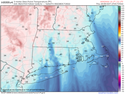
For comparison, we had dewpoint temps WELL into the 60s yesterday, and I even saw a 70º reading or two, which is highly anomalous for this time of year!
Today?
Our dewpoints will be plummeting straight down into the 30s and 40s by this evening with much drier air advecting into the region, so it will be noticeable as our new Canadian air mass overspreads the region.
We have some morning clouds in the Berkshires, Litchfields and SVT (as well as adjacent eastern NY) which may bleed into the valley, but those should give way to partly to mostly sunny skies later today.
Points south and east should see mostly sunny skies developing sooner with highs in the mid 50s to mid 60s from north to south, with northwest winds gusting 20-30mph, and then slackening later.
Lows tonight will bottom out into the mid 20s to mid 30s from north to south, with most of us resting in the upper 20s to low 30s with some frost potential under mostly clear skies with very dry air in place.
For Friday, large high pressure that’s over the Great Lakes today will track east and toward northern new England tomorrow producing plenty of sunshine and highs in the mid to upper 50s with a northerly breeze, and lows mainly in the 20s late Friday night, which will produce a hard freeze.
The weekend looks lovely, with high pressure dominating which will beget mostly sunny skies with highs in the upper 50s to low 60s both days, and lows in the upper 20s to low 30s late Saturday night. Clouds will increase Sunday night resulting in sitting down to around the low 40s for low temps.
A storm system will make a run at us as high pressure kicks east and off of the coastline, which brings periods of showers into our region by early Monday lasting all day and into the night with highs in the low 60s and lows near 50º.
Any early morning Tuesday showers should give way to at least partial sunshine with warmer temps working back into the region with highs in the low to mid 60s into mid week as sunshine increases.
Have a great day, and if you like my work you can support it by buying one or three (for gifts!) of my 2023 calendars… it’s a great local-color-filled daily companion and this year is replete with tons of cool local storm history!
2023 WEATHER WALL CALENDAR AVAILABLE TO ORDER
Did you know that you can also follow me on Twitter?
AND REMEMBER…
“Hello babies. Welcome to Earth. It’s hot in the summer and cold in the winter. It’s round and wet and crowded. On the outside, babies, you’ve got a hundred years here. There’s only one rule that I know of, babies: Goddamn it, you’ve got to be kind.”
–Kurt Vonnegut