
__________________________________
—2023 CALENDAR SECURE ORDER/INFO LINK
–12 Serene and gorgeous local WMass photos
–Featured article on how the Sun drives Earth’s weather
–Deep-dives into the Top 12 most remarkable regional storms including their impacts, my personal stories, and the under-the-hood meteorology that allowed them to form
–12 weather-themed haiku, and much more!
Well hello there! Time to get up and take nourishment if we’re so fortunate as to have some kicking around! We have ongoing showers and rain along and mainly east of the I-91 corridor, and patchy dense fog with an Advisory for southern CMass this morning.
We’ll see some scattered showers this afternoon, drying tonight through Thursday accompanied by the departure of mild and humid conditions, to be followed by cooler air, a lovely weekend, frosty weekend mornings, and more rain by early to mid next week, but before we jump into the details, let’s check a note from our local and delicious sponsor, #TandemBagelCo, with their newest location in West Springfield, MA.
——————–
A NOTE FROM OUR SPONSOR:
DHTWN Is Sponsored by Members, Patrons & Tandem Bagel Company: No matter the weather, Tandem Bagel is always there for you at several valley locations to make your mornings brighter! With bagels baked fresh daily (including Gluten-Free options), house-whipped cream cheese, coffee, and tons of lunch options, Tandem is the perfect quick stop for lunch, breakfast, or a coffee and bagel to go. Find them in Easthampton, Northampton, Hadley, Florence, and West Springfield, or use their super-streamlined online ordering tool by visiting their website.
——————————————-
***DHTWN DAILY WEATHER REPORT***
——————————————-
NWS ALERTS
–Dense Fog Advisory for southern Worcester County until 10am.
DHTWN REMINDER
–The odds of being a human is 1 in 400,000 billion… make it count, even in a small way (see Kurt Vonnegut quote at end of post)
DAILY CELESTIAL (STAR):
–OUR STAR ROSE AT: 7:15am this morning
–OUR STAR WILL SET AT: 5:52pm this evening
–TOTAL DAYLIGHT TIME: 10 hours and 37 minutes
DAILY CELESTIAL (MOON):
–OUR MOON WILL SET AT: 6:35pm this evening
–OUR MOON WILL RISE AT: 9:51am tomorrow morning
–MOON SET DIRECTION: West-Southwest
–MOON RISE DIRECTION: East-Southeast
–MOON PHASE: New Moon / Waxing Crescent (1.3%)
———————-
DAILY TERRESTRIAL (ZoneCast)
ZONE 1 (Northern Region)
Southern VT, Southwest NH, N. Taconics NY
–High Temps: Mid 60s to Low 70s
–Low Temps: Upper 40s to Low 50s
–Wind: Light southeasterly
–Skies: Mostly Cloudy
–Precipitation: Showers this morning in southwest NH and eastern parts of Windham County, VT. Otherwise, isolated to scattered lighter showers by afternoon and quitting this eve
ZONE 2 (Central Region)
WMass, N. CMass, N. Litchfield County, C./S. Taconics NY
–High Temps: Upper 60s to Low 70s
–Low Temps: Upper 40s to Low 50s
–Wind: Light southeasterly
–Skies: Mostly Cloudy
–Precipitation: Showers this morning mainly near or east of the I-91 corridor in MA. Otherwise, isolated to scattered lighter showers by afternoon and quitting this eve
ZONE 3 (Southern Region)
S. CMass, S. Litchfield County, NC.CT, & NE.CT
–High Temps: Mid to Upper 60s
–Low Temps: Low to Mid 50s
–Wind: Light southeasterly
–Skies: Mostly Cloudy
–Precipitation: Showers this morning mainly near or east of the I-91 corridor in CT. Otherwise, isolated to scattered lighter showers by afternoon and quitting this eve
———————-
WEATHER REPORT
Good morning peeps, I know this might sound crazy, but I’m pretty sure we’re turning around to face our star again today as I type, and I sure hope it doesn’t make a run at us! You stay where you are, pal! You’re good there, and we’re good here!
As for our weather over the next bunch of days, I went out to the woods before bed last night and picked up a bunch of double–dashes and brought them back home for use this morning. I’m pretty sure they dried off enough to use here, but you might want to put your dehumidifier on before you read the report below, just in case!
KINDA-SUMMERY SUMMARY
–Low pressure to our west lifts northeast into western Quebec by tomorrow
–Low pressure to our southeast lifts north and then northeast, brushing our region with one last swipe of humid, tropical air
–The latter is pushing a cluster of moderate to heavy showers and rain south to north this morning from eastern CT, up into eastern WMass and western CMass and southwest NH
–Patchy fog, some dense, is also present, so travel will be slow going for some in parts of our region this morning
–Showers will become lighter and more scattered about by afternoon and then quit before midnight as both storms pass west and east of us, into Canada by tomorrow
–Highs will be in the 65-70º range for most today, and it will be quite humid
–Lows tonight drop into the upper 40s to mid 50s under mostly cloudy skies as we start to dry out
–Thursday will feature developing sunshine, and we’ll get one more mild day before a dry cold front sweeps the region and ushers in much drier air
–Highs will reach the upper 50s to mid 60s, and then temps will fall during the afternoon as northwest gusts pick up to 25mph at times
–Lows will bottom out in the low to mid 30s with patchy frost possible
–Friday through Sunday look lovely with plenty of sunshine and highs low to mid 50s Friday, mid to upper 50s Saturday, and either side of 60º on Sunday
–Lows Friday night with slackening wind, clear skies, and dry air will crash into the mid 20s to low 30s, so some will see a hard freeze
–Lows Saturday night will be either side of 30º with more frost expected, and then Sunday night bottoms out near 40º as clouds increase
–Another frontal boundary and storm system should bring a chance for more showers by Monday into Tuesday at least, with mostly cloudy skies and highs near 60º with lows near 50º
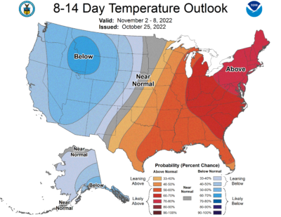
–While the first week of November does look to be on the milder side, there are some signals that have started to pop that could indicate a colder back half of November, but I’ll keep an eye on it and let you know if that signals strengthens
–If it does, we can’t rule out our first snow showers at the very least before we reach December. We shall see…
Have a great day, and if you like my work you can support it by buying one or three (for gifts!) of my 2023 calendars… it’s a great local-color-filled daily companion and this year is replete with tons of cool local storm history!
—2023 CALENDAR SECURE ORDER/INFO LINK
Did you know that you can also follow me on Twitter?
AND REMEMBER…
“Hello babies. Welcome to Earth. It’s hot in the summer and cold in the winter. It’s round and wet and crowded. On the outside, babies, you’ve got a hundred years here. There’s only one rule that I know of, babies: Goddamn it, you’ve got to be kind.”
–Kurt Vonnegut