
__________________________________
2023 WEATHER WALL CALENDAR AVAILABLE TO ORDER
–12 Serene and gorgeous local WMass photos
–Featured article on how the Sun drives Earth’s weather
–Deep-dives into the Top 12 most remarkable regional storms including their impacts, my personal stories, and the under-the-hood meteorology that allowed them to form
–12 weather-themed haiku, and much more!
Good morning to you, we have patchy fog and drizzle this morning, dense fog in some areas, and showers in western CT, the Taconics, and the Berkshires tracking south to north.
After a cloudy and warm / humid day, more showers move in by tomorrow morning into Wednesday. By then, we’ll see a cold front bring drier, sunnier, cooler air in for Thursday afternoon and night, lasting through the weekend, but before we jump into the details, let’s check a note from our local and delicious sponsor, #TandemBagelCo, with their newest location in West Springfield, MA.
——————–
A NOTE FROM OUR SPONSOR:
DHTWN Is Sponsored by Members, Patrons & Tandem Bagel Company: No matter the weather, Tandem Bagel is always there for you at several valley locations to make your mornings brighter! With bagels baked fresh daily (including Gluten-Free options), house-whipped cream cheese, coffee, and tons of lunch options, Tandem is the perfect quick stop for lunch, breakfast, or a coffee and bagel to go. Find them in Easthampton, Northampton, Hadley, Florence, and West Springfield, or use their super-streamlined online ordering tool by visiting their website.
——————————————-
***DHTWN DAILY WEATHER REPORT***
——————————————-
NWS ALERTS
–Dense Fog Advisory for southern Worcester County until 9am.
DHTWN REMINDER
–The odds of being a human is 1 in 400,000 billion… make it count, even in a small way (see Kurt Vonnegut quote at end of post)
DAILY CELESTIAL (STAR):
–OUR STAR ROSE AT: 7:14am this morning
–OUR STAR WILL SET AT: 5:53pm this evening
–TOTAL DAYLIGHT TIME: 10 hours and 39 minutes
DAILY CELESTIAL (MOON):
–OUR MOON WILL SET AT: 6:05pm this afternoon
–OUR MOON WILL RISE AT: 8:33am tomorrow morning
–MOON SET DIRECTION: West-Southwest
–MOON RISE DIRECTION: East-Southeast
–MOON PHASE: New Moon / Waxing Crescent (0.1%)
———————-
DAILY TERRESTRIAL (ZoneCast)
ZONE 1 (Northern Region)
Southern VT, Southwest NH, N. Taconics NY
–High Temps: Mid 60s to Low 70s
–Low Temps: Mid to Upper 50s
–Wind: Light southeasterly
–Skies: Mostly Cloudy
–Precipitation: A few morning SVT showers, patchy drizzle/fog, isolated showers here and there, mostly rain-free until late tonight
ZONE 2 (Central Region)
WMass, N. CMass, N. Litchfield County, C./S. Taconics NY
–High Temps: Mid 60s to Low 70s
–Low Temps: Mid to Upper 50s
–Wind: Light southeasterly
–Skies: Mostly Cloudy
–Precipitation: Early morning showers mostly west of the I-91 corridor move through by mid-morning. Otherwise, patchy drizzle/fog, isolated showers here and there, mostly rain-free until late tonight when more showers move into the region
ZONE 3 (Southern Region)
S. CMass, S. Litchfield County, NC.CT, & NE.CT
–High Temps: Mid 60s to Low 70s
–Low Temps: Upper 50s to Low 60s
–Wind: Light southeasterly
–Skies: Mostly Cloudy
–Precipitation: Early morning showers mostly west of the I-91 corridor move through by mid-morning. Otherwise, patchy drizzle/fog, isolated showers here and there, mostly rain-free until late tonight when more showers move into the region
———————-
WEATHER REPORT
Good morning folks, remember to consider raising your ‘brows in the face of problems today. It’s a good response, because if you’re going to deal with problems, it’s nice to lift the eyebrows which is a facial position of openness to solutions, vs. the furrowed brow of seriousness and gravity.
Life is always going to have problems in it, so (and this is all a BIG note to self, by the way!) might as well try to mix in some levity when possible to the effort of moving forward in the face of whatever unpleasant thing may show up today.
Anyway, now here’s Dave with the Double–Dash–Delivery of the Weather!
NON-SUMMERY SUMMARY
–Well, actually, it IS a touch summery today and tomorrow!
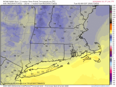
–A warm front moves through from the southeast to northwest and should bring our temps into the mid 60s to low 70s today/Tuesday with dewpoints rising into the low 60s later today and tomorrow
–We may even see some mid 60s dewpoints briefly on Wednesday, which is quite humid for late October!
–We have early morning showers underway in western CT, the Berkshires, Taconics, and SVT, and those should abate by mid morning or so
–Patchy fog and drizzle will also take until about mid to maybe later morning to also evaporate out, and it is dense in places like Worcester, so take it easy driving
–By afternoon, just an isolated shower here and there will be possible, otherwise we’re mostly cloudy and dry on this Tuesday
–Tonight, lows drop to the 55-60º range and more showers work back into the region thanks to a system north of Bermuda that will make a swipe at southern New England, delivering its brunt to EMass, southeast NH, and Maine through Wednesday
–Still, Wednesday will be showery at times, with heavy rain in spots, and highs will reach the mid to upper 60s with dewpoints in the 60s and cloudy skies
–Showers will taper off sometime on Wednesday night with lows in the low 50s as a cold front approaches the region, draped off of a low center that will bring early-season snows to western Quebec
–On Thursday, our front moves through the region with highs cresting into the mid 60s but then falling back later in the afternoon with northwest gusts to 25mph and lows at night dropping into the mid 30s
–Friday through Sunday looks mostly sunny, autumnal and lovely with highs in the mid to upper 50s with frosty lows in the low to mid 30s
–By early next week, likely by Tuesday morning, another storm should bring some more rain showers to the region, but no big storms or cool-downs are in sight as we move into very early November
Have a great day, and if you like my work you can support it by buying one or three (for gifts!) of my 2023 calendars… it’s a great local-color-filled daily companion and this year is replete with tons of cool local storm history!
2023 WEATHER WALL CALENDAR AVAILABLE TO ORDER
Did you know that you can also follow me on Twitter?
AND REMEMBER…
“Hello babies. Welcome to Earth. It’s hot in the summer and cold in the winter. It’s round and wet and crowded. On the outside, babies, you’ve got a hundred years here. There’s only one rule that I know of, babies: Goddamn it, you’ve got to be kind.”
–Kurt Vonnegut