
Good morning everybody, we’re dealing with dry but breezy conditions today with wind gusts already up to 25mph, but rain will be shunted to south.
We’ve got a partly sunny stretch into mid-week as Ian’s remnant clouds meander to our south and filter in at times, and while we’re start off cool, we’ll finish quite mild by late week before a sharper cool down by next weekend, but before we dive into all of the weather details below, let’s check a note from our local weekend sponsor, #YankeeMattressFactory, with their main headquarters in Agawam, MA along with stores located around the valley.
——————–
A NOTE FROM OUR WEEKEND SPONSOR:
DHTWN is sponsored by members, patrons, and Yankee Mattress Factory. Yankee Mattress is employee-owned, and mattresses are handmade locally in Agawam, MA. Several years ago I purchased a Yankee mattress and was very pleased with their quality and the buying experience, which was friendly and low pressure. Starting on September 1st and running through October 31st, Yankee Mattress will be partnering with the American Cancer Society to raise money to support breast cancer research and local services. A portion of each mattress sale will go towards their goal of donating $10,000 towards this cause. Visit the Yankee Mattress store closest to you in Agawam, Springfield, Northampton, or Greenfield, or click for more info.
——————————————-
***DHTWN DAILY WEATHER REPORT***
——————————————-
Good morning, everybody, I’m going to detail our weather details below, but before we do a double–dashed detailed dive into today’s weather story… a brief reminder that your orders of my 9th annual Weather Wall Calendar help me to continue to focus on publishing this interactive local weather resource daily.
I’m confident that you’ll enjoy this year’s filled-to-the-brim edition with great Local and Historical storm info, weather education, gorgeous regional photos, and so much more, so please visit my website for more details or to order at the above link.
Thank you!
WEATHER REPORT
–Good morning folks, with temps starting out in the 40s and 50s, we’ll see highs climb only into the mid 50s to low 60s
–Skies should be mostly cloudy the further south you go, with partly sunny skies more north of the Pike today
–The remnants of Hurricane Ian are situated south and southwest of us in the form of clouds, and leftover areas of rain, as the wind in that system has mostly dissipated
–Any showers along the south coast should likely stay near southern CT/RI, if they even get that far north
–High pressure continues to press south into New England tonight, which should weaken the gradient and cause winds to slacken a bit
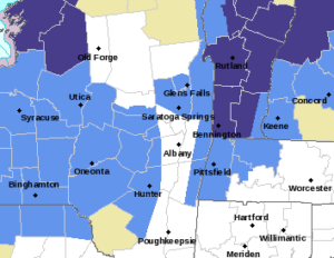
–We usually like to see clear skies, calm winds, and dry conditions for maximizing frost, but the clouds should be high/thinner, and the wind is expected to sit down early enough to allow temps to drive into the low to mid 30s in much of SVT
–In addition, northwest MA and southwest NH should see lows in the mid to upper 30s, so Freeze Warnings are up for SVT and Frost Advisories for the Berkshires/Taconics, Franklin County, western Hampshire County, and southwest NH west into the Brattleboro region
–Lows in the southern valley into northern CT should be more toward the upper 30s to 40º
–Monday and Tuesday should feature the last effects of Ian which will just be some partly sunny skies mixed with clouds, and highs in the upper 50s to low 60s
–Lows will be in the 30s Monday night with more patchy frost possible by early Tuesday morning, and lows in the 40s Tuesday night
–We’ll finally get Ian’s remnants out of here by mid week as high pressure builds to our south for a couple of days
–This will produce mostly sunny skies, and highs in the mid to upper 60s Wednesday, and the low 70s by Thursday!
–Thereafter, we should see a strong cold front careen through the region sometime on Friday, which will bring likely the coldest air of the new Autumn season into our region, with highs only in the 40s and 50s by Saturday
–I’ve even seen some model guidance printing out snow for southern VT and far northwest MA!
–Stay tuned for updates, but for now, after our breezy Sunday, it’s fairly pedestrian weather for next week before we turn colder, at least briefly next weekend
Have a great day, and please check out my 2023 calendar, it’s a great local daily companion, and is great for holiday gifts too!
Remember that you can also follow me on Twitter.
AND REMEMBER…
“Hello babies. Welcome to Earth. It’s hot in the summer and cold in the winter. It’s round and wet and crowded. On the outside, babies, you’ve got a hundred years here. There’s only one rule that I know of, babies: Goddamn it, you’ve got to be kind.”
–Kurt Vonnegut