
__________________________________
2023 CALENDAR SECURE ORDER/INFO LINK
–Serene and gorgeous local WMass photos
–Deep-dives into the Top 12 most remarkable regional storm histories, personal stories, and the under-the-hood meteorology that created them
–12 weather-themed haiku
–Featured article on how the Sun drives Earth’s weather, and so much more!
Good morning folks, we have a cold morning out there with frost in spots, and freezing fog possible in others (this could cause some slippery travel), but the main weather story is breezy but fair/cool conditions today and tomorrow with more warming with sunshine for Friday into Sunday to be followed by inclement weather Sunday night into early next week, but before we jump into the details, let’s check a note from our local and delicious sponsor, #TandemBagelCo, with their newest location in West Springfield, MA.
——————–
A NOTE FROM OUR SPONSOR:
DHTWN Is Sponsored by Members, Patrons & Tandem Bagel Company: No matter the weather, Tandem Bagel is always there for you at several valley locations to make your mornings brighter! With bagels baked fresh daily (including Gluten-Free options), house-whipped cream cheese, coffee, and tons of lunch options, Tandem is the perfect quick stop for lunch, breakfast, or a coffee and bagel to go. Find them in Easthampton, Northampton, Hadley, Florence, and West Springfield, or use their super-streamlined online ordering tool by visiting their website.
——————————————-
***DHTWN DAILY WEATHER REPORT***
——————————————-
NWS ALERTS
–None, but Freezing Fog is possible at Orange, MA with dense fog reported and temp of 30º. Eastern Franklin County north into Cheshire County NH should be alert to road conditions where fog is present.
DHTWN REMINDER
–The odds of being a human is 1 in 400,000 billion… make it count, even in a small way (see Kurt Vonnegut quote at end of post)
DAILY CELESTIAL (STAR):
–OUR STAR ROSE AT: 7:07am this morning
–OUR STAR WILL SET AT: 6:02pm this evening
–TOTAL DAYLIGHT TIME: 10 hours and 55 minutes
DAILY CELESTIAL (MOON):
–OUR MOON WILL SET AT: 3:47pm this afternoon
–OUR MOON WILL RISE AT: 1:41am tomorrow morning
–MOON SET DIRECTION: West-Northwest
–MOON RISE DIRECTION: East-Northeast
–MOON PHASE: Waning Crescent (33.9%)
———————-
DAILY TERRESTRIAL (ZoneCast)
ZONE 1 (Northern Region)
Southern VT, Southwest NH, N. Taconics NY
–High Temps: Low to Mid 50s
–Low Temps: Upper 20s to Low 30s
–Wind: Southwest gusts 10-20mph
–Skies: Patchy fog early, then mostly sunny
–Precipitation: None
ZONE 2 (Central Region)
WMass, N. CMass, N. Litchfield County, C./S. Taconics NY
–High Temps: Low to Mid 50s
–Low Temps: Low to Mid 30s
–Wind: Southwest gusts 10-20mph
–Skies: Patchy fog early, then mostly sunny
–Precipitation: None
ZONE 3 (Southern Region)
S. CMass, S. Litchfield County, NC.CT, & NE.CT
–High Temps: Low to Mid 50s
–Low Temps: Mid to Upper 30s
–Wind: Southwest gusts 10-20mph
–Skies: Patchy fog early, then mostly sunny
–Precipitation: None
———————-
WEATHER REPORT
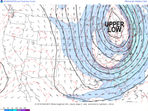
Good morning everybody, there isn’t a ton to talk about this morning other than we have a huge upper low gyre that has been cutoff from the larger steering flow in the Troposphere, and has pulled cool air from Canada south all the way to the southeast U.S. and up into New England – our cooler air is coming from the southwest, which is quite unusual!
Also, I am concerned for the potential of freezing fog early this morning in parts of the region, notably eastern Franklin County and southwest NH where temps are below freezing with dense fog noted at Orange, MA (visibility of a quarter mile).
After temps come up and fog lifts, we’ll enjoy a sunny but cool day with highs only in the upper 40s to mid 50s and with southwest winds gusting to 20mph at times.
If winds stay up a bit tonight as expected, we should see less in the way of upper 20s lows as we saw for some this morning, and hang more in the low to mid 30s. However, frost is still possible with dry conditions and under clear skies.
Also, watch for patchy fog again tomorrow morning, and whenever fog is present and temps are at freezing or below, be aware of road conditions and surfaces because ice glaze could form.
On Thursday, high pressure continues to nudge in from the southwest under the southern flank of the departing upper level cutoff low lifting northeast into Canada.
Sunshine is expected with highs again in the low to mid 50s, and with lows in the low to mid 30s and gusty southwest winds up to 20mph at times.
For Friday, we get sunshine again as high pressure starts to push deeply into and south of our region. Highs will reach the upper 50s to low 60s with lows in the mid to upper 30s.,
The weekend looks mostly sweet and dry, with Saturday being the pick in terms of volume of sunshine on the epidermal areas! Highs will be well into the 60s and approaching 70º Saturday with lows in the low to mid 40s, with more partly sunny skies on Sunday with highs in the mid to upper 60s as clouds build late.
At night, we’ll have to watch for a coastal system that may track due north enough of to put the greater WMass region into an area of rain showers that could last into Monday or so.
We’ll get a break of fair weather by Tuesday or Wednesday, but another frontal system could push more showers into our region by next Thursday.
High temps generally hang in the 60s from Sunday through middle of next week with lows in the low to mid 40s through this period.
Have a great day, and if you like my work you can support it by buying one or three of my 2023 calendars… it’s a great local-color-filled daily companion, this year with tons of cool local storm history, and it’s great for holiday gifts too!
2023 CALENDAR SECURE ORDER/INFO LINK
Did you know that you can also follow me on Twitter?
AND REMEMBER…
“Hello babies. Welcome to Earth. It’s hot in the summer and cold in the winter. It’s round and wet and crowded. On the outside, babies, you’ve got a hundred years here. There’s only one rule that I know of, babies: Goddamn it, you’ve got to be kind.”
–Kurt Vonnegut