[7:06AM FRI 10/18/24] ONE FINAL CHANCE FOR PATCHY FROST LATE TONIGHT IS FOLLOWED BY INCREASING SUNSHINE, DECREASING WIND, AND INCREASING WARMTH THROUGH THE GREATER WMASS REGION STARTING TODAY AND LASTING INTO THE MIDDLE OF NEXT WEEK… NEXT CHANCE OF RAINFALL IS WEDNESDAY NIGHT INTO THURSDAY… LIKE TO SUPPORT LOCAL?

~ Colorful Regional Photos & Educational Content
~ Affordable, Useful, & Practical
~ WMass Community-Oriented & Contemplative
~ Great for holiday gifts (click to securely order)
~~~~~~~~~~~~~~~~~~~~~~
TABLE OF CONTENTS
* Daily Celestials (Sun/Moon Data)
* Sponsor Note
* DHTWN Announcements
* Morning Discussion
* TIP: Scroll below for sections, or read all
~~~~~~~~~~~~~~~~~~~~~~
YOUR DAILY CELESTIALS
~~~~~~~~~~~~~~~~~~~~~~
STAR:
–OUR STAR ROSE AT: 7:07am this morning
–OUR STAR WILL SET AT: 6:03pm this evening
–TOTAL DAYLIGHT TIME: 10 hours and 56 minutes
MOON:
–OUR MOON WILL SET AT: 8:34am today
–MOON SET DIRECTION: West-Northwest
–OUR MOON WILL RISE AT: 6:35pm today
–MOON RISE DIRECTION: East-Northeast
–MOON PHASE: Waning Gibbous (98.5%)
~~~~~~~~~~~~~~~~~~~~~~
A NOTE FROM OUR SPONSOR
~~~~~~~~~~~~~~~~~~~~~~
Dave Hayes The Weather Nut is Sponsored by Individual Community Members, Patrons, and Tandem Bagel Company… No matter the weather, Tandem Bagel is always there for you at several valley locations to make your mornings brighter! With *New Pizza Bagels(!)*, along with bagels baked fresh daily (including Gluten-Free options), house-whipped cream cheese, coffee, and tons of lunch options, Tandem is the perfect quick stop for lunch, breakfast, or a coffee and bagel to go.
You can either 1) visit them in Easthampton, Northampton, Hadley, Florence, and/or West Springfield, 2) hire them to cater your next event, or 3) use their super-streamlined online ordering tool by visiting their website and clicking the “Catering” or “Order Online” links.
~~~~~~~~~~~~~~~~~~~~~~
DHTWN ANNOUNCEMENTS
~~~~~~~~~~~~~~~~~~~~~~
(Available to Order via Cards, Venmo, PayPal, or Check)
~~~~~~~~~~~~~~~~~~~~~~
YOUR MORNING DISCUSSION
~~~~~~~~~~~~~~~~~~~~~~
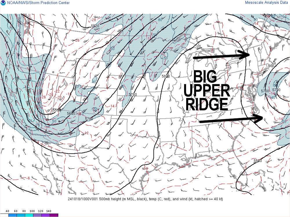
Good morning folks, yet another chilly start is greeting us this morning with temps in the upper 20s through thee 30s, but temps will rebound today as a large upper ridge is pressing east and shoving the old upper trough responsible for this cold and a nearby coastal low out to sea.
This will open the doors for even more sunshine, and more importantly a warmer flow to develop into southern New England over the next 6 days.
For today, the last of a northerly wind will perhaps gust to 15mph at times, but otherwise we will start shifting our wind around from the north to calm to more of a west and southwest wind later this weekend, which will start to develop warmer temps into our region into the middle of next week.
Highs today will reach the low to mid 60s with lows in the low to mid 30s for one last night of patchy frost before temps lift away from those levels through at least next Wednesday night.
Highs over the weekend will climb into the mid 60s to low 70s, warmest on Sunday, sunshine though out with clear skies at night.
Monday through Wednesday is when southwest warming flow maximizes through the greater WMass region with highs in the upper 60s to mid 70s and lows in the 45-50º range.
Thereafter a stronger-looking cold front should sweep the region Wednesday night into Thursday with a period of showers, which represents our next chance for rainfall.
Have a great day, and please remember me for your holiday gift shopping, or if you need a calendar (order link below):
(Securely Order via Cards, Venmo, PayPal, Check)
“Follow your bliss and the universe will open doors for you where there were only walls.”
― Joseph Campbell
