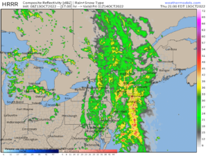
[5:10PM ALERT] FLOOD WATCHES HAVE BEEN HOISTED FOR THE ENTIRE GREATER WMASS REGION… WIND ADVISORIES HAVE BEEN HOISTED FOR THE NORTHERN BERKSHIRES AND SOUTHERN VT… Good evening everybody, heavier rain is gathering over eastern NY as well as eastern NJ and to coast-adjacent ocean areas south of Long Island as the cold front presses east and the energy behind it slowly pivots its axis into a more south to north orientation, which is the direction of our overall flow tonight.
This should combine to develop heavy rain showers at times overnight, and as the cold front moves through during the pre-dawn hours, southeast winds may peak out between 25-40mph, and possibly a little higher just after midnight in the northern Berkshires and southern VT where the Wind Advisories have been hoisted.
Flood Watches are up region wide for a combination of either street flooding partially due to leaf-clogged drains, or small stream flood with the potential for an isolated flash flood warning in any downpours or t-storms that may train over one area.
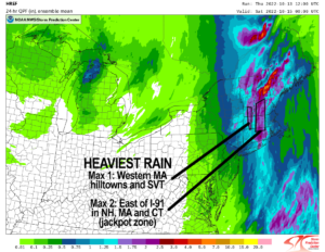
Heaviest rain totals in southern New England likely end up east of the I-91 corridor in northeast CT, CMass, and possibly eastern parts of Cheshire County NH and even easternmost areas of the 3 Pioneer Valley counties in WMass.
Another max area of rainfall would normally be due to southeast winds interacting with the western hilltowns of Hampshire and Franklin Counties up into the southern Greens of VT.
Please post any reports below this post, but I will keep an eye on things and hop back on here if anything looks newsworthy.
Enjoy your evening… and how about that humidity!
——–

Possible radar depiction this evening, with heavy rain
2023 WEATHER WALL CALENDAR AVAILABLE TO ORDER:
–Serene and gorgeous local photos
–Deep-drive into the Top 12 most remarkable/impactful regional storm histories, personalstories, and the under-the-hood meteorology that created them
–My weather-themed haiku
–Featured article on how the Sun drives Earth’s weather, and much more!
SECURE 2023 CALENDAR ORDER/INFO LINK
Good morning folks, we’ve entered a new pattern with several opportunities for Great Lakes cutoff low pressure systems to send waves and fronts our way, and we’ve got one moving through tonight with wind and rain.
A few of us will see a few isolated or scattered showers either this morning or afternoon with the main brunt of rainfall moving in around sunset and lasting overnight into early Friday morning with southeasterly wind gusts and heavy rain at times, followed by a lovely and mild weekend with even more chances for rain early to middle of next week, but before we jump into the details, let’s check a note from our local and delicious sponsor, #TandemBagelCo, with their newest location in West Springfield, MA.
——————–
A NOTE FROM OUR SPONSOR:
DHTWN Is Sponsored by Members, Patrons & Tandem Bagel Company: No matter the weather, Tandem Bagel is always there for you at several valley locations to make your mornings brighter! With bagels baked fresh daily, house-whipped cream cheese, coffee, and tons of lunch options, Tandem is the perfect quick stop for lunch, breakfast, or a coffee and bagel to go. Find them in Easthampton, Northampton, Hadley, Florence, and West Springfield, or use their super-streamlined online ordering tool by visiting their website.
——————————————-
***DHTWN DAILY WEATHER REPORT***
——————————————-
NWS ALERTS
–None
DHTWN REMINDER
–The odds of being a human is 1 in 400,000 billion… make it count, even in a small way (see Kurt Vonnegut quote at end of post)
DAILY CELESTIAL (STAR):
–OUR STAR ROSE AT: 7:00am this morning
–OUR STAR WILL SET AT: 6:11pm this evening
–TOTAL DAYLIGHT TIME: 11 hours and 11 minutes
DAILY CELESTIAL (MOON):
–OUR MOON WILL RISE AT: 8:16pm this evening
–OUR MOON WILL SET AT: 12:07pm tomorrow morning
–MOON RISE DIRECTION: Northeast
–MOON SET DIRECTION: Northwest
–MOON PHASE: Waning Gibbous (86.9%)
———————-
DAILY TERRESTRIAL (ZoneCast)
ZONE 1 (Northern Region)
Southern VT, Southwest NH, N. Taconics NY
–High Temps: Upper 60s to Low 70s
–Low Temps: Low to Mid 50s
–Humidity: Dewpoints into the low 60s, humid
–Wind: Southeast winds may gust 25-35mph by afternoon/evening
–Skies: Mostly Cloudy becoming Overcast
–Precipitation: A few showers possible this morning and through mid afternoon, then rain heavy at times tonight into very early Friday morning, some street flooding possible, be sure to keep drains cleared of leaves to reduce clogs and roadway ponding
ZONE 2 (Central Region)
WMass, N. CMass, N. Litchfield County, C./S. Taconics NY
–High Temps: Upper 60s to Low 70s
–Low Temps: Low to Upper 50s
–Humidity: Dewpoints into the low 60s, humid
–Wind: Southeast winds may gust 25-35mph by afternoon/evening
–Skies: Mostly Cloudy becoming Overcast
–Precipitation: A few showers possible this morning and through mid afternoon, then rain heavy at times tonight into very early Friday morning, some street flooding possible, be sure to keep drains cleared of leaves to reduce clogs and roadway ponding
ZONE 3 (Southern Region)
S. CMass, S. Litchfield County, NC.CT, & NE.CT
–High Temps: Upper 60s to Low 70s
–Low Temps: Mid to Upper 50s
–Humidity: Dewpoints into the low 60s, humid
–Wind: Southeast winds may gust 25-35mph by afternoon/evening
–Skies: Mostly Cloudy becoming Overcast
–Precipitation: A few showers possible this morning and through mid afternoon, then rain heavy at times tonight into very early Friday morning, some street flooding possible, be sure to keep drains cleared of leaves to reduce clogs and roadway ponding
———————-
WEATHER REPORT
Good morning everybody, I hope you slept well and woke up with the strength, vim and vigor to get up and out in the world, impress your will up on it, and make things happen today. All I ask is that you pack some rain gear with you, especially if you’re heading out for dinner this evening!
For now, we have a pair of cold fronts to our west with strong upper level energy digging in behind them and pushing these boundaries our way.
Meanwhile, a strong southerly flow is developing that will siphon moisture from south to north into our region this afternoon and especially tonight and into early Friday morning.
It will be mild with that southerly flow today, as highs should rise up to either side of 70º, and we could see a few spotty showers this morning or into the mid afternoon, and one or two may be on the heavier side.
However, shower activity should be on the lighter, more isolated until we get toward the later afternoon and early evening when swaths of heavier rainfall will be slowly pushing east into the region, as it tracks generally south to north.
Lows will hang in the 50s, and south to southeast winds will gust 25-35mph later afternoon and tonight. Some rumbles of thunder are possible, as well as street flooding in spots due to leaves clogging drains.
A NOTE ON LEAF-COVERED ROADS
I knew a young man back in college that was in a car that was driving up the S-curve in Shutesbury, MA on a night just like tonight should/could be, and the roads were covered with leaves. For whatever reason, they suddenly had to brake, got in an accident, and he became paralyzed. I’m not trying to be a doom and gloomer or overly dramatic, but I bring it up to say that when ever you come across leaf covered roadways on a wet road, proceed with some caution as slippery travel can develop fast.
By tomorrow morning, a general 1-3″ of rain is expected, with a few lighter amounts possible, and showers could still be moving through the region, especially along and east of the I-91 corridor.
Sunshine should develop from west to east, earlier west, later east, especially as we get to the mid-day hours. Highs will climb intro the 60s, and lows will drop into the upper 30s to low 40s under mostly clear skies.
High pressure builds in over the weekend with a light southerly flow continuing based on the position of low pressure near the Great Lakes and the counterclockwise circulation around it.
Saturday highs will reach the mid to upper 60s (pick of the weekend) and Sunday highs in the low to mid 60s under mostly sunny skies with lows in the 40s.
Clouds may build Sunday night with a few showers, and another set of frontal boundaries and low pressure will bring more periods of showers early next week.
By Tuesday, temps should be coming down as well and we may get a lake-effect pattern setting up by evening. Highs will only be in the 50s, with lows in the 30s, and highs Wednesday only rising into the upper 40s to low 50s.
Still think we could see some first snowflakes in southern VT or the Berkshires Tuesday night into Wednesday morning, but I will keep you updated
Have a great day, and please check out my 2023 calendar, it’s a great local-color-filled daily companion, you’ll learn a bunch of cool local weather history, and it’s great for holiday gifts too!
SECURE 2023 CALENDAR ORDER/INFO LINK
Did you know that you can also follow me on Twitter?
AND REMEMBER…
“Hello babies. Welcome to Earth. It’s hot in the summer and cold in the winter. It’s round and wet and crowded. On the outside, babies, you’ve got a hundred years here. There’s only one rule that I know of, babies: Goddamn it, you’ve got to be kind.”
–Kurt Vonnegut
