TABLE OF CONTENTS
* Celestials (Sun/Moon Info)
* Weekly Nutshell
* Morning Discussion
* Scroll below for your sections, or read all
~~~~~~~~~~~~~~~~~~~~~~
YOUR DAILY CELESTIALS
~~~~~~~~~~~~~~~~~~~~~~
STAR:
–OUR STAR ROSE AT: 6:58am this morning
–OUR STAR WILL SET AT: 6:15pm this evening
–TOTAL DAYLIGHT TIME: 11 hours and 17 minutes
MOON:
–OUR MOON WILL SET AT: 5:14pm this afternoon
–MOON SET DIRECTION: West
–OUR MOON WILL RISE AT: 4:43am tomorrow morning
–MOON RISE DIRECTION: East
–MOON PHASE: Waning Crescent (10.0%)
~~~~~~~~~~~~~~~~~~~~~~
YOUR WEEKLY WEATHER NUTSHELL
~~~~~~~~~~~~~~~~~~~~~~
–Some isolated light showers this morning gives way to a more-clouds-than-sun day
–Highs upper 50s to mid 60s, light west-southwest wind
–Could see a few more showers later, nothing major
–Lows in the low 40s, partly cloudy
–Thursday could start with some patchy fog, highs low to mid 60s, partly sunny skies, a spot shower possible, lows near 40º
–Friday is cooler, highs 55-60º as low pressure locates northeast of us, driving northwest flow into the region
–Mostly sunny skies expected, a nice Fall day!
–Lows fall into the low to mid 40s as clouds increase ahead of our weekend storm system
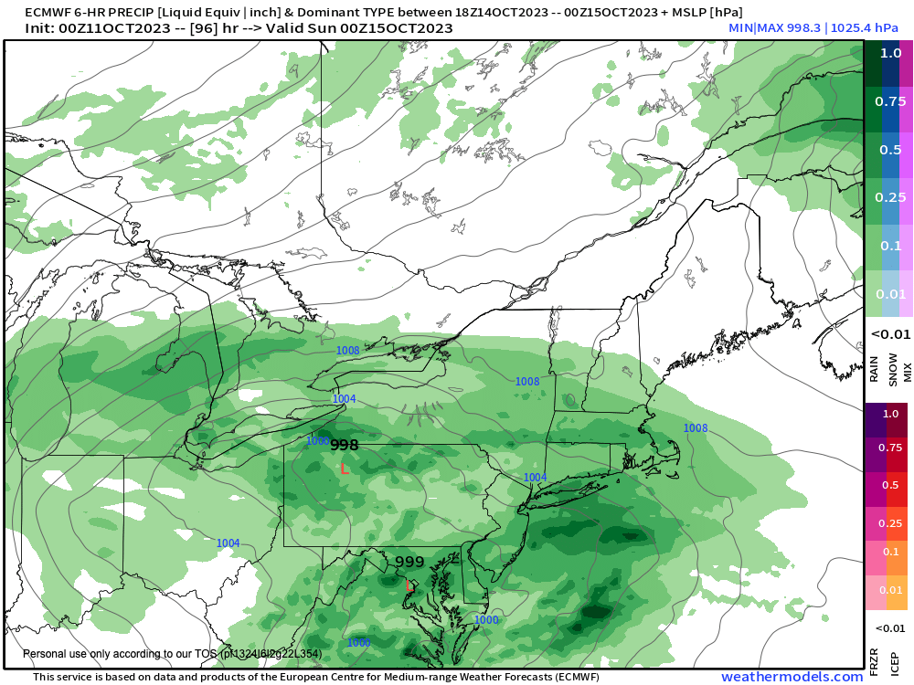
–For now Saturday morning looks dry, with best chance of rain occurring late afternoon and especially at night into Sunday morning
–Storm track and storm impacts will come down to Hudson Bay high pressure and an Atlantic Canadian low to see how far south they suppress our storm
–Highs will only be in the 50s over the weekend, which looks mostly cloudy, with lows in the 40s
–An upper low behind this surface coastal low could produce scattered instability showers with glimpses of sunshine early next week with highs only in the 50s with breezy conditions, but before we talk details let’s check a note from our local and delicious sponsor, #TandemBagelCo, with their newest location in the Stop & Shop Plaza on King Street in Northampton, MA.
~~~~~~~~~~~~~~~~~~~~~~
A NOTE FROM OUR SPONSOR
~~~~~~~~~~~~~~~~~~~~~~
Dave Hayes The Weather Nut is Sponsored by Individual Community Members, Patrons, and Tandem Bagel Company… No matter the weather, Tandem Bagel is always there for you at several valley locations to make your mornings brighter! With bagels baked fresh daily (including Gluten-Free options), house-whipped cream cheese, coffee, and tons of lunch options, Tandem is the perfect quick stop for lunch, breakfast, or a coffee and bagel to go. Find them in Easthampton, Northampton, Hadley, Florence, and West Springfield, or use their super-streamlined online ordering tool by visiting their website.
~~~~~~~~~~~~~~~~~~~~~~
YOUR MORNING DISCUSSION
~~~~~~~~~~~~~~~~~~~~~~
Good morning everybody, we’re starting off mostly cloudy this morning as a weak wave works through the region and brings a few generally lighter showers scattered about.
This wave moves through and then a few sunny breaks or periods are possible with additional cloudiness and a spot shower possible by afternoon, with highs in the upper 50s to mid 60s.
For tonight, we should be drying out with lows in the low 40s, and some patchy fog may develop in a few spots.
Thursday looks mostly dry, but again a few isolated showers can’t be ruled out under partly sunny skies with highs in the low to mid 60s and a light west wind.
Lows will drop to either side of 40º as our no-big-whoop weather wonderment continues while our lazy lollygagging upper low located in the eastern Great Lakes sweeps east toward Atlantic Canada by Friday.
On Friday, expect cooler temps thanks to said low’s position driving northwest flow into the greater WMass region which will provide high temps only in the 55-60º range.
It will be mostly sunny during the day, but clouds will increase at night with lows in the low 40s.
By Saturday, we can expect a mostly cloudy day, and how much rain impacts will be seen across our region will have much to do with how much dry air that Atlantic Canadian upper low drives south and into our region, aided by strong Hudson Bay high pressure which will essentially providing and strengthening that same drying flow.
Meanwhile, our storm system will have tracked east across the country and through the Ohio Valley to the Mid-Atlantic coast.
WHERE exactly on the coast the storm exits is TBD, and could end up being suppressed more toward Delaware than northern Jersey, which would pull rain impacts south of the Route 2 corridor, and possibly even south of the Pike.
The main rain timeframe would be Saturday later afternoon, night and into the first part of Sunday before the storm departs, but PLEASE check back with me for updates on this storm potential.
Highs will only be in the 50s this weekend, with lows in the 40s. By early next week the upper low trailing the coastal storm looks to keep temps cool and in the 50s for highs, but also should keep at least some clouds around if not a chance for periods of scattered instability showers at times as well.
I hope you have a great day and that you are able to have a good laugh at least once today, and if not, you can at least choose to think about an event in your past that made you feel happy and smile and raise your eyebrows as you think of it and relive it in your imagination. :-)
>>> BE KIND <<<
“Hello babies. Welcome to Earth. It’s hot in the summer and cold in the winter. It’s round and wet and crowded. On the outside, babies, you’ve got a hundred years here. There’s only one rule that I know of, babies: Goddamn it, you’ve got to be kind.”
–Kurt Vonnegut
