
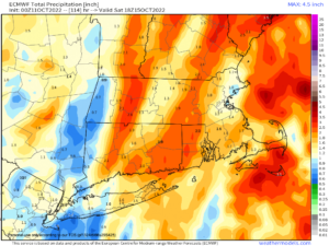
Good signal for 1-2″ of rainfall overnight Thursday, with gusty winds 25-40mph out of the SE overnight
2023 WEATHER WALL CALENDAR AVAILABLE TO ORDER:
–Serene and gorgeous local photos
–Deep-drive regional storm histories, stories, and the meteorology involved
–Weather-themed haiku
–Featured article on how the Sun drives Earth’s weather, and much more!
SECURE 2023 WEATHER CALENDAR ORDER/INFO LINK
Good morning folks, after patchy dense fog burns off we’ve got a pair of lovely Fall days ahead followed by dynamic, rainy and windy frontal passage Thursday afternoon and overnight with clearing by noon on Friday and followed by a lovely weekend ahead, but before we jump into the details, let’s check a note from our local and delicious sponsor, #TandemBagelCo, with their newest location in West Springfield, MA.
——————–
A NOTE FROM OUR SPONSOR:
DHTWN Is Sponsored by Members, Patrons & Tandem Bagel Company: No matter the weather, Tandem Bagel is always there for you at several valley locations to make your mornings brighter! With bagels baked fresh daily, house-whipped cream cheese, coffee, and tons of lunch options, Tandem is the perfect quick stop for lunch, breakfast, or a coffee and bagel to go. Find them in Easthampton, Northampton, Hadley, Florence, and West Springfield, or use their super-streamlined online ordering tool by visiting their website.
——————————————-
***DHTWN DAILY WEATHER REPORT***
——————————————-
NWS ALERTS
–Frost Advisories in SVT and northern Berkshires expire this morning.
DHTWN REMINDER
–The odds of being a human is 1 in 400,000 billion… make it count, even in a small way (see Kurt Vonnegut quote at end of post)
DAILY CELESTIAL (STAR):
–OUR STAR ROSE AT: 6:58am this morning
–OUR STAR WILL SET AT: 6:15pm this evening
–TOTAL DAYLIGHT TIME: 11 hours and 17 minutes
DAILY CELESTIAL (MOON):
–OUR MOON WILL RISE AT: 7:15pm this evening
–OUR MOON WILL SET AT: 9:55am tomorrow morning
–MOON RISE DIRECTION: East-Northeast
–MOON SET DIRECTION: West-Northwest
–MOON PHASE: Waning Gibbous (97.2%)
———————-
DAILY TERRESTRIAL (ZoneCast)
ZONE 1 (Northern Region)
Southern VT, Southwest NH, N. Taconics NY
–High Temps: Low to Mid 60s
–Low Temps: Low to Mid 40s
–Humidity: Comfortable
–Wind: Light westerly
–Skies: Patchy fog early, then Mostly Sunny
–Precipitation: None
DAILY TERRESTRIAL (ZoneCast)
ZONE 2 (Central Region)
WMass, N. CMass, N. Litchfield County, C./S. Taconics NY
–High Temps: Low to Mid 60s, some upper 60s southern areas
–Low Temps: Low to Mid 40s
–Humidity: Comfortable
–Wind: Light westerly
–Skies: Patchy fog early, then Mostly Sunny
–Precipitation: None
DAILY TERRESTRIAL (ZoneCast)
ZONE 3 (Southern Region)
S. CMass, S. Litchfield County, NC.CT, & NE.CT
–High Temps: Mid to Upper 60s
–Low Temps: Mid to Upper 40s
–Humidity: Comfortable
–Wind: Light westerly
–Skies: Patchy fog early, then Mostly Sunny
–Precipitation: None
———————-
WEATHER REPORT
Well, well, well, top of the morning to you! We’ve got plenty of patchy dense fog out there this morning, notably in the Berkshires, along the Rt. 2 corridor of northern MA and up in SVT and SWNH (and elsewhere in spots), but that will dissipate as we rotate to face our star on this giant tilt-a-sphere thing we’re respirating all over.
It’s chilly this morning with a number of low 30s readings noted in the central and northern Berkshires, a few areas of Franklin County and southwest NH and mostly in southern VT, with a couple of upper 20s for good measure. #Frosty
For today, we’ll see a massive area of high pressure across the eastern U.S. and centered near the Mid-Atlantic coastline begin to drift east offshore to our south.
This will develop a light southwest flow that begins today and picks up warmer air and delivers it to us Wednesday and Thursday #nowthatswhatwecallservice
Expect a sunny Tuesday with light wind and highs in the low to mid 60s, with a few upper 60s possible in northern CT. Lows will dip into the low to mid 40s for most of us under mostly clear skies, though some patchy fog is possible late.
For Wednesday, the pick of the week! Sunshine, highs in the upper 60s to low 70s, and a light south wind, just gorgeous! Lows dip into the low 50s with clouds increasing.
By Thursday, while we may get some sunny breaks early in the morning depending on actual speed of the incoming cold front, expect a mostly cloudy day, and a few showers will be possible by late morning to early afternoon.
This front looks potent, and will be draped southeastward off of a low center near the Great Lakes that will be winding up and tracking this cold front in an east-northeastward track.
Temps will be mild on Thursday before the cold front sweeps the region overnight, and southeast winds ahead of this system will gust to 30mph by afternoon, with showers increasing towards the evening.
Heavy rain at times is expected Thursday night with gusty winds as well, and we can’t rule out isolated power outages, or some foliage removal if the winds really maximize overnight and gust over 40mph. But, that’s still uncertain, yet possible.
Lows Thursday night during our dynamic rainy and windy cold frontal passage will be near 50º and we could see a few thunderstorms, too.
Rain showers and the front should clear to the east early Friday morning, and sunshine will develop at some point in the morning with highs in the 60s with westerly breezes. Lows will land near 40º.
The weekend looks LOVELY with highs either side of 60º and lows either side of 40º with plenty of sunshine.
More dynamic weather is possible early next week with another strong frontal boundary being signaled, but we’re going to focus on this coming Thursday night to Friday morning period for now.
Have a great day, and please check out my 2023 calendar, it’s a great local-color-filled daily companion, you’ll learn a bunch of cool local weather history, and it’s great for holiday gifts too!
SECURE 2023 WEATHER CALENDAR ORDER/INFO LINK
Did you know that you can also follow me on Twitter?
AND REMEMBER…
“Hello babies. Welcome to Earth. It’s hot in the summer and cold in the winter. It’s round and wet and crowded. On the outside, babies, you’ve got a hundred years here. There’s only one rule that I know of, babies: Goddamn it, you’ve got to be kind.”
–Kurt Vonnegut