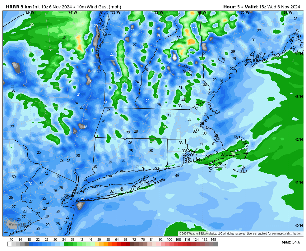
[7:17AM WED 11/6/24] RED FLAG WARNINGS HAVE BEEN HOISTED FOR WESTERN MA, CENTRAL MA, AND NORTHERN CT TODAY… SW WIND GUSTS 20-35MPH WITH WARM AIR AND DRY GROUND CAN EASILY SPREAD GROUND FIRES… RECORD HIGHS LIKELY TODAY… A BIT COOLER LATE WEEK INTO THE WEEKEND WITH FAIR WEATHER… SHOWERS POSSIBLE SUNDAY NIGHT INTO MONDAY… MY 2025 CALENDAR SALE ENDS THIS SUNDAY… NO REPORT TOMORROW…

*** 5 Days Remain to order Dave’s final Calendar, click below***
Dave’s greatest hits edition includes:
~ 12 Lovely Local Photos + Cover
~ Lots of Interesting Weather Lessons
~ 12 of my Best Weather-Themed Haiku
~ Much more including tons of celestial info, WMass storms, Holidays etc.
The 2025 Calendar serves as an affordable and universal Holiday Gift Solution
~~~~~~~~~~~~~~~~~~~~~~
TABLE OF CONTENTS
* Daily Celestials (Sun/Moon Data)
* Sponsor Note
* Morning Discussion
* TIP: Scroll below for sections, or read all
~~~~~~~~~~~~~~~~~~~~~~
YOUR DAILY CELESTIALS
~~~~~~~~~~~~~~~~~~~~~~
STAR:
–OUR STAR ROSE AT: 6:30am this morning
–OUR STAR WILL SET AT: 4:37pm this evening
–TOTAL DAYLIGHT TIME: 10 hours and 7 minutes
MOON:
–OUR MOON WILL RISE AT: 11:40am late this morn
–MOON RISE DIRECTION: Southeast
–OUR MOON WILL SET AT: 8:13pm this eve
–MOON SET DIRECTION: Southwest
–MOON PHASE: Waxing Crescent (22.5%)
~~~~~~~~~~~~~~~~~~~~~~
A NOTE FROM OUR SPONSOR
~~~~~~~~~~~~~~~~~~~~~~
Dave Hayes The Weather Nut is Sponsored by Individual Community Members, Patrons, and Tandem Bagel Company… No matter the weather, Tandem Bagel is always there for you at several valley locations to make your mornings brighter! With *New Pizza Bagels(!)*, along with bagels baked fresh daily (including Gluten-Free options), house-whipped cream cheese, coffee, and tons of lunch options, Tandem is the perfect quick stop for lunch, breakfast, or a coffee and bagel to go.
You can either 1) visit them in Easthampton, Northampton, Hadley, Florence, and/or West Springfield, 2) hire them to cater your next event, or 3) use their super-streamlined online ordering tool by visiting their website and clicking the “Catering” or “Order Online” links.
~~~~~~~~~~~~~~~~~~~~~~
DHTWN ANNOUNCEMENTS
~~~~~~~~~~~~~~~~~~~~~~
2025 Weather Wall Calendar
*Sale Ends This SUNDAY*
(Cards, Venmo, PayPal, Check)
~~~~~~~~~~~~~~~~~~~~~~
YOUR MORNING DISCUSSION
~~~~~~~~~~~~~~~~~~~~~~
Good morning everybody, it’s quite the mild start out there with temps hovering either side of 60º. Given that we have a southwest flow aloft and at the surface with high pressure south of us encouraging this flow, we’re going to see temps soar well into the 70s today with some folks cresting 80º in the southern Pioneer Valley, which could set some records by this evening.
In addition, Red Flag Warnings have been posted by the National Weather Service due to drought conditions and expected southwest winds gusting 20-35mph.
These conditions can take embers from your outdoor burns, campfires or cigarettes and carry them away, start ground fires, and spread those rapidly, putting unnecessary stress on fire crews and resources, and endangering lives of others.
Southwest wind gusts should slacken late this afternoon and into the evening as the low-level jet streak aloft keeps trucking east, but it may still be breezy early in the evening with gusts up to 20mph overnight.
Lows will drop into the low to mid 50s under partly cloudy skies with potential for an isolated shower as a weak cold front comes through.
For Thursday, west to northwest winds will gust up to 20mph or so behind the front and highs will still be well into the 60s under mostly sunny skies, and an elevated risk for fire spread will continue. High pressure will start to press in from the west, and lows will cool down as a result, dipping into the mid to upper 30s under mostly clear skies.
On Friday, more sunshine is expected with temps continuing to gradually cool into the mid 50s to low 60s for highs and 30s for lows.
A dry secondary cold front will bring a reinforcing shot of more seasonably cool air, setting Saturday up for highs in the low to mid 50s under mostly sunny skies, with colder lows in the upper 20s to low 30s.
By Sunday, we’ll be watching a storm that will track ENE out of the Great Lakes and into southern Quebec which will drag a cold front east toward New England. A secondary wave may develop along this front, and while Sunday looks partly sunny with highs in the 50s, clouds will be increasing with time.
This setup may help produce a period of much needed rain showers into our region by Sunday night into Monday, so here’s hoping!
Highs looks to sit on either side of the 60-degree mark into early next week, and there are signs of additional more robust frontal passages which could start laying down some rain every 3 days or so, and at this point, we’ll take what we can get.
Thanks very much for reading, take care, and I hope you’ll choose my final 2025 weather calendar for your holiday gift shopping, or for yourself, as I haven’t had any complaints over 10 years of publishing (sale ends in 5 days, this Sunday)
(Securely Order via Cards, Venmo, PayPal, Check)
“Follow your bliss and the universe will open doors for you where there were only walls.”
― Joseph Campbell
