——————————-
My 2023 Weather Calendar is filled with stunning fan-submitted photos of our beloved region!
Connect with community & click to order today (sale ends 11/20)
——————————-
WEEKLY WEATHER NUTSHELL
Good morning everybody, we have LOTS of weather changes on the way!
We’ll likely see record warmth today, breezy conditions changing from southwest to the north through Tuesday, scattered showers this P.M. and tomorrow morning, fair but much cooler weather by mid week, warming late week, a rainstorm Friday/Saturday, and then even cooler weather a week from today (I’m panting ovah heah!), but before we dive into all of the weather details below, let’s check a note from our new local weekend sponsor, #CranberryHillHealingArts located in Amherst, MA.
——————–
A NOTE FROM OUR WEEKEND SPONSOR:
DHTWN is sponsored by members, patrons, and Cranberry Hill Healing Arts. The turning of the seasons can be challenging, and Carolyn Walker of Cranberry Hill Healing Arts in Amherst is there for you. When you are searching for ways to be at peace, seek relaxation, and feel more energetic, let Reiki & Sound Healing guide you on your journey to wholeness. Through energy work and the gentle vibrations of singing bowls, chimes, and chanting, Carolyn crafts a safe and calming space to experience renewal. Learn more and/or book your session today by visiting Carolyn’s website.
——————————————-
***DHTWN DAILY WEATHER REPORT***
——————————————-
As you likely know already, it’s very warm out the door with temps well into the 60s to start the day. These temps are already 10 degrees above our average highs for this time of year, so this is a highly anomalous air mass being jettisoned straight south to north by a powerful upper ridge located to our southeast.
Today and tonight will draw the last full breath of this warmth from the south and deliver to the WMass region — in other words, this warmth is on the wane.
Any sunny breaks this morning go bye-bye, as clouds fill in today, but highs will still climb into the upper 60s to mid 70s. If we can manage some longer sunny periods, some areas may spike into the upper 70s for a bit.
As moisture increases, it will feel humid! Dewpoints will rise into the low 60s, and a few scattered showers are expected this afternoon. Southwest winds will gust 20-30mph at times, especially at elevation.
For tonight, it will remain mostly cloudy with lows in the upper 50s to mid 60s, and a final round of showers will be moving into the region towards sunrise and the early morning hours ahead of an incoming sharp cold front.
Even though the cold front will move through during the morning, we should still see highs crest into the upper 60s to low 70s given full sunshine developing. No records are expected to be broken in our region tomorrow, except maybe Providence and southeast MA where warm air lingers longest.
———————
RENEE K. LOVES DAVE’S WMASS WEATHER CALENDAR
“Dave, I always love your calendars! The pictures from this area are always beautiful and makes it feel more personal, rather than a generic calendar from a store. Thank you for all that you do for our community, I always look at your forecasts rather than other places. You always add a little bit of yourself to your posts, and your calendar.”
CLICK ORDER (SALE ENDS 11/20)
———————
Temps and humidity will be falling through Monday afternoon and night, plummeting air temps into the mid to upper 30s by Tuesday morning — that’s 30 degrees colder than this morning’s temps!!
As this happens Monday afternoon into Tuesday, winds will start gusting from the west and then the northwest between 25-35mph as the new air mass advects into the region.
Tuesday and Wednesday will be thoroughly autumnal with mostly sunny skies, Canadian high pressure moving in, and highs in the upper 40s to low 50s both days.
Tuesday night could be the coldest night yet with lows down into the upper teens to low 20s!
I’m telling you folks, enjoy this warmth, because reality is about to overspread New England with vim AND vigor by mid week.
Now, as this cold high pressure dome moves east, we’re going to see one more connection with southern mild temps and a potential Category 1 hurricane forming down near Florida, the remnants of which should get drawn north and into some part of New England by the end of next week.
So, high pressure moves east by Thursday, and milder temps move back in on southwest flow, but won’t be as warm as this record-breaking stretch.
Highs Thursday and Friday should reach the low to mid 60s with lows in the 40s. Thursday looks lovely, pick of the week actually, with plenty of sun and milder temps, but Friday should see clouds developing as the day wears on with some later day showers possible.
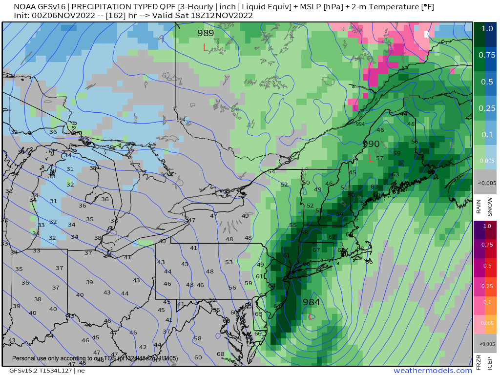
Then we turn our attention to Friday night into Saturday which could feature an accelerating, sopping post-tropical storm that could lash our region with heavy rainfall and some wind, too, before pulling even cooler into the region by end of next weekend.
Stay tuned for updates on these weather changes, have a great day, and remember…
COMMUNITY RESOURCES NEED COMMUNITY SUPPORT
Colorful, educational, practical, WMass-oriented, affordable, gift-able, and peaceful — My 2023 Weather Wall Calendar will hit all those marks for you, but the sale ends on 11/20, so be sure to order or get more info today (link below)
SECURE CALENDAR ORDER/INFO LINK
You can also follow me on Twitter.
AND REMEMBER…
“Hello babies. Welcome to Earth. It’s hot in the summer and cold in the winter. It’s round and wet and crowded. On the outside, babies, you’ve got a hundred years here. There’s only one rule that I know of, babies: Goddamn it, you’ve got to be kind.”
–Kurt Vonnegut
