
Good morning everybody, it’s been gusty overnight in the Berkshires and SVT and quite a mild start for all of us this morning with some fog patches notably in the southern Pioneer Valley and eastern Franklin County.
We’ll be warm this weekend with some sunny periods today but generally clouds will be ruling and increasing through this weekend with gusty southwest winds. One final warm day on Monday and then we cool down to average temps for the 2nd week in November, followed by a brief mildening, and then potential for a rainstorm with cooler temps by next weekend, but before we dive into all of the weather details below, let’s check a note from our new local weekend sponsor, #CranberryHillHealingArts located in Amherst, MA.
——————–
A NOTE FROM OUR WEEKEND SPONSOR:
DHTWN is sponsored by members, patrons, and Cranberry Hill Healing Arts. The turning of the seasons can be challenging, and Carolyn Walker of Cranberry Hill Healing Arts in Amherst is there for you. When you are searching for ways to be at peace, seek relaxation, and feel more energetic, let Reiki & Sound Healing guide you on your journey to wholeness. Through energy work and the gentle vibrations of singing bowls, chimes, and chanting, Carolyn crafts a safe and calming space to experience renewal. Learn more and/or book your session today by visiting their website.
——————————————-
***DHTWN DAILY WEATHER REPORT***
——————————————-
I hope you all have a great weekend to look forward to, and the temps will certainly be easy on the bones and heating bills this weekend, but as with warm stints this time of year, they are fleeting and so be it with our current surge of warmth up the east coast thanks to a strong upper ridge to our southeast.
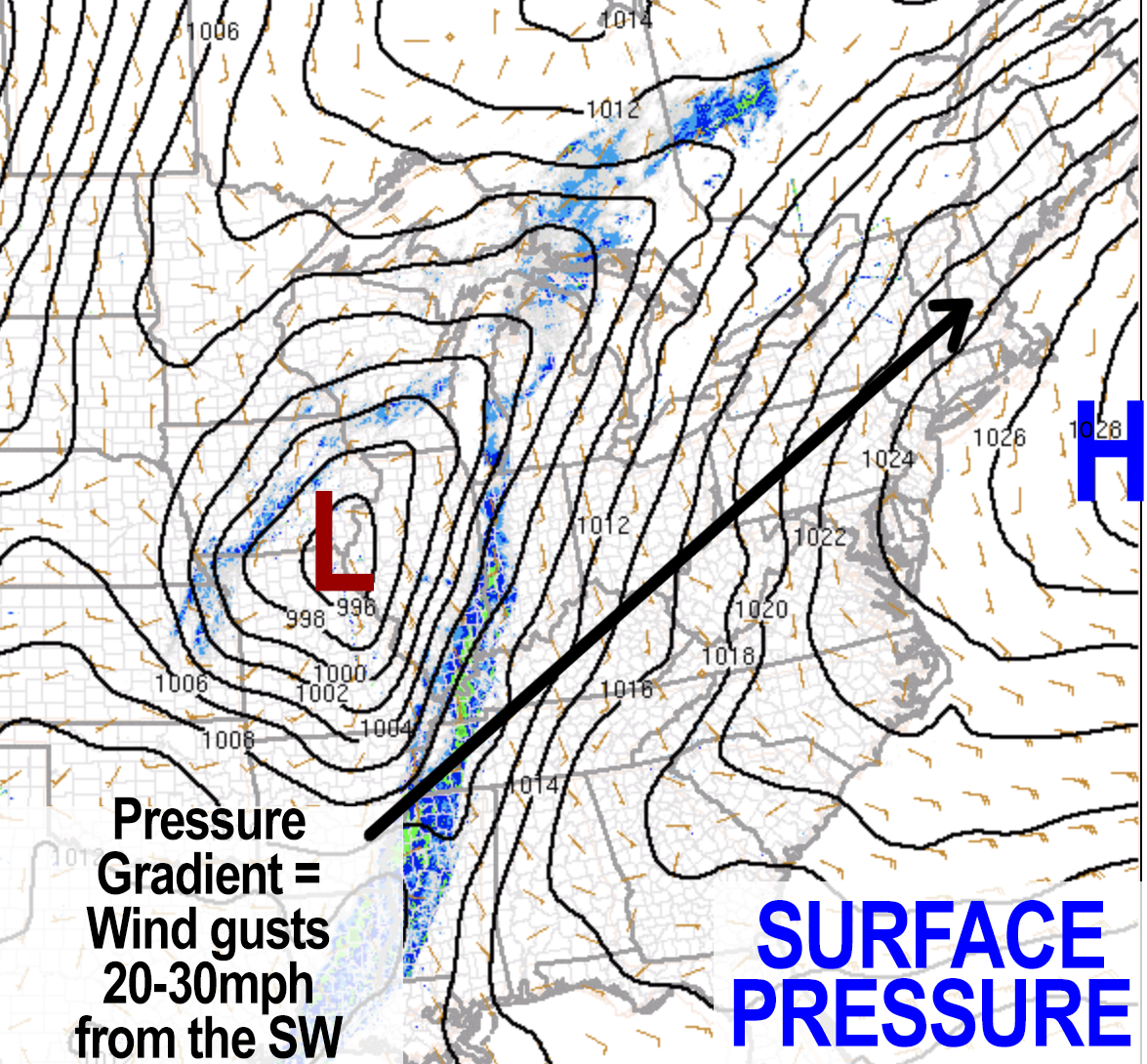
With low pressure over the center of the country and high pressure departing the east coast at the surface, and with warm temps at the surface, we should be able to get southwesterlies gusting 20-30mph today at times, especially in elevated areas already seeing 20mph gusts this morning like the Berkshires and southern VT.
Highs today will climb into the low to mid 70s with partly sunny to mostly cloudy skies. Lows tonight will be quite mild, bottoming out either side of 60º and it will be a bit humid!
For Sunday, breezy winds will continue at times as a shortwave passes northwest of us, which should spawn a few showers especially in SVT, WMass and northwest CT. Highs will again reach into the low to mid 70s under mostly cloudy skies. Lows will be very mild for one final night, near 60º.
A cold front will begin to approach by late Sunday night into early Monday morning as the low now over Iowa tracks northeast and passes to our northwest and pulls colder air from Canada southeast in its wake.
————————
CHRISTINE MORIN SHARES HER LOVE
OF DAVE’S 2023 WEATHER CALENDAR:
“One of the things I’ve enjoyed about Dave’s calendars is the conversations I can engage my grandson in about weather. Sometimes looking out the window isn’t enough. I love the learning moments for both of us!”
———————
A few showers are possible, but this should be a mostly dry frontal passage.
So, after a few morning showers and clouds, sunshine should develop later Monday morning from west to east, and while temps will peak out in the low to mid 70s, they will fall sharply later in the afternoon and evening as colder air advects into our region.
Winds will shift from the southwest to west to northwest in this process, and temps will crash into the 35-40º range by late Monday night.
Tuesday and Wednesday look seasonably cool with highs some 20 degrees colder than Monday, topping out in the low to mid 50s with lows in the upper 20s to low 30s with plenty of sunshine and mostly clear skies at night.
The Canadian high pressure responsible for the mid week cool down will shift east, and on its west side we will see another brief warm up, this time likely into the low to mid 60s or so for Thursday and Friday with continued fair weather.
Then we will have to watch for a coastal storm that may bring a sizable rainstorm to New England, especially southern New England, for Friday night into the weekend with cooler temps expected.
Have a great day, and if you’re the type that values education, check out my very giftable 2023 weather wall calendar.
It’s rich with WMass history, education, beauty and is made for to be a practical daily companion that will keep you connected all year long.
Remember that you can also follow me on Twitter.
AND REMEMBER…
“Hello babies. Welcome to Earth. It’s hot in the summer and cold in the winter. It’s round and wet and crowded. On the outside, babies, you’ve got a hundred years here. There’s only one rule that I know of, babies: Goddamn it, you’ve got to be kind.”
–Kurt Vonnegut