*** 7 Days Remain to order the 2025 Calendar***
Click below to order or get info…
~ An Affordable and Universal Holiday Gift Solution
~ 12 Lovely Local Photos + Cover
~ Lots of Interesting Weather Lessons
~ 12 of my Best Weather-Themed Haiku
~ Much more including tons of celestial info, WMass storms, Holidays etc.
~~~~~~~~~~~~~~~~~~~~~~
TABLE OF CONTENTS
* Daily Celestials (Sun/Moon Data)
* Sponsor Note
* Morning Discussion
* TIP: Scroll below for sections, or read all
~~~~~~~~~~~~~~~~~~~~~~
YOUR DAILY CELESTIALS
~~~~~~~~~~~~~~~~~~~~~~
STAR:
–OUR STAR ROSE AT: 6:27am this morning
–OUR STAR WILL SET AT: 4:39pm this evening
–TOTAL DAYLIGHT TIME: 10 hours and 12 minutes
MOON:
–OUR MOON WILL RISE AT: 9:49am this morning
–MOON RISE DIRECTION: Southeast
–OUR MOON WILL SET AT: 6:17pm this eve
–MOON SET DIRECTION: Southwest
–MOON PHASE: Waxing Crescent (8.3%)
~~~~~~~~~~~~~~~~~~~~~~
A NOTE FROM OUR SPONSOR
~~~~~~~~~~~~~~~~~~~~~~
Dave Hayes The Weather Nut is Sponsored by Individual Community Members, Patrons, and Tandem Bagel Company… No matter the weather, Tandem Bagel is always there for you at several valley locations to make your mornings brighter! With *New Pizza Bagels(!)*, along with bagels baked fresh daily (including Gluten-Free options), house-whipped cream cheese, coffee, and tons of lunch options, Tandem is the perfect quick stop for lunch, breakfast, or a coffee and bagel to go.
You can either 1) visit them in Easthampton, Northampton, Hadley, Florence, and/or West Springfield, 2) hire them to cater your next event, or 3) use their super-streamlined online ordering tool by visiting their website and clicking the “Catering” or “Order Online” links.
~~~~~~~~~~~~~~~~~~~~~~
DHTWN ANNOUNCEMENTS
~~~~~~~~~~~~~~~~~~~~~~
2025 Weather Wall Calendar *Sale Ends SUNDAY*
(Click/Order via Cards, Venmo, PayPal, Check)
~~~~~~~~~~~~~~~~~~~~~~
YOUR MORNING DISCUSSION
~~~~~~~~~~~~~~~~~~~~~~
Good morning folks, we’re starting off quite chilly this morning with temps down into the low to mid 20s for some, and I wouldn’t be surprised if the cold sink in Chester hit the upper teens.
It’s quite frosty out there, and there will be a mix of sun and clouds today with highs only in the low to mid 50s with a light wind.
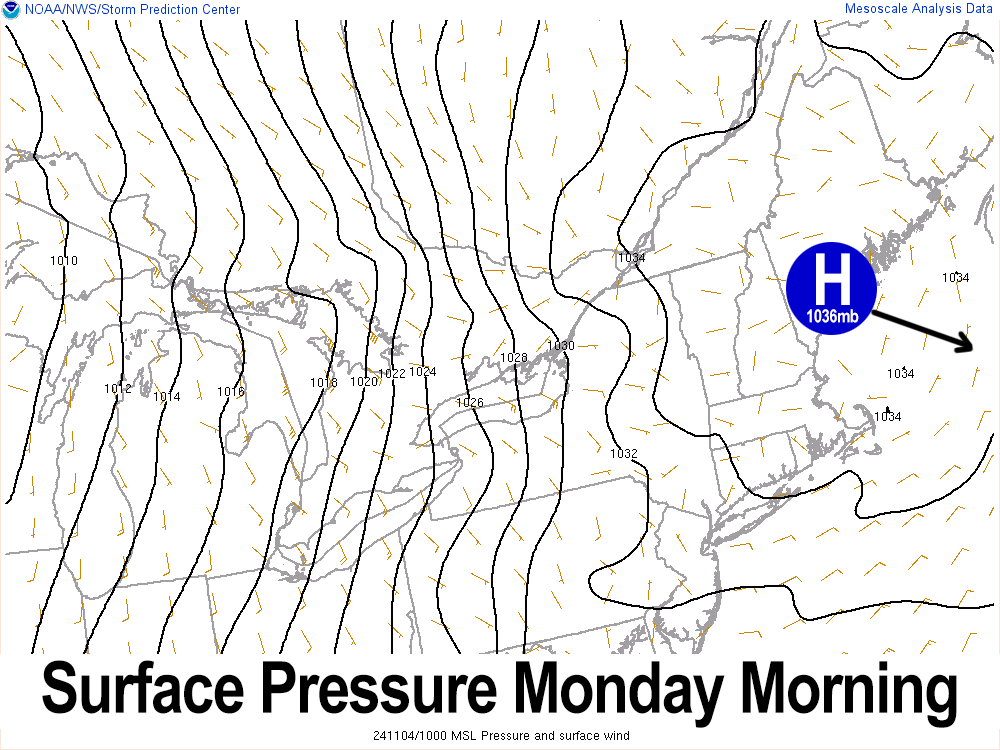
The light wind is thanks to a fleeting high-pressure center currently located over Penobscot Bay in Maine and tracking into the Gulf of Maine with time. As this happens, our flow will turn out of the south, and so lows tonight (along with some cloudiness at times) will hold lows in the low to mid 40s, so a much milder night lies ahead compared to the past couple of chilly morns.
By Tuesday, our temps are heading back up with highs expected to reach the 65-70º range under mostly sunny skies. As a shortwave impacts on the western flank of departing high pressure, the pressure gradient will tighten and southerly to southeasterly winds will pick up Tuesday night, gusting at least 15-25mph, which will raise the potential for fire spread so for those wanting to burn brush piles, stop, wait, and learn some patience, as it’s a good skill to cultivate as a human.
With the southerly wind gusts coming up Tuesday night and clouds around, lows will be quite mild in the mid to upper 50s, with an isolated shower possible.
By Wednesday, our warmth will peak before a cold front comes through on Thursday. Highs will into the low to mid 70s at least and possibly into the upper 70s under partly to mostly sunny skies.
It will be breezy during the day, but the night time is when a low level jet streak will pass closest to us, and could help kick gusts up to 20-35mph out of the southeast and south. Lows will dip to the 40s.
Thursday and Friday look to be mostly sunny behind the front with cooler highs in the upper 50s to mid 60s and lows in the 30s.
By the weekend, temps will sit down even further, with highs in the mid to upper 50s under mostly sunny skies both days and lows in the 30s. Saturday night looks mostly clear, and Sunday starts sunny, but some clouds may increase by end of the day.
This is because we may see a storm exit out of the Rockies and pass into New England. We need the rain very much at this point, for private wells, for fire prevention, and more, so hopefully this storm will come to pass.
Have a great day, and please think about choosing my final 2025 weather calendar as you think about your holiday gift shopping, and keep one for yourself (sale ends in 7 days, this Sunday)
2025 Weather Wall Calendar
(Securely Order via Cards, Venmo, PayPal, Check)
“Follow your bliss and the universe will open doors for you where there were only walls.”
― Joseph Campbell
