
Rain and Wind coming this afternoon and evening, wind lasts through Thursday
–*I POST EVERY DAY* Please visit my page via app or web if you aren’t seeing my work passively showing up on your screens
–Clouds thicken, temps rise into the low to mid 50s
–Showers arrive between late morning to early afternoon
–Rain will fall moderate to heavy at times this afternoon and early evening
–Southerly wind gusts increase, and eventually blow 30-50mph later this afternoon and early evening
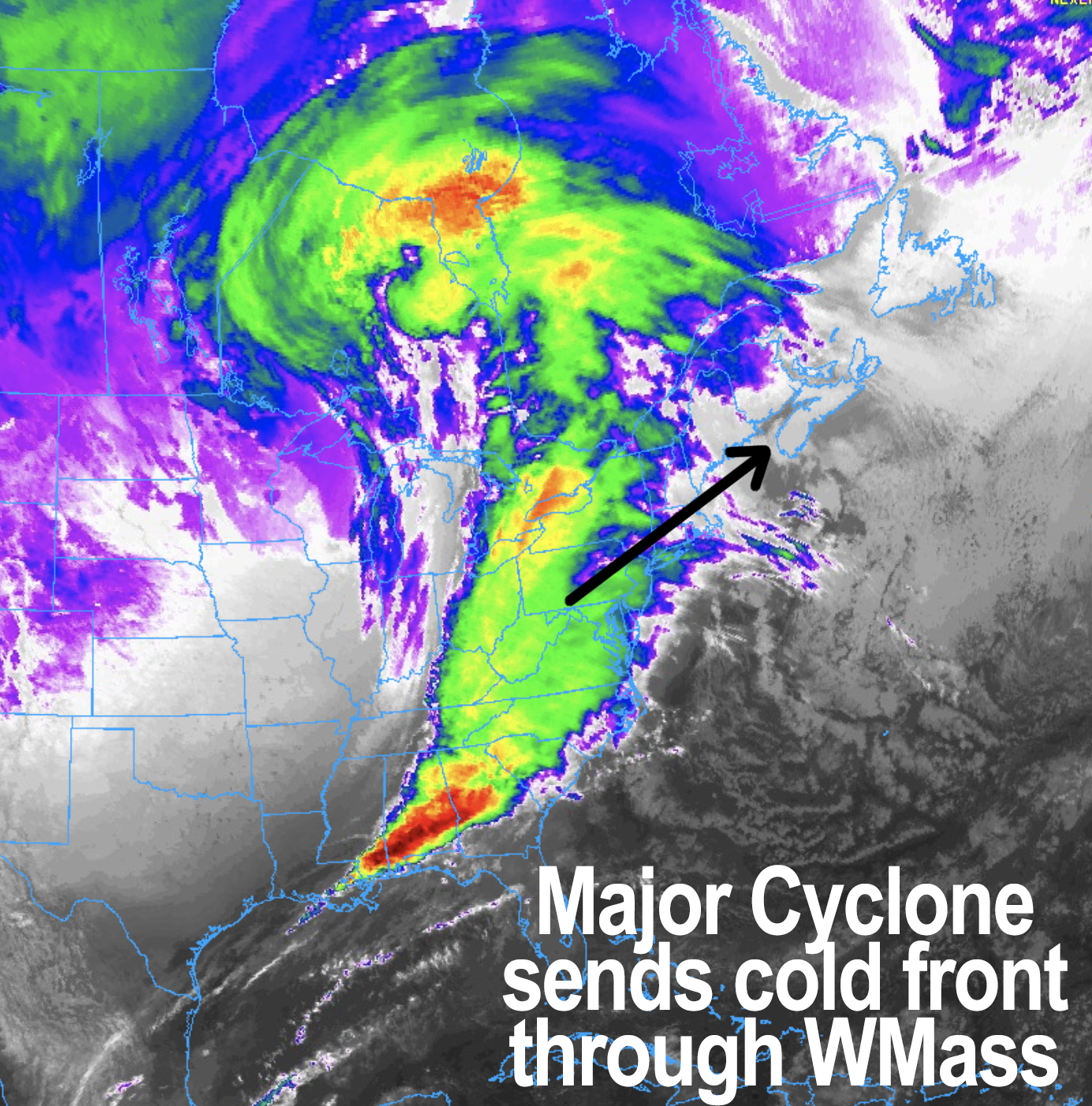
–Cold front swings through between 5-7pm with potential burst of heavy rain, and strong wind shift from south to west, with isolated damaging wind gusts as this occurs
–Westerly wind gusts 25-40mph overnight, then 35-50mph tomorrow as Wind Advisories continue
–Berkshires, Litchfields, Taconics, SVT see some lake effect snow showers after midnight, coatings possible by noon tomorrow, which is blustery and colder
–Nice Friday, more rain and wind on Saturday with a blustery Sunday, similar to today and tomorrow, though likely a little less intense
–Nice Monday, then maybe ANOTHER repeat Tuesday and Wednesday of rain, wind, cooler
–Looking cold by late next week
Before we jump into the weather discussion/details below, let’s check a note from our local and delicious sponsor, #TandemBagelCo, with their newest location in West Springfield, MA.
——————–
A NOTE FROM OUR SPONSOR:
DHTWN Is Sponsored by Members, Patrons & Tandem Bagel Company: No matter the weather, Tandem Bagel is always there for you at several valley locations to make your mornings brighter! With bagels baked fresh daily (including Gluten-Free options), house-whipped cream cheese, coffee, and tons of lunch options, Tandem is the perfect quick stop for lunch, breakfast, or a coffee and bagel to go. Find them in Easthampton, Northampton, Hadley, Florence, and West Springfield, or use their super-streamlined online ordering tool by visiting their website.
——————————————-
***DHTWN DAILY WEATHER REPORT***
——————————————-
NWS ALERTS
–Wind Advisories have been hoisted for the entire greater WMass region!
DHTWN REMINDER
–The odds of being a human is 1 in 400,000 billion… make it count, even in a small way (see Kurt Vonnegut quote at end of post)
DAILY CELESTIAL (STAR):
–OUR STAR ROSE AT: 6:58am this morning
–OUR STAR WILL SET AT: 4:19pm this evening
–TOTAL DAYLIGHT TIME: 9 hours and 21 minutes
NIGHTLY CELESTIAL (MOON):
–OUR MOON WILL SET AT: 11:52pm tonight
–OUR MOON WILL RISE AT: 1:15pm tomorrow afternoon
–MOON SET DIRECTION: West-Southwest
–MOON RISE DIRECTION: East-Southeast
–MOON PHASE: Waxing Crescent (48.8%)
———————-
DAILY TERRESTRIAL (ZoneCast)
ZONE 1 (Northern Region)
Southern VT, Southwest NH, N. Taconics NY
–High Temps: Low to Mid 50s
–Low Temps: Mid 20s
–Wind: Southerly gusts increase by early afternoon, gusting 35-50mph through 6pm, then cold front passes with punch of westerly wind shift with isolated damage possible, then gusty westerlies continue overnight
–Skies: Mostly Cloudy
–Precipitation: Showers arrive by late morning to early afternoon, and quit by early evening
ZONE 2 (Central Region)
WMass, N. CMass, N. Litchfield County, C./S. Taconics NY
–High Temps: Mid 50s
–Low Temps: Mid 20s to Low 30s
–Wind: Southerly gusts increase by early afternoon, gusting 35-50mph through 6pm, then cold front passes with punch of westerly wind shift with isolated damage possible, then gusty westerlies continue overnight
–Skies: Mostly Cloudy
–Precipitation: Showers arrive by late morning to early afternoon, and quit by early evening
ZONE 3 (Southern Region)
S. CMass, S. Litchfield County, NC.CT, & NE.CT
–High Temps: Mid to Upper 50s
–Low Temps: Upper 20s to Low 30s
–Wind: Southerly gusts increase by early afternoon, gusting 35-50mph through 6pm, then cold front passes with punch of westerly wind shift with isolated damage possible, then gusty westerlies continue overnight
–Skies: Mostly Cloudy
–Precipitation: Showers arrive by late morning to early afternoon, and quit by early evening
———————-
MORNING DISCUSSION
Good morning everybody, lots of weather coming into our region over the next week with not 1, not 2, but 3 pairs of warm/cold frontal passages with sizable storms passing well north of us, which will cause southerly-to-westerly wind shifts and gusty conditions today/tomorrow, Saturday/Sunday, and possibly even Tuesday/Wednesday (less certain about that one due to Temporal Proximity, which by the way is the name of new prog rock nerd band, website coming soon, ba dum, crash! ).
For today, a powerful cyclone tracks through the northern Great Lakes and swings its warm front and cold front through New England.
We are starting off cold, but will warm right up as the warm front moves through by late morning into early afternoon, arriving with first rain showers.
We should see temps climb into the low to mid 50s, HOWEVER, should some areas remain in the mid to upper 40s for any localized terrain-based reasons, those areas may see LESS wind, which is why the range of southerly gusts hitting 35-50mph is offered.
Lower temps, less chance for strong wind due to the softening of the temp gradient from surface to sky, known as the “lapse rate”.
Back to business… between 2-8pm I think we get the brunt of today’s system with southerly gusts of 35-50mph, heavier rains, our cold frontal passage (which happens around 6pm), a punch of westerly wind over 50mph possible with isolated damage, and the exit of rain with new air mass moving in by about 8pm.
It will be breezy overnight with lows in the mid 20s to low 30s with gusts over 30mph possible out of the west.
Canada arrives on Thursday with northwest winds gusting 30-45mph, possibly up to 50mph, with highs only in the mid to upper 30s under partly to mostly sunny skies, which means wind chills will be in the low to mid 20s, so bundle up for a wintry day on the first day of Meteorological Winter!
Wind should tamp down at night with lows low to mid 20s, followed by a sweet Friday with sunshine and highs in the low to mid 40s and lows near 30º.
Saturday offers up another rain/wind frontal event that could see Wind Advisories hoisted once again, followed by a blustery Sunday, a nice Monday, and a repeat AGAIN for Tuesday/Wednesday with even colder temps by late next week.
I will get more into details for that Saturday-forward period by tomorrow, but for now, let’s get through today and tonight, I will update again later.
Have a great day, and please check out what I’m calling my Holiday “Cozy’n’Warm” Apparel Sale with 2 new hoodie, sweatshirt, long/short-sleeve shirt designs to keep you and yours warm this cold season, please browse below!
#1: WMASS SNOW LOVERS’ TRIANGLE OF DISAPPOINTMENT
Follow me on Twitter while it’s still a thing.
AND REMEMBER…
“Hello babies. Welcome to Earth. It’s hot in the summer and cold in the winter. It’s round and wet and crowded. On the outside, babies, you’ve got a hundred years here. There’s only one rule that I know of, babies: Goddamn it, you’ve got to be kind.”
–Kurt Vonnegut