[6:55AM FRIDAY 11/29/24] TURNING MOSTLY DRY AND COLDER THIS WEEKEND INTO NEXT WEEK… A FEW SNOW SHOWERS ARE POSSIBLE TONIGHT IN THE BERKSHIRES… NEXT CHANCE FOR A STORM IS LATE WEDNESDAY INTO THURSDAY WITH LIGHT SNOW POSSIBLE AS AN ALBERTA CLIPPER DIVES SOUTHEAST OUT OF CANADA… 2024 APPARREL SALE ENDS MONDAY IN ORDER FOR DELIVERY IN TIME FOR XMAS…

TABLE OF CONTENTS
* Daily Celestials (Sun/Moon Data)
* Sponsor Note
* Dave’s 2024 Apparel Sale Ends Dec. 2nd
* Morning Discussion
* TIP: Scroll below for sections, or read all
~~~~~~~~~~~~~~~~~~~~~~
YOUR DAILY CELESTIALS
~~~~~~~~~~~~~~~~~~~~~~
STAR:
–OUR STAR ROSE AT: 6:57am this morning
–OUR STAR WILL SET AT: 4:19pm this evening
–TOTAL DAYLIGHT TIME: 9 hours and 22 minutes
MOON:
–OUR MOON WILL SET AT: 3:01pm this afternoon
–MOON SET DIRECTION: West-Southwest
–OUR MOON WILL RISE AT: 6:34am tomorrow morning
–MOON RISE DIRECTION: East-Southeast
–MOON PHASE: Waning Crescent (3.1%)
~~~~~~~~~~~~~~~~~~~~~~
A NOTE FROM OUR SPONSOR
~~~~~~~~~~~~~~~~~~~~~~
Dave Hayes The Weather Nut is Sponsored by Individual Community Members, Patrons, and Tandem Bagel Company… No matter the weather, Tandem Bagel is always there for you at several valley locations to make your mornings brighter! With *New Pizza Bagels(!)*, along with bagels baked fresh daily (including Gluten-Free options), house-whipped cream cheese, coffee, and tons of lunch options, Tandem is the perfect quick stop for lunch, breakfast, or a coffee and bagel to go.
You can either 1) visit them in Easthampton, Northampton, Hadley, Florence, and/or West Springfield, 2) hire them to cater your next event, or 3) use their super-streamlined online ordering tool by visiting their website and clicking the “Catering” or “Order Online” links.
~~~~~~~~~~~~~~~~~~~~~~
DAVE’S 2024 APPAREL SALE ENDS DEC. 2ND
~~~~~~~~~~~~~~~~~~~~~~
Folks: Thanksgiving was the perfect Snow Lover’s Triangle of Disappointment example, and now you can express your joy or sadness for living here and claim your place in it.
Design #1. Snow Lover’s Triangle of Disappointment
https://www.bonfire.com/wmass-snow-lovers-triangle-2024
Design #2. Classic DHTWN Logo
https://www.bonfire.com/classic-dhtwn-logo-2024/
HATS (Baseball Cap)
Design #3. Weather Nut Hats
https://www.bonfire.com/dave-hayes-the-weather-nut-hats/
DAVE’S 2025 LAST WEATHER CALENDARS
… Still need a 2025 Weather Calendar?
… I ordered extras, 1stCome-1stServe
https://westernmassweather.com/product/2025-dhtwn-weather-wall-calendar/
~~~~~~~~~~~~~~~~~~~~~~
YOUR MORNING DISCUSSION
~~~~~~~~~~~~~~~~~~~~~~
Good morning everybody, first of all thanks very much for all of your condition and snow reports yesterday, some folks did quite well in the high terrain.
I, for one, have always loved the few times we’ve had snowy Thanksgivings, and I remember one in particular growing up in eastern MA that felt extra cozy as the snow felt outside, so I was certainly grateful to have that experience. We also had one a decade ago on 2014, which put down 6” in the valley floor!!
Cold, inclement weather in any precipitable form is always a nice excuse to prepare food and light a fire if you have a stove or fireplace, and yesterday was no different… I just hope everybody got to/from their events in good shape.
Our storm is now long gone out into Atlantic Canada and the Maritimes, with another low up near James Bay, Canada and high pressure over the center part of the country.
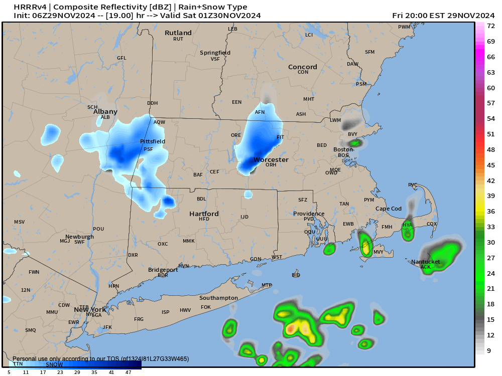
These three elements will set up and feed a west and northwest colder flow of air into our region, leading to gusts today and tonight up to 20mph, along with a few Berkshire and SVT snow showers late today and tonight with some fresh coatings possible.
The rest of us our dry through the weekend and into the first half of next week.
Highs today will only reach the mid 30s to mid 40s with more clouds than sunshine, with lows tonight dropping into the upper teens to mid 20s.
This weekend will see even colder air work into the region with highs in the 35-40º range in the Pioneer Valley points south and east, with highs only in the upper 20s to mid 30s in the Berkshires, western hills and SVT into SWNH. Lows will be in the teens both nights!!
In other words, bundle up, folks, winter is arriving but at least we’ll see plenty of sunshine.
For early to next week through Wednesday I expect similar highs, lows and sky cover, with lighter winds.
By the time Wednesday afternoon rolls around, we may see clouds increasing as a Clipper low center dives southeast out of Canada and heads toward New England.
This may overspread light snow Wednesday night into Thursday with a potential for light snow accumulations, but it’s a long way off and things can change between now and then.
Have a great day, folks, and before the sale end on Monday be sure to pick up a cozy hoodie or sweatshirt to express your joy (or misery) for living in the Western Mass Snow Lover’s Triangle of Disappointment by clicking below:
HOODIES, LONG SLEEVES, TEES, MORE (sale ends Monday)
WMass Snow Lover’s Triangle of Disappointment
https://www.bonfire.com/wmass-snow-lovers-triangle-2024
“Follow your bliss and the universe will open doors for you where there were only walls.”
― Joseph Campbell
