
DAVE’S WEEKLY WEATHER NUTSHELL
–Cold front moves through this morning
–Hight temps for today have mostly been reached
–Clearing happens with time, but clouds early
–NW winds gust 20-30mph, and slacken tonight, cold
–Cool, sunny, calm on Tuesday, clouds increasing at night
–Much milder, more humid, highs 50s Wednesday
–Showers arrive in the afternoon with southerly wind gusts up to 50mph possible, Advisories may be needed
–Wind shifts to NW with colder blustery Thursday expected
–Nice on Friday, cool, but more wind and rain Saturday with Sunday being the weekend pick
Before we jump into the weather discussion/details below, let’s check a note from our local and delicious sponsor, #TandemBagelCo, with their newest location in West Springfield, MA.
——————–
A NOTE FROM OUR SPONSOR:
DHTWN Is Sponsored by Members, Patrons & Tandem Bagel Company: No matter the weather, Tandem Bagel is always there for you at several valley locations to make your mornings brighter! With bagels baked fresh daily (including Gluten-Free options), house-whipped cream cheese, coffee, and tons of lunch options, Tandem is the perfect quick stop for lunch, breakfast, or a coffee and bagel to go. Find them in Easthampton, Northampton, Hadley, Florence, and West Springfield, or use their super-streamlined online ordering tool by visiting their website.
——————————————-
***DHTWN DAILY WEATHER REPORT***
——————————————-
NWS ALERTS
–None
DHTWN REMINDER
–The odds of being a human is 1 in 400,000 billion… make it count, even in a small way (see Kurt Vonnegut quote at end of post)
DAILY CELESTIAL (STAR):
–OUR STAR ROSE AT: 6:55am this morning
–OUR STAR WILL SET AT: 4:20pm this evening
–TOTAL DAYLIGHT TIME: 9 hours and 25 minutes
NIGHTLY CELESTIAL (MOON):
–OUR MOON WILL SET AT: 9:22pm tonight
–OUR MOON WILL RISE AT: 12:23pm tomorrow afternoon
–MOON SET DIRECTION: Southwest
–MOON RISE DIRECTION: Southeast
–MOON PHASE: Waxing Crescent (26.8%)
———————-
DAILY TERRESTRIAL (ZoneCast)
ZONE 1 (Northern Region)
Southern VT, Southwest NH, N. Taconics NY
–High Temps: Mid to Upper 40s, temps fall by afternoon
–Low Temps: Low to Mid 20s
–Wind: Shifts out of the northwest, gusts 20-30mph
–Skies: Partly sunny on average, cloudier early
–Precipitation: None
ZONE 2 (Central Region)
WMass, N. CMass, N. Litchfield County, C./S. Taconics NY
–High Temps: Mid 40s to Low 50s, temps fall by afternoon
–Low Temps: Low to Mid 20s
–Wind: Shifts out of the northwest, gusts 20-30mph
–Skies: Partly sunny on average with early clouds, sunnier eastern sections
–Precipitation: None
ZONE 3 (Southern Region)
S. CMass, S. Litchfield County, NC.CT, & NE.CT
–High Temps: Upper 40s to Low 50s, temps fall by afternoon
–Low Temps: Mid to Upper 20s
–Wind: Shifts out of the northwest, gusts 20-30mph
–Skies: Cloudier early, mostly sunny skies developing
–Precipitation: None
———————-
MORNING DISCUSSION
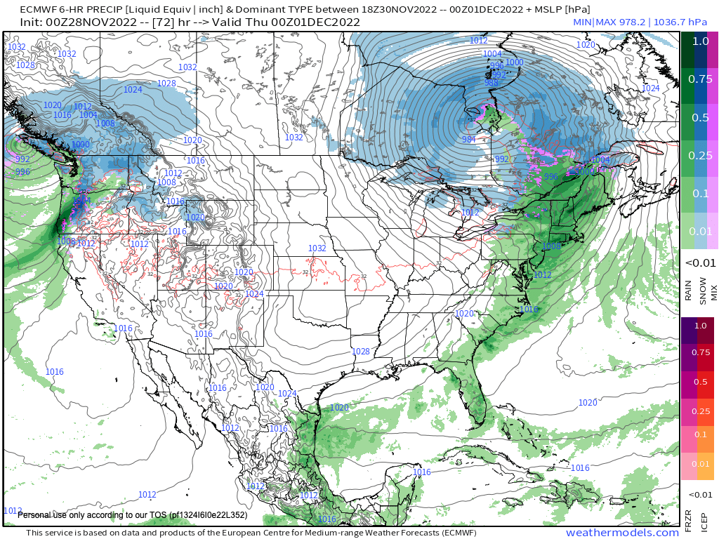
Good morning everybody, our seesaw weather pattern continues as we keep seeing storm systems set up in a general west to east or southwest to northeast track that sends them to our northwest and north.
This means that we usually get a pair of frontal passages (warm first, cold second) or some sort of southerly wind flow followed by a veering wind shift to the west or northwest behind the departing system.
This also produces a surge of milder air ahead of each system, and consequently colder air behind each one (especially this time of year).
That explanation sets up anticipated wind conditions for this afternoon, Wednesday night, and Saturday, and that mid-week system could really pack a windy punch with some folks seeing gusts up to 50mph out of the south, then up to 30-40mph out of the northwest on Thursday.
But I digress!
For today, a cold front is moving through this morning and we’ll see northwest winds develop and gust 20-30mph with highs in the 40s to low 50s: highs that are being realized early this morning.
Temps will fall during the afternoon, and more sunshine should develop as well, given that strong high pressure will nudge in from the west tonight and Tuesday.
After lows tonight in the low to mid 20s with clearing skies, Tuesday looks lovely (albeit chilly) with highs in the upper 30s to mid 40s, and lows either side of 30º as clouds build late.
For Wednesday, a powerful 980mb low will tracking east through southern Canada, with a sharp cold front extending south into the Appalachians.
This will draw moister and milder air north into New England, with highs well into the 50s, and more importantly, strong southerlies are going to gust 30-50mph ahead of this front.
This could cause some isolated power outages by Wednesday night.
As clouds thicken, showers arrive by Wednesday afternoon (with a few in the morning possible), and become heavier late in the day and overnight as the cold front presses into the region. Lows will plunge behind the cold front into the upper 20s to low 30s as rain quits.
Wind will shift around to the northwest and likely gust to 30mph or so with highs in the mid to upper 30s with wind chills in the 20s! Lows drop to the low to mid 20s with clear skies.
Friday looks lovely like Tuesday, though a bit chillier with highs upper 30s to low 40s.
Saturday now looks to produce another cold front with rain and wind, but the impact is more uncertain with this system, so just know that Sunday looks much better for outdoor plans than Saturday, and I will refine the weekend outlook as we get closer.
Have a great day, and if calendars don’t float your boat maybe my 2 new hoodie, sweatshirt, long/short-sleeve shirt designs will keep you and yours warm this cold season, browse below!
#1: WMASS SNOW LOVERS’ TRIANGLE OF DISAPPOINTMENT
Have a great day folks!
Follow me on Twitter while it’s still a thing.
AND REMEMBER…
“Hello babies. Welcome to Earth. It’s hot in the summer and cold in the winter. It’s round and wet and crowded. On the outside, babies, you’ve got a hundred years here. There’s only one rule that I know of, babies: Goddamn it, you’ve got to be kind.”
–Kurt Vonnegut