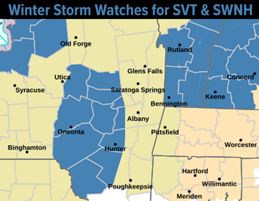
[7:15AM WED 11/27/24] BLACK ICE THIS A.M… THANKSGIVING DAY ACCUMULATING SNOW LIKELIHOOD INCREASING FOR THE HIGHEST TERRAIN OF WESTERN MASS, AND ESPECIALLY FOR SOUTHERN VT AND SOUTHWEST NH WHERE WINTER STORM WATCHES HAVE BEEN HOISTED A POTENTIAL OF OVER 7” OF WET SNOW ON THURSDAY… HILLTOWN FOLKS ABOVE 1500 FEET LIKELY SEE TRAVEL PROBLEMS TOMORROW, STARTING IN THE MORNING… SEEING SIGNALS THIS EVENT MAY BE A BIT STRONGER, A TOUCH COLDER, AND A BIT MORE WINTRY THAN PREVIOUS THOUGHTS, BUT STILL LIKEY SEE MORE RAIN THAN ANY PRECIP TYPE IN THE VALLEY SOUTH AND EAST… THEN COLD AND DRY FRIDAY INTO NEXT WEEK… MY APPAREL SALE ENDS MONDAY NIGHT…

TABLE OF CONTENTS
* Daily Celestials (Sun/Moon Data)
* Sponsor Note
* Dave’s 2024 Apparel Sale Ends Dec. 2nd
* Morning Discussion
* TIP: Scroll below for sections, or read all
~~~~~~~~~~~~~~~~~~~~~~
YOUR DAILY CELESTIALS
~~~~~~~~~~~~~~~~~~~~~~
STAR:
–OUR STAR ROSE AT: 6:55am this morning
–OUR STAR WILL SET AT: 4:20pm this evening
–TOTAL DAYLIGHT TIME: 9 hours and 25 minutes
MOON:
–OUR MOON WILL SET AT: 2:14pm this afternoon
–MOON SET DIRECTION: West-Southwest
–OUR MOON WILL RISE AT: 4:22am tomorrow morning
–MOON RISE DIRECTION: East-Southeast
–MOON PHASE: Waning Crescent (12.8%)
~~~~~~~~~~~~~~~~~~~~~~
A NOTE FROM OUR SPONSOR
~~~~~~~~~~~~~~~~~~~~~~
Dave Hayes The Weather Nut is Sponsored by Individual Community Members, Patrons, and Tandem Bagel Company… No matter the weather, Tandem Bagel is always there for you at several valley locations to make your mornings brighter! With *New Pizza Bagels(!)*, along with bagels baked fresh daily (including Gluten-Free options), house-whipped cream cheese, coffee, and tons of lunch options, Tandem is the perfect quick stop for lunch, breakfast, or a coffee and bagel to go.
You can either 1) visit them in Easthampton, Northampton, Hadley, Florence, and/or West Springfield, 2) hire them to cater your next event, or 3) use their super-streamlined online ordering tool by visiting their website and clicking the “Catering” or “Order Online” links.
~~~~~~~~~~~~~~~~~~~~~~
DAVE’S 2024 APPAREL SALE ENDS DEC. 2ND
~~~~~~~~~~~~~~~~~~~~~~
Need Holiday Gifts, or wanna stay toasty this Winter?
HOODIES, LONG SLEEVES, TEES, MORE
#1. Snow Lover’s Triangle of Disappointment
HATS (Baseball Cap)
#3. Weather Nut Hats
DAVE’S 2025 CALENDARS
Still need a 2025 Weather Calendar?
~~~~~~~~~~~~~~~~~~~~~~
YOUR MORNING DISCUSSION
~~~~~~~~~~~~~~~~~~~~~~
Good morning everybody, it’s very frosty out there this morning with some slick spots due to black ice as the wind never really materialized so dry our surfaces, so take it easy as you step out the door.
After the frost/ice abates, today will be a fine and dry travel day (as will Friday). though an uptick in westerly wind gusts to 20mph is possible this morning before high pressure passes south of us and weakens the pressure gradient.
Highs today will reach firmly into the 40s under partly sunny skies, with lows tonight in the upper 20s to low 30s as clouds increase with our storm tracking east-northeast toward the NYC Metro region.
There are signals that this storm will be a bit stronger/deeper, and if that comes to pass, that means some heavier bands of precipitation, which means a better opportunity for periods of dynamic cooling when it’s precipitating harder.
This tends to equate to valley mixes with snow within a mostly cold rain environment, and heavier accumulating snow in the high terrain above 1000 and especially 1500 feet.
As far as timing as it relates to hilltown / mountain travel tomorrow, you would have to travel either side of dawn to avoid the brunt of this storm system to get where you are going without much headache, or travel tonight and shack up with your people so you are in place when the storm hits tomorrow.
*If* these more amplified trends continue, high terrain parts of western Hampshire, western Franklin, northeast Berkshire Counties, up into southern VT could see 4-10” of wet snow, with a few outages possible in the southern Green Mountains. I wouldn’t be surprised if Mt. Snow or Stratton saw a foot.
Again, rain and snow is moving in between 5am and 9am tomorrow morning from west to east, it should start as snow in much of the Berkshires, western hilltowns and southern VT, or rain/snow mix.
Rain and snow will continue all day tomorrow and abates between 5-8pm, I believe.
Highs tomorrow will only reach the mid 30s to mid 40s with lows in the upper 20s, so more black ice problems are expected late Thursday night.
At elevation, I think much of the Berkshires, northern Litchfield County, western Hampden and western Hampshire Counties, the eastern Franklin County highlands, northern central MA, southwest NH and far southeast VT near the river sees a slushy coating up to 4” of snow possible, depending on your altitude.
Western Franklin County, northeastern Berkshire County and the southern Greens of SVT may end up with 4-10”, IF these deeper low signals come to pass.
Otherwise, it’s a coating to 4” in generally for elevated areas above 1000-1500 feet with a few 6”+ amounts in SVT.
The rest of the Pioneer Valley south into northern CT and east through northeast CT, the rest of WMass, and CMass should see mostly cold rain with some rain/snow mix, and a few slushy coatings to an inch here and there in those elevated areas.
A classic elevation-dependent snowstorm on the busiest travel day of the year… I wish I had better news!!
It’s gets cold and dry and sunny and breezy Friday onward, but for now I am sticking with tomorrow’s storm, and I will update at least once more by this evening, and maybe more as necessary.
Have a great day, and pick up a cozy hoodie or sweatshirt to express your joy (or misery) for living in the Western Mass Snow Lover’s Triangle of Disappointment by clicking below:
HOODIES, LONG SLEEVES, TEES, MORE (sale ends Monday)
WMass Snow Lover’s Triangle of Disappointment
“Follow your bliss and the universe will open doors for you where there were only walls.”
― Joseph Campbell
